Toruń 2017-11-08
Toruń airport.
The army in Toruń.
In 1871, the city was recognized as a 1st degree fortress. The expansion of the fortifications began according to the plans of the then military tactics. A ring of forts was built around Toruń, located approximately 4-5 km from the city. The artillery at that time had a range of up to 4,000 m, so the city could not be fired from the fort. Therefore, the capture of one fort by the enemy did not guarantee the capture of the city. Each fort had 4 artillery batteries and 4 infantry companies. Each fort was built of brick, surrounded by earth in the foreground and surrounded by a moat. The ceilings were covered with at least one meter of soil. Cannons could be hidden. The fort could defend itself for at least one month. There were all facilities inside; ammunition and weapons storage, warehouses, drinking water supplies, kitchen, barracks part, telephone and radio communication. When the terrain required it, small supporting forts were built. The forts were connected by a road known as the "Fortress Road". The city of Toruń is surrounded by a circle of 15 forts, including Podgórze on the left bank of the Vistula. In 1875, most of the work on the forts was completed. Despite the ring of forts, the Germans expected the main attack from the eastern side, from the Russian troops.
Unfortunately, the city lost on the fortification. Further construction restrictions were imposed. Historical buildings erected several centuries earlier were demolished; medieval and renaissance. The Chełmno Tower and city walls were demolished.
Aviation facilities.
At the beginning of the 20th century, Toruń entered the era of aeronautics. In the western part of the city, an airship and balloon port and an airport were built.
The Germans first became interested in airships. At the beginning of the 20th century, balloon and airship technology reached such a level that it could be used in military operations. In the period 1907-1909, over a dozen airship halls were built in Germany. Most of them were in the west, but also in the east. They were established in Poznań, Piła, Słupsk and Toruń.
The airship hall in Toruń was built in 1909. It was medium-sized and intended for Perseval-class airships. It was located in Chełmiński Przedmieście, at today's Generała Józefa Bema Street, in the place where Arena Toruń Hala stands today. Distance about 1,500 m from the city center, north-west. The history of this place is reminded by Balonowa Street.
But already in 1917, the German army transferred all the airships to the Navy. A balloon detachment has arrived in the airship hall.
In Podgórze, at the fort No. 11 (the exit road to Inowrocław and the railway station), a smaller hall for observation balloons was built. Currently, DK No. 15 and S 10.
Both halls were steel structures. Most of the walls are covered with asbestos. All outbuildings are made of brick. On the shorter walls there are large sliding gates. They moved on rollers on rails. The drive was manual with the use of winches and a rope system. The halls were heated by two cast iron furnaces located halfway along the halls. Both halls were situated in the south-east-north-west direction.
The airship hall at the base was 101 m x 25 m, and the height was 23 m. The usable area was 2,525 square meters. The balloon hall was 50 m x 20 m at the base and 20 m high.
Toruń airport.
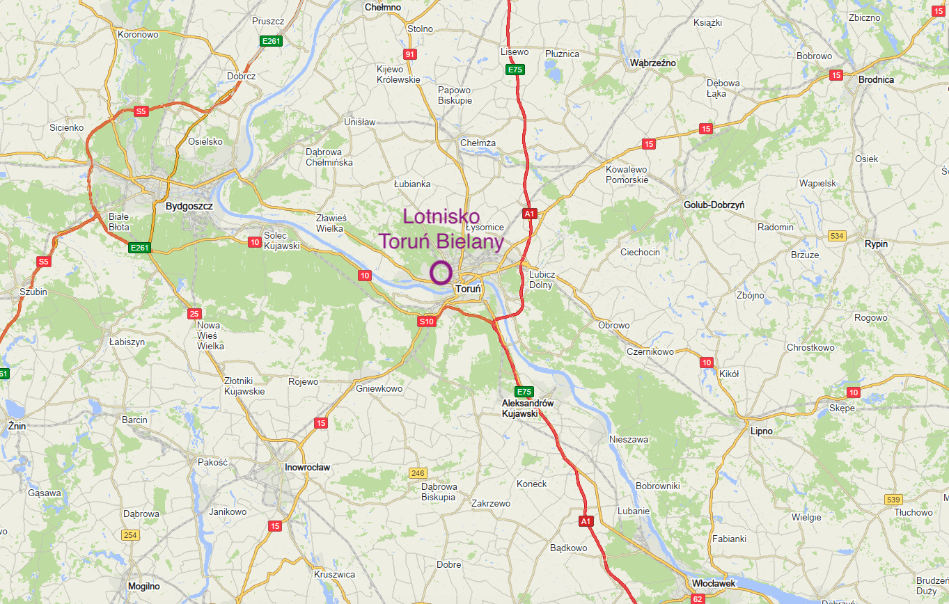
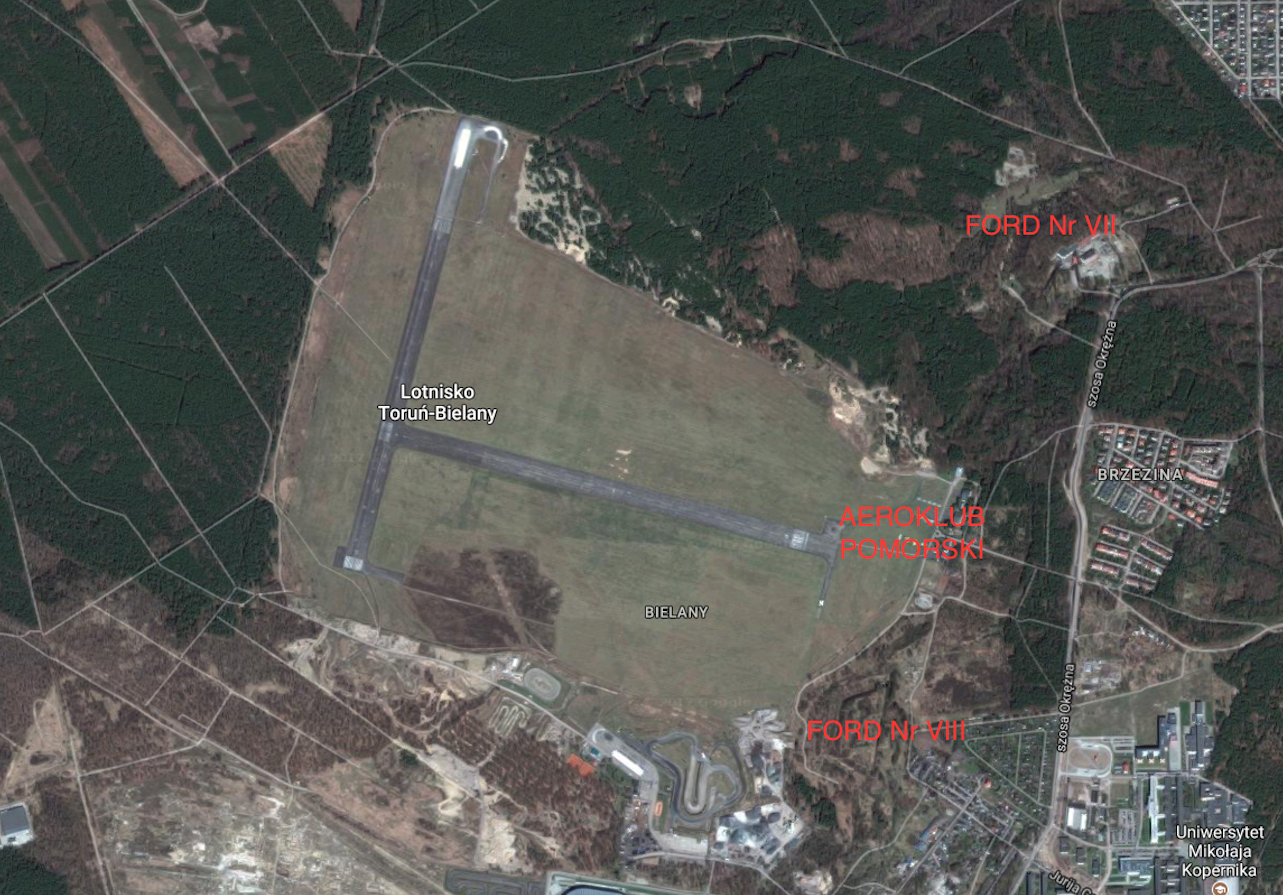
The airport in Toruń was built in the years 1912-1913. They were located in the foreground of fort No. VIII. That is, west of the city, near the Toruń-Fordon-Bydgoszcz road. Direct access was provided by the Fortress Road. Toruń airport served as an aviation school.
The starting area was initially similar in shape to a circle with a diameter of about 300 m. Exactly in the place of the present Tor Toruń Rallycross facility. The field was leveled but not drained. Hangars were erected on the south-west side of the landing area. Probably four. They were of a steel structure. They were covered with eternite and glass. The doors to the hangar were sliding open. Brick buildings were added to the hangars' walls, serving as the backyard of the airport. There were social rooms, warehouses, workshops, etc. Behind the hangars, several wooden barracks were also erected. A railway track ran from the west and north side, from which a siding for the airport was built. As early as 1917, the take-off area was enlarged. Now it was more rectangular with dimensions of 900 m x 750 m.
Written by Karol Placha Hetman