Przasnysz 2019-01-05
Przasnysz Airport - Sierakowo.
Geographic coordinates: 53.009N 20.932E.
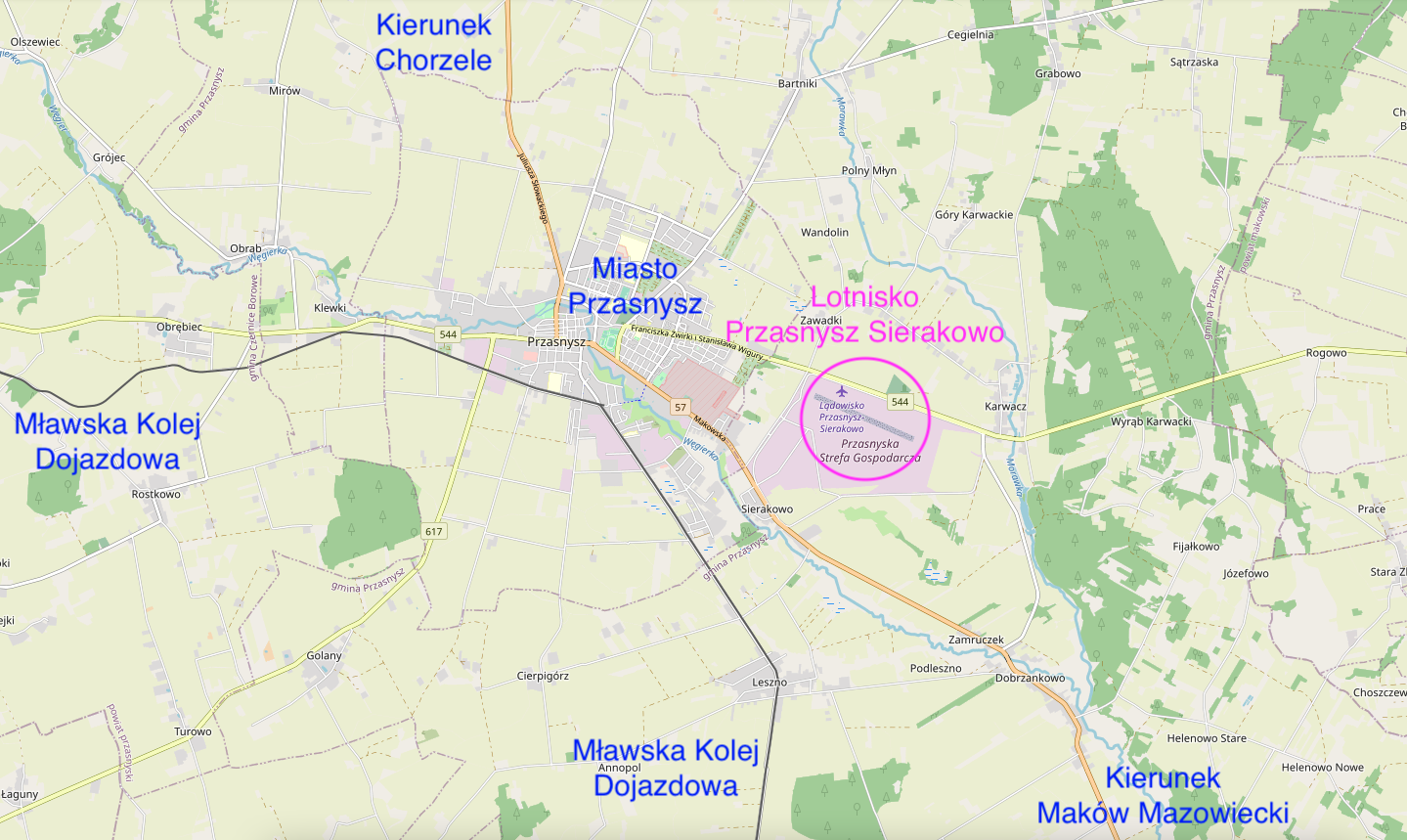
The airport is located approximately 4,000 m from the center of Przasnysz. The airport is located east of Przasnysz, between the national road No. 57 and the provincial road No. 544. The national road No. 57 is approximately 188 km long (north-south direction) and lies in the Warmińsko-Mazurskie and Mazowieckie voivodships. The road connects Pułtusk with Bartoszyce. In addition, it runs next to the Olsztyn Airport in Szymany. Voivodeship road No. 544 (east-west direction) is approximately 164 km long and connects Brodnica with Ostrołęka.
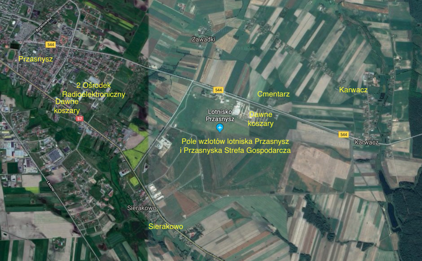
During the German occupation, in 1940, the German army began to partially convert the training field into a field airfield. They located them between the towns of Sieraków and Karwacz. A narrow-gauge railway line from Przasnysz itself was led to the airport. It ended with a loading and unloading ramp. Several wooden barracks were erected for airport service and as warehouses. A bomb depot, a shooting range for aircraft and a fuel and lubricants warehouse were built. No hangar has been erected. The airfield was ready for use in May 1940, and was used to attack the CCCP. The airport was operated by the German army until the end of 1944.
In the period 1945-1951, the airport in Przasnysz was practically unused. The barracks were occupied by the 3rd Cavalry Regiment (1944-1947), and the landing field became a training ground again.
The renaissance of the airport took place in 1951. In 1951, an airport with a tower was built, existing until now (2018). In 1952, a new narrow-gauge railway track was made, from the Mława - Maków Mazowiecki railway line, at Makowska Street. The siding ran first to the area of the military unit, and after passing it, at the height of the shooting range, it turned to the area of the Airport from the Przasnysz - Karwacz road. The siding was used to supply aircraft with fuel, as well as to transport other goods to the unit. At that time, a new MPS with underground fuel tanks was built at the Przasnysz Airport. Then the aviation fuel was transferred to tankers with MZ-51M fuel dispensers, which were mounted on GAZ-51M/Lublin-51 cars. They were called BZs or "gasolines". In the 1950s, aviation fuel type PSM-1 or PSM-2 was used.
In its heyday, the area of the Przasnysz Airport was about 320 hectares. In the 50s, a new bomb depot was built in the Karwacki forest. The area was enclosed by a double barbed-wire fence, where there was a building that housed a small arms warehouse, a guardhouse, a duty station and special warehouses for storing air bombs and ammunition for aircraft. There was a paved road leading to the airfield and the bomb depot, later covered with asphalt. Currently, the area of the former bomb depot is the area of the Przasnysz Forest District.
After the disbanding of the 64th Air Training Regiment, the Przasnysz-Sierakowo airport was used more as a training ground than an airport. Admittedly, operationally, the Przasnysz Airport was subordinated to the 103rd Liaison Aviation Regiment (JW. 1159) from the Vistula Military Units of the Ministry of the Interior and was a backup airport. The home location of the unit was the Warsaw-Bemowo airport.
At the beginning of the 1990s, the Przasnysz airport was transferred to the Military Property Agency. After some time, it was allowed to be sold without maintaining its aviation character. There were several ideas for the development of this area. Eventually, the local authorities treated the area as an industrial zone with the airport kept in use. Therefore, the entire area of the Przasnysz Economic Zone was divided into plots with access to the landing field. The project, worth PLN 34 million, included the construction of internal and access roads, sanitary sewage system, rainwater sewage system, water supply, telecommunications and energy installations. The value of co-financing from the European Regional Development Fund amounted to PLN 28,734,50.00 million. The project was implemented until 2012.
The zone includes: Area of investment plots - 48.67 ha (81 plots, whose area varies from 0.5 ha to 1.03 ha). Area intended for aviation activity: Area of investment plots - 106.89 ha (4 plots, the area of which varies from 3.8 ha to 72.33 ha). The remaining area of the Przasnysz Economic Zone: Area of investment plots - 93.96 ha (86 plots, the area of which varies from 0.47 ha to 22.15 ha). The total area of plots for sale to the Przasnysz Economic Zone - 249.52 ha. In 2018, several entities have already started operating here. Business entities from abroad and even from the USA also showed interest.
On April 20, 2002, the first official meeting of aviation supporters took place, the aim of which was to create a regional flying club using the closed Przasnysz Airport. The initiative was supported by the authorities of the Town and Commune of Przasnysz. The grand opening of the Aeroclub took place on May 3, 2003, and the airport was consecrated by the Primate of Poland, Józef Glemp. Prime Minister Leszek Miller (communist) was also present at the airport.
Already in June 2003, the first glider training was started, groups of 20 candidates. The flying equipment was obtained thanks to the help of the Polish Aeroclub. The first two-seater training glider PZL KR-03 Puchatek was imported. Over time, the Aeroclub was enriched with another flying equipment: the PZL-104 Wilga SP-AHK plane, the two-seat gliders PZL KR-03 Puchatek SP-3548, SZD-50 Puchacz SP-3201, the single-seat gliders SZD-51 Junior SP-3315, 30 Pirate SP-2935. The Aeroclub also had a winch for TUR-2 B gliders. The first aircraft at the Przasnysz Airport appeared in 2003 and it was a STOL CH-701 classified as ultralight.
In 2006, Przasnysz Airport received the ICAO code name - EPPZ. The elevation of the airport is 113 m above sea level (384 ft). The take-off field is dirt with a grass surface. The Aero Club maintains one Runway (RWY) in the direction of 115/295, with dimensions of 800 m x 60 m. (114/294 (11L/29R), 1145 x 60 m, N53°00'39.8" E20°56'01.3" ). It is possible to maintain two more RWYs: 045/225 (04/22), 750 x 60 m, N53°00'25.1" E20°56'05.6", 170/350 (17/35), 850 x 60 m, N53 °00'30.6" E20°55'44.1".
The airport is located in the center of the Przasnysz Economic Zone, where it is possible to purchase service plots with access to the runway. The airport serves training aircraft, General Aviation as well as gliders and motor hang gliders. Glider flights and ULM in the designated area on the south side of the airport. A dirt road runs through the take-off field. The elevation of the airfield in the middle of the landing field.
Radio frequency Przasnysz-Radio 122.6 MHz. Przasnysz - Sierakowo Airport coordinates 53°00′39″N 20°56′02″E. Contact / Contact +48 883 993 001. Possibility of hangaring, snow clearing strip in winter. Access to the hangar is cleared of snow in winter. Hangar space with technical facilities. Rental costs: PLN 500 gross per month (with a longer period of discount). Monitored facility / 24h security. Address Aero Club of Northern Mazovia, Sierakowo 56, 06-300 Przasnysz.
The commercial offer includes: School flights by plane, glider. Glider towing. Washing and hangaring aircraft. Training - raising qualifications, additional qualifications: PPL(A) tourist plane pilot, ULM pilot, glider pilot. Possibility to rent at the airport: lecture hall, accommodation rooms, aviation equipment. Renting a square for outdoor events: harvest festivals, festivals, picnics for companies.
Written by Karol Placha Hetman