Inowrocław 2013-06-23
Inowrocław airport. Jacewo.
Geographic coordinates: 52.827N 18.325E. Elevation 85 m.
History of Inowrocław.
Inowrocław is one of the centers of Staropolskie Kujawy. Sometimes called the City on Salt. Fertile lands were conducive to the development of settlements, mentioned as early as 3,000 BC. In addition, the settlement was located on the Amber Road. On January 20, 1185, the first reference to the princely market "in Novo Wladislaw" comes from the source. The market was located near the Church of the Blessed Virgin Mary. The settlement must have developed dynamically, because already in the 12th century, a brick church was erected here. From 1230, the city became the seat of Casimir I, Duke of Kujawy. The city was surrounded by walls that protected the prince's castle, Franciscan monastery and church, town hall, saltworks and the old part of the settlement. Inowrocław obtained city rights around 1238. In the period 1466 - 1772, Inowrocław was the capital of the Inowrocław Voivodship. The city developed systematically for five centuries. It was in Inowrocław where the talks with the Teutonic Knights took place. Kings of Poland came from Inowrocław; Władysław I Łokietek and Casimir the Great. The decline of the city began with the Swedish Deluge in the 17th century. The Swedes contributed to the outbreak of the plague in the City several times. The long-lasting Northern War (1700 - 1721) brought the greatest devastation. The city, already poor at that time, was ruined by the Swedish army and Muscovites. All attempts to revive the city ended in failure. The city was gradually taken over by the Germanic minority. In 1772, the city found itself under the Prussian plague. From 1836, only Germans could become mayors of the city. Movable goods of Polish culture began to be exported to the west. The duke's castle was demolished, and barracks for the Germanic plague were built in its place. The monks were expelled from the monastery. In such conditions, the patriotism of the humiliated Polish population was born. Secret self-education organizations were established. During the November and January Uprisings, many residents took an active part in them. The relative development of the city took place in the second half of the 19th century. Several new facilities were built: a printing house (1840), the first high school (1848), a new hospital (1870), and in 1873, the construction of a railway line began. At the end of the 19th century, the population increased and reached over 26,000 inhabitants. This was not due to the flourishing of the City, but to an even worse situation in the countryside. In 1875, the first sanatorium was opened. A gasworks, a power plant were built and the first sewage collector was laid. In 1912, the first tram line was launched. The defeat of the Germans in 1918 and the outbreak of the Greater Poland Uprising brought independence to the city on January 6, 1919. In 1922, the city received the official name of Zdrojowisko Inowrocław and became a resort. During the twenty years the city developed systematically. In 1923, the Irena Glassworks was launched. In 1924, another mining shaft of the salt mine was opened. In 1930, the construction of the airport began, which was put into use in 1933. Despite this, many residents remained unemployed. There were riots and protests, which were suppressed by the police.
The city of Inowrocław was developing until the next German war adventure, started together with Muscovites. The German plague organized one of the seats of the so-called Wartheland in Inowrocław. The local Polish population was subjected to unprecedented repressions in the history of the city. Hundreds of inhabitants died in the local prison, in an extremely hard camp in Błonia and in the surrounding forests. Several thousand children were transported deep into Germany and Germanized. The first days of the occupation of the Germanic plague were mass arrests and executions of inhabitants, among which the most famous was the so-called "Bloody Sunday" (night of October 22/23, 1939), carried out as part of barbaric German plans. On the night of November 30, 1939, the German plague drove over 1,000 Polish families from the city. In the period 1940 - 1945, there was a resettlement camp in the city, through which about 10,000 Poles passed, and several hundred of them were murdered. There was a camp for prisoners of war in the Mątwy district. Mostly the British and French stayed there. About 900 of them died here. It is difficult to describe the savagery of the Germanic plague and its bestiality in these few sentences.
On January 21, 1945, the troops of the Moscow State entered Inowrocław, then called the Red Army, and commonly referred to by Poles as the Soviets. And the next chapter of oppressing the Polish nation began.
In the times of the People's Republic of Poland, Inowrocław gained the status of a solar farming center and became a large military aviation base. In the period 1950 - 1999, Inowrocław was administratively within the borders of the Bydgoszcz Voivodship. The administrative change in 1975 did not affect Inowrocław. Since 1999, Inowrocław belongs, as a town and commune, to the Kuyavian-Pomeranian Voivodeship. The very center of the city consists of tenement houses from the 19th century. In the times of the People's Republic of Poland, housing estates with blocks of up to 11 floors were built on the outskirts of the city. Several new industrial plants were also launched.
The city of Inowroclaw.
Inowrocław is located near the Noteć River in the Toruń Valley, on the Inowrocław Plain, in the north-eastern part of the Wielkopolska Lake District.
According to data from December 2012, the city had 72,643 inhabitants and was ranked 49th among the cities of the Republic of Poland. Like all cities in the Republic of Poland, since around 1996, the number of inhabitants has been steadily decreasing. Inowrocław has an area of 30.42 km2. In the commune, 46% of the area is agricultural land. To save the economic situation, since 2013, the city belongs to the Pomeranian Special Economic Zone. The patron saint of Inowrocław is Saint Jadwiga, Queen of Poland. The city is a strong military garrison. In addition to the air force of the land forces, an engineering regiment associated with the railway is stationed here.
National and provincial roads intersect in Inowrocław: No. 15 (Toruń-Inowrocław-Gniezno section), No. 25 (Bydgoszcz-Inowrocław-Konin section), No. 251 Inowrocław-Żnin, No. 252 Inowrocław-Włocławek. Inowrocław is to receive an eastern bypass marked No. S15.
Inowrocław is an important railway junction. It has a connection with Bydgoszcz, Toruń, Gniezno, Poznań, and via the coal main with the south of the Republic of Poland. All passenger trains stop at the railway station in Inowrocław. Railway lines in Inowrocław: Line 353 - Poznań East - Skandawa, Line 131 - Chorzów Batory - Tczew, Line 742 - Inowrocław - Inowrocław Rąbinek, Line 206 - Inowrocław Rąbinek - Drawski Młyn, Line 231 - Inowrocław Rąbinek - Mogilno.
There is public transport in Inowrocław. MPK Inowrocław operates 14 day lines and 1 night line. The fleet is modern and consists of several dozen buses of various brands, including: Solaris, Jelcz, Mercedes, MAN, Iveco, Solbus, Kapena and others. Public transport in Inowrocław was established in 1912.
Airports in Inowrocław.
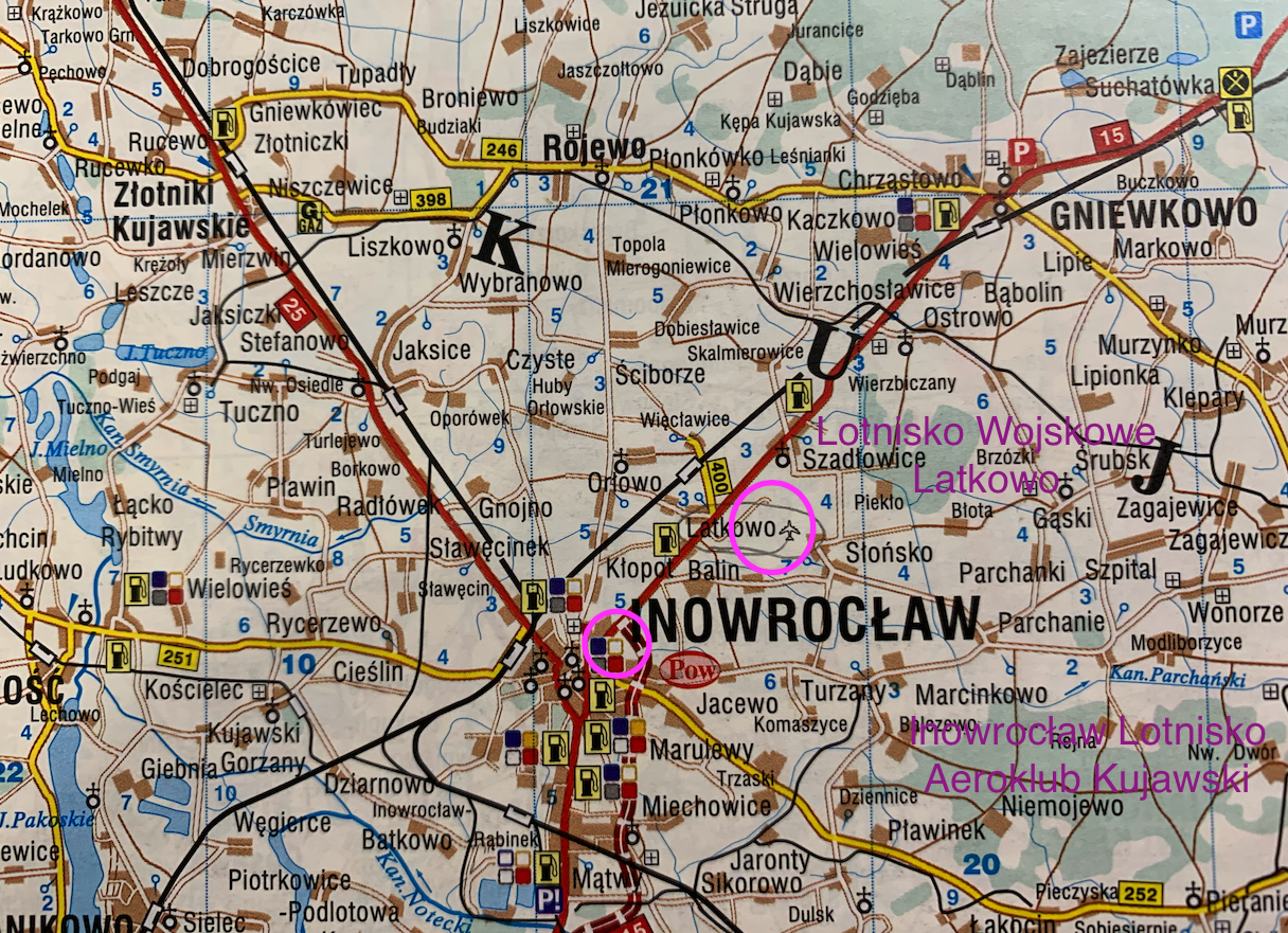
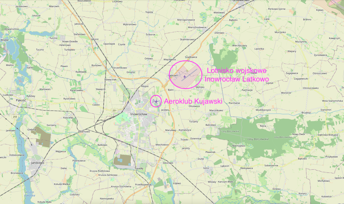
At the outset, we must write that Inowrocław has two independent airports.
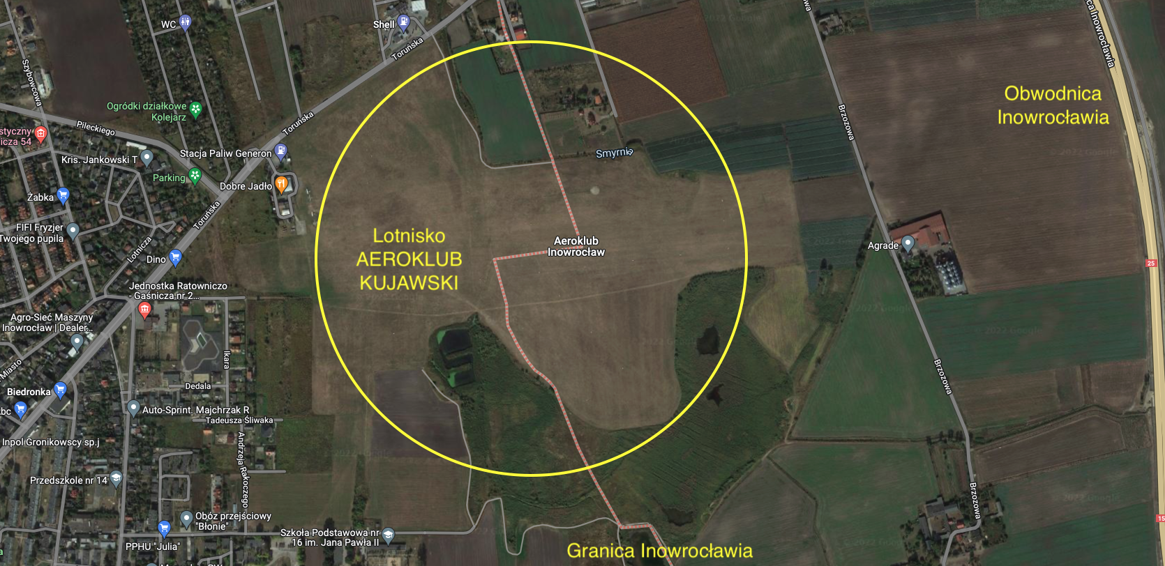
The first airport is located at Szosa Toruńska, within the administrative borders of the City and is owned by Aeroclub Kujawski. EPIN code.
The second airport is also located at Szosa Toruńska, but further, 5 km from the city center and is the Military Airport, 56th Air Base.
In 1980, in Inowrocław, at the hospital (Poznańska Street), a landing pad for ambulance helicopters was opened.
Inowroclaw Jacewo EPIN Airport. 1933.
Inowrocław EPIN Airport is a typically Polish airport, which was established in the interwar period.
The beginnings of the airport in Inowrocław date back to the summer of 1929, when the 6th week of the Air and Gas Defense League was held in the city. The Air and Anti-Gas Defense League was a thriving organization that was established in the free Republic of Poland, and the profile of its activities was dictated by the great world war. The idea of building an airport in the capital of Kujawy met with the approval of the city's main authorities. The vice-president of the city, Mr. Władysław Juengst, was considered the father of the whole undertaking. The airport is located at the so-called Szosa Toruńska. About 50 hectares have been allocated for the facility, so far used as a military training ground of the Inowrocław garrison. The locals used to call this area Błonia. The construction of the airport began in 1930, although other sources give the date of 1933. In June 1933, at the beginning of summer holidays, all schoolchildren came to the airport to tidy up the area. Importantly, each of these young people brought a bag of earth with them. It was a symbol similar to the construction of the Piast mound, only to measure the new twentieth century.
Aeroclub Kujawski in Inowrocław was established in January 1933 as the eighth aeroclub in Poland. He was given the name of "First Marshal of Poland Józef Piłsudski". The official opening of the airport took place on September 24, 1933. The flying club developed dynamically. The number of members and trained airmen increased. Among the graduates was Captain Kazimierz Burzyński, a pilot of LOT Polish Airlines. There was also Mrs. Krystyna Klimaszewska known under her maiden name of Ganowiczówna (1913 - 1999) - the Polish champion in gliding from 1935, a resistance activist in the structures of the Home Army Main Command, under the pseudonym "Ewa".
At the end of the 1930s, the airport was expanded and a civil airport certificate was sought. The airport was to serve the local spa. Unfortunately, all these activities were interrupted by German and Soviet onslaughts, which started the Second World War. After World War II, in 1945, the Aeroclub returned to its activity. Many members have written a beautiful page in the history of Polish aviation, winning numerous medals and laurels. Currently, Aeroklub Kujawski conducts training in six sections: airplane, glider, paragliding, microgliding, parachuting and modeling.
The main facility of the airport was a hangar with facilities. After three years of construction, on September 24, 1933, the official opening of the airport took place. The event began with a holy mass, during which the new facility was consecrated and named after the First Marshal of Poland, Józef Piłsudski. It was a great celebration, attended by almost all residents of the city of Inowrocław and the surrounding area. In the first days, many people who wanted to watch the planes came to the airport. As part of LOPP, an aviation and modeling section was established. At the same time, in 1932, the Kujawy Section of the Poznań Aeroclub was created, which on January 19, 1933 became the Kujawy Aeroclub, existing to this day. The gliding section of lowland aviation became the main section of the flying club. The 5th National Gliding Competition was held for the first time in lowland areas in 1937, in Inowrocław. The pupils from the Inowrocław Airport often joined the Polish Military Aviation. Many of them stood up to defend the Polish Heaven against the Germanic plague in September 1939. In the defense plans of the Republic of Poland, Latkowo Airport was treated as a spare one for units based in the nearby ones; Toruń and Bydgoszcz. After World War II, the Aero Club of Kujawy reactivated its activities. Many pilots of gliders, airplanes and parachute jumpers have been trained here. There were also successes in modeling. Several times a year, gliding, paragliding and airplane competitions are organized at the airport.
Inowroclaw Jacewo Airport.
The airport has the ICAO code - EPIN. Has geographical coordinates; N 52 degrees 48 minutes 23 seconds, E 18 degrees 16 minutes 50 seconds. It lies at an altitude of 85 m above sea level. As standard, it has three parallel runways with a ground surface (grass); direction 14/32 760 m x 100 m, direction 14/32 690 m x 100 m, direction 14/32 390 m x 100 m. The radio operates at a frequency of 122.6 MHz.
The main building of the airport is a hangar with a base of about 25 m x 40 m. In addition, there are several other buildings. The flying club is the owner of several light, single-engine planes and gliders.
The Inowrocław airport is located in the north-eastern part of the city of Inowrocław, practically on its border, at 160 Toruńska Street. The airport's landing field is irregular in shape. In the latitudinal direction, it has a maximum length of 1,000 m, and in the meridional direction, it has a length of 900 m. The area of the ascent field is about 45 hectares. The airport has one RWY direction 14/32, 760 meters long and two additional RWYs, 690 and 390 meters long.
RWY 1: 078/258 (08/26), 760 x 100 m. RWY 2: 314/134 (31/13), 690 x 100 m. RWY 3: 004/184 (36/18), 390 x 100 m At the airport, the following applies: for powered aircraft, the right aerodrome circuit and for non-powered aircraft, the left aerodrome circuit. Due to natural obstacles, it is forbidden to T/O from RWY 31 and LDG to RWY 13. Gas station on the other side of the road.
ICAO airport code: EPIN. Address ul. Toruńska 160, 88-100 Inowrocław Phone: 52 357 32 28 Mobile: 693 353 228.
From July 1, 2022, the current frequency of 122.605 MHz at the Inowrocław EPIN airport (Inowrocław Radio) will be replaced by a new frequency of 120.810 MHz.
Written by Karol Placha Hetman