Gryfino 2023-03-09
Gryfino railway station.
Geographic coordinates: 53.254N 14.492E.
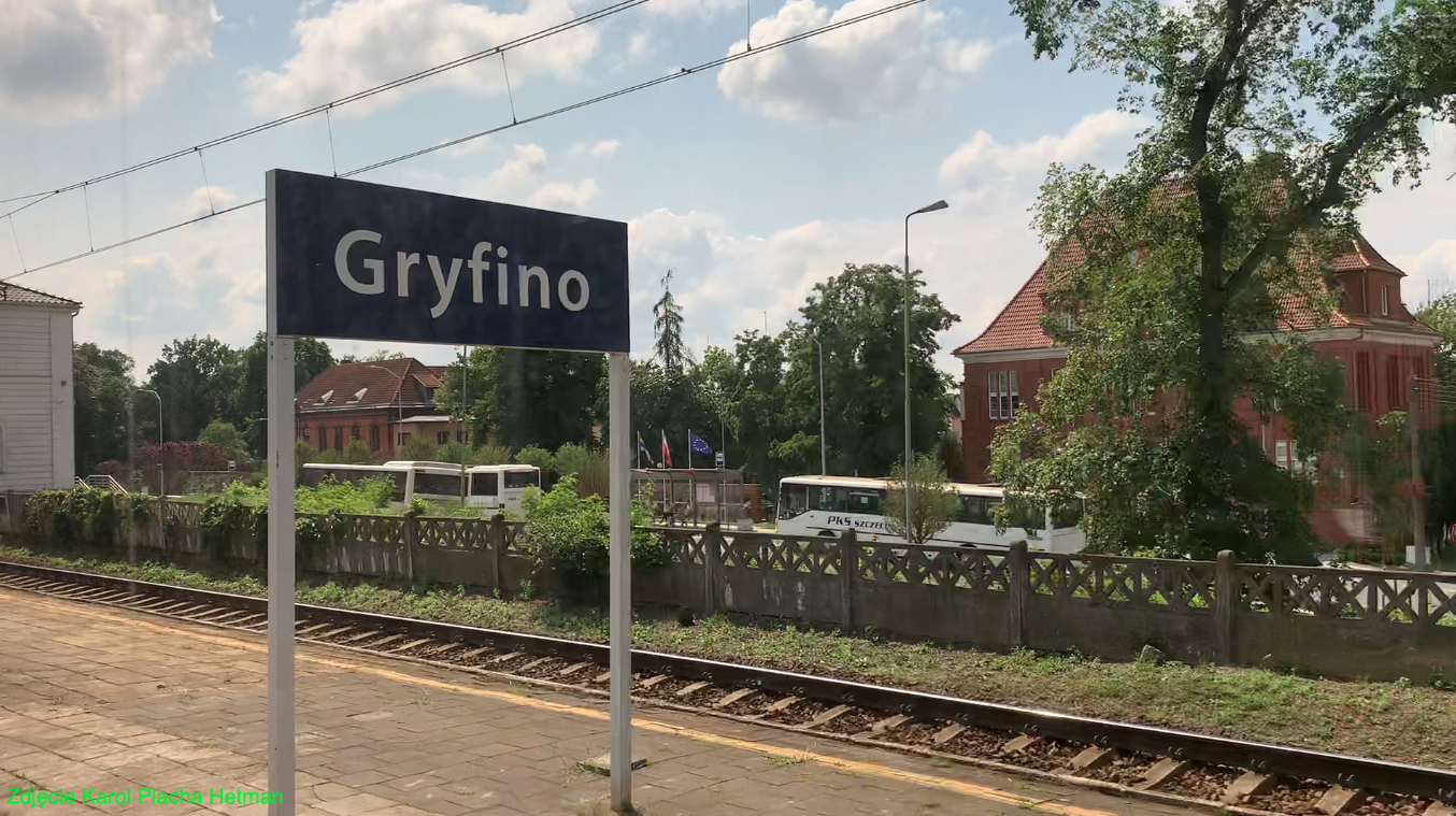
Photo description: View of the station square. From the right; The building of the Starosty, the Polish Post Office and a fragment of the station.
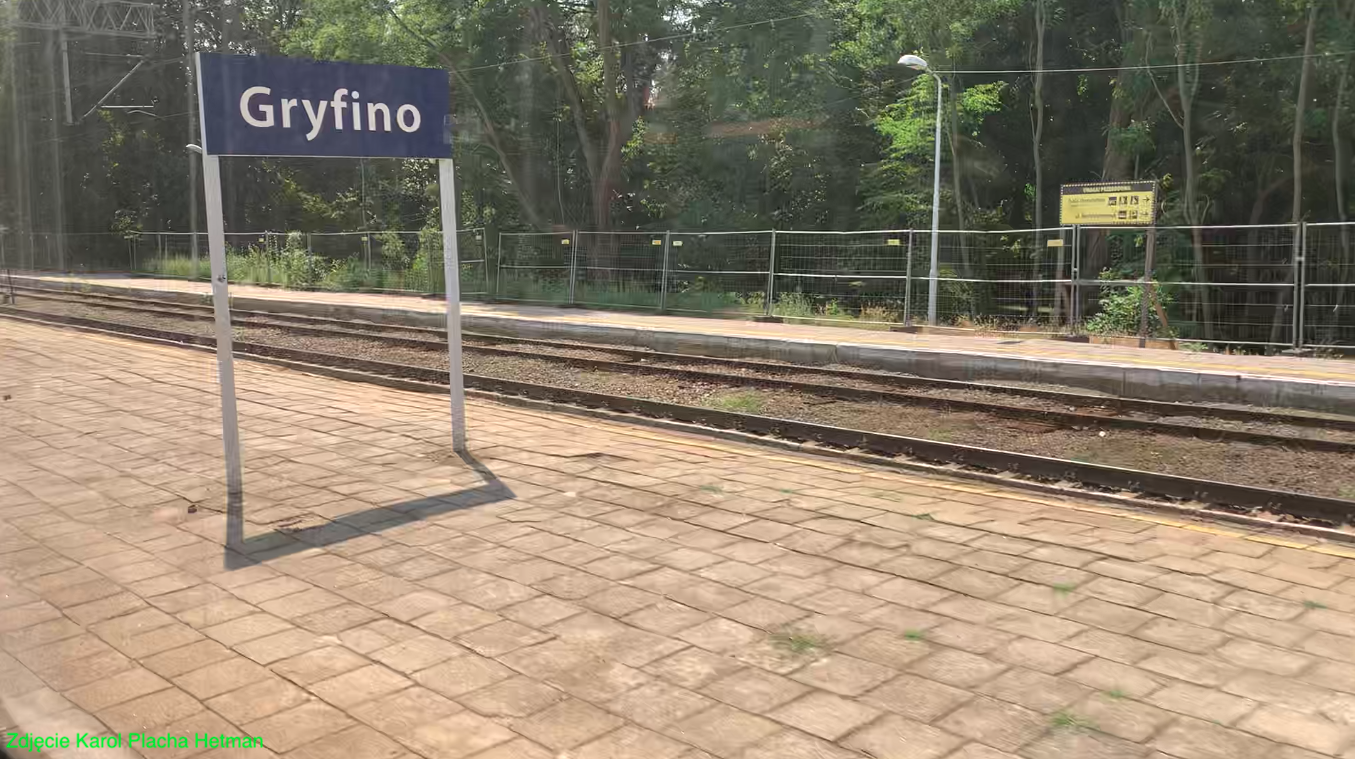
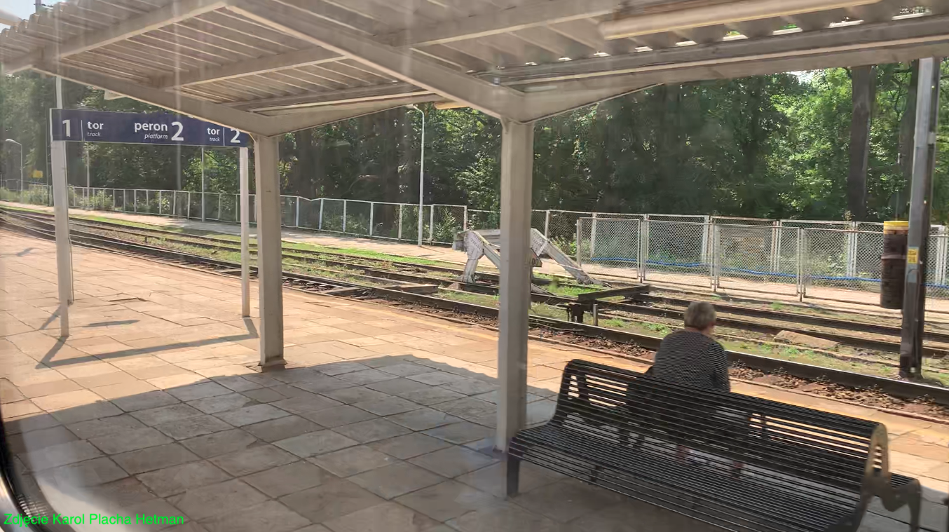
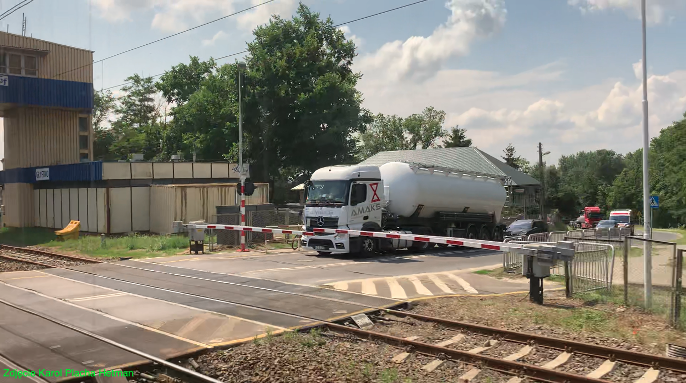
Photo description: Armii Krajowej Street and the "Gf" signal box.
The city of Gryfino.
Gryfino is a city in Poland in the West Pomeranian Voivodeship, situated on the Odra River in close proximity to Szczecin (27 km). The city has an area of 9.54 square kilometers. The population of the city is 20,792 inhabitants (2021). The city is spread out on the right bank of the Oder river, without a clear center, which was destroyed as a result of World War II.
The settlement was founded by the Slavs in the early Middle Ages as a fishing village. A port of things has been built. The city rights were granted in 1254 by Prince Barnim I. Thanks to the Oder River, the city developed quickly, getting rich on trade. Craft guilds were assumed. From the 14th century, Gryfino was a member of the Hanseatic League. The increasingly strong union with Szczecin resulted in the decline of Gryfino's importance. The city was not spared by fires, floods and plagues. In the period 1640 - 1679, the city was under the rule of the Swedes, who, retreating, razed the city to the ground and destroyed all the surrounding bridges and the river port. There was a commercial decline in Gryfino. In the eighteenth century, the inhabitants were still not prosperous. Therefore, agriculture was gaining in importance. Another development of the town was brought about by the railway connection between Gryfino and Szczecin, which was launched in 1877. In 1904, the regulation of the Odra River began, which reduced the flood risk. Weirs were built on the river. The last flood affected the city in 2002. At the beginning of the 20th century, several factories were established in Gryfino; tannery, soap factory, hat factory, slaughterhouse, brewery, sugar factory, brickyard.
The tragedy for Gryfino was the Second World War. Stupid Germans invaded Poland and other countries in Europe, together with their Muscovite brothers. As a result of this war, between March 8, 1945 and March 24, 1945, there were fierce battles for the bridge over the Oder River. The city was turned into a fortress that could not be defended. The city was destroyed in 70%. As a result of the great agreements of this world, Gryfino was incorporated into Poland.
Poles initially called the city - Gryfino. In 1946, the Polish name of the town was approved - Gryfino. The Gryfino form was introduced by the ordinance of the Ministers of Public Administration and Regained Territories of May 7, 1946. The indigenous people were displaced to the rajch, and Polish settlers came here, who had been displaced from the Polish Borderlands, which were incorporated into the CCCP.
In 1970, the construction of the "Dolna Odra Power Plant" began, which was launched in 1974. For its employees, a new housing estate was built in the city - "Górny Taras". The power plant influenced the dynamic development of the city. In 1975, the city had 10,000 inhabitants, and in 1987, there were already 20,000 inhabitants.
"Cukrowania Gryfice" was launched in 1898. After the Second World War, on November 29, 1948, the first Polish sugar campaign was launched. The factory produced sugar until 2006. The sugar factory buildings were demolished in 2012. The closure of the sugar factory resulted in the liquidation of the narrow-gauge railway network.
Currently (2023), apart from the "Elektrownia Dolna Odra", there is a timber industry. There is a sawmill and two charcoal plants. There are also factories: rubber products, plastics and a foundry.
There are few historical monuments in Gryfino. There are fragments of defensive walls, built mainly of field stone. The construction of the defensive walls began in 1284. Two gates in the city walls have been preserved. The monument is the Church of the Nativity of the Blessed Virgin Mary, previously Saint Nicholas. The construction of the temple in this place began in the 13th century. The building of the Polish Post Office is historic. The post office building was built in 1883, right next to the railway station, on the Kostrzyn - Szczecin railway line. The attractions of Gryfino are: "The Lower Oder Valley Landscape Park" and the "Krzywy Las" natural monument.
Road communication.
National road No. 31: Szczecin - Gryfino - Kostrzyn nad Odrą - Słubice. Provincial road No. 120 state border - Gryfino - Kobylanka. The main crossing over the Oder River is the bridge along road No. 120, which is an extension of Piastów Street. The bridge is 246 m long and has three spans. The total width of the bridge is 10.3 m. The bridge in its present form was built between 1911 and 1913. In 1945, the middle span was destroyed. The reconstruction was completed in 1955. The last renovation was done in 2006.
Narrow-gauge griffins.
There were narrow-gauge railways in Gryfice. Former locomotive depot. Currently, there is a permanent Exhibition of Pomeranian Narrow-Gauge Railways in Gryfice. The exhibition was created in 1993 from the former museum and open-air museum of narrow-gauge railways of Western Pomerania, operating since 1973. The exhibition is located at 2 Błonie Street and covers 5,500 square meters.
Gryfino railway station.
Geographic coordinates: 53.254N 14.492E.
The railway station in Gryfino was launched on May 15, 1877. Names of the railway station: Greifenhagen 1877 - 1945. Gryfino nad Regalica 1945 – 1946. Gryfice from 1946 to the present (2023).
In 1877, Gryfino received a railway connection with Szczecin and Wrocław. Later, the station became the starting point for the Gryfino-Pyrzyce line. This line was created in two stages; in 1895 to Chwarstnica, and in 1898 extended to Pyrzyce. EMUs have been running on the Gryfino - Szczecin line since 1983. The electrification of the Szczecin - Zielona Góra route was carried out in the period 1980 - 1983.
The station was built. To the north of the station, a brick water tower was built. A railway warehouse was built between the station and the tower. Due to the slope, the square in front of the station was small. A railway siding was led from the station to the river port. As a result of the Second World War, the water tower was destroyed. After the war, a new water tower was built, which resembles a three-storey building.
There were shape semaphores at the station until electrification. Even in the 1980s, steam locomotives dominated the station. In the 1990s, local trains consisted of SM42 diesel locomotives and "Bonanza" cars. Diesel wagons of the SN61 type also operated. Periodically, retro trains pulled by steam locomotives, such as the Ol49, ran. After electrification of the main route, passenger traffic began to be served by EMU EN57, with the exception of the route to Pyrzyce, which was not electrified.
The station was put into operation on May 15, 1877. It was a two-storey building, typically Prussian, with a flat roof and a basement, the construction of which resulted from the foundation of the station on a slope. You had to climb stairs to enter the building. In 1910, the station was expanded, the roof over the platform was enlarged and an additional restaurant room was added. The building was destroyed in March 1945 and was rebuilt according to a changed design. Currently, it is a three-storey building, built of brick. For many years the building was not plastered. Later it was plastered and painted grey. The last renovation of the station was carried out in 2011, and it was put into service on November 15, 2011. Now the building looks like a palace. At night, the station is illuminated, which emphasizes its shape. There is a waiting room, ticket offices and toilets in the building. The building houses the Poviat Labor Office and law firms. There used to be a railway health clinic in the building.
The last renovation of the square in front of the station was done in 2020. The layout of streets and stops was reconstructed. Buses and buses of various carriers and in different directions depart from the station square. At the station square there is an impressive building of the town hall - the District Office, the City and Commune Office, the district hospital and an equally impressive building - the Polish Post Office. Nearby is the Palace under the Lions and the 1st Secondary School. Most of these buildings were rebuilt after the war.
In the period 2013 - 2019, the tracks at the Gryfino station were renovated. At that time, the turnout leading to the trail towards Pyrzyce was closed. Semaphores were replaced in accordance with the new track layout. A water crane was painted as a souvenir of the steam traction.
Platforms at the station.
The number of platforms is 3. The number of platform edges is 4. Platform 2 is the most important and is an island platform with two edges and is 305 m long. The platform is roofed with a 50 m long canopy. 50 m. Trains to Pyrzyce departed from this platform, and its location is in the eastern part of the station. Platform 3 is a single-edge platform located to the north of the station building. Platform 1 is 200 m long and faces the west. The platform had a shed, which was demolished in 2010.
The tunnel under the platforms and tracks was built around 1930. There is no entrance to the tunnel from the station building. The tunnel is used by travelers and residents, because the tunnel connects both parts of the city.
Passenger traffic.
The Gryfino railway station serves approximately 1,900 passengers per day (2020). Currently, 29 passenger trains leave the Gryfino station daily (March 2023). You can go to: Chojna - 3 PolRegio trains. Kostrzyn - 2 PolRegio trains. Kraków - 1 InterCity "Chełmoński" train. Lublin - 1 TLK "Wyczółkowski" train. Przemyśl - 1 InterCity "Matejko" train. Rzepin - 1 PolRegio train. Szczecin - 13 PolRegio trains and 2 InterCity trains. Świnoujście - 11 PolRegio trains, 2 InterCity trains, 1 TLK train. Zielona Góra - 4 PolRgio trains, 2 InterCity trains.
Railway lines:
Railway line No. 273 Wrocław Główny - Szczecin Główny. It is colloquially called: Oder line, Oder main line, Nadodrzanka. The line has a length of 356.125 km. It is mostly two-way. By 1983, it was fully electrified.
Railway line No. 419 Pyrzyce - Gryfino. Currently (2023) the line does not exist. The line had a length of 30.771 km. She was launched in 1895. Rail traffic was suspended in 1996. In 2009, the line was dismantled. The line was single-track, non-electrified. There were stations and stops on the line: Młynki, Żórawie, Wirówek, Jezioro Wirów, Chwarstnica (branch to Swobnica), Sobieradz (branch to Szczecin Zdroje), Skrzynice, Parsów, Bielice Parsów, Lines, Stare Chrapowo, Nowe Chrapowo, Rzepnowo, Pyrzyce.
Route of the line: Line No. 419 departed from line No. 273 in the area of Słoneczna Street in Gryfino, southwards from the Gryfino station. The tracks ran east along the River Continue. In two road and rail crossings, tracks have been preserved, which are filled with concrete slabs. Further on, the line bypasses Lake Chwarstnickie. In Chwarstnica there is a bicycle path (asphalt) along the former route to Swobnica. There are no traces of the rail-road crossing. Further on, the trail ran between fields and small forests. At the national road No. S3 there are no traces of the track. Further on, the line passed Lake Sobieradz. Only the station plain remained after the station Skrzynice. There is no building. The station was in a strange place because there are no villages nearby. In Bielice, the line passed sawmills that used rail transport. In Jana Pawła II Street, the tracks and concrete slabs of the rail-road crossing have been preserved. There are two sawmills: Tartak Bielice and Tartak "Alvita" Bielice. The trail continued through the fields. Then there is the town of Linie, which is wealthy with a palace and a church under the challenge of St. Joseph. Next is Stare Chrapowo and Nowe Chrapowo. There is no trace of the railroad crossing here. There is new asphalt. The line runs to Pyrzyce. Here, there are several rail-road crossings with rails and concrete slabs (for example, Chemiczna Street). Importantly, the line Pyrzyce - Głazów is still complete.
All railway routes from the west connect in the western head of the Pyrzyce station next to the "Viterra Silos" grain elevator. The north-eastern head and the line towards Stargard is used sporadically. The line towards Płońsko Pyrzyckie is dismantled. The station plain in Pyrzyce is gradually overgrowing. There is a railway depot at the station used by various companies. There are railway apartment blocks at Dworcowa Street. There are no passenger trains leaving the station. There are three single-edge platforms at the station, currently overgrown with grass. The station is a two-story flat roof used by commercial companies. Toilets were in a separate building. The building is inaccessible to outsiders. The station yard is used as intended. Buses and minibuses depart from it.
Written by Karol Placha Hetman