Czaplinek 2008-09-29
Czaplinek Broczyno Airport.
Geographic coordinates: 53.518N 16.282E. Elevation 155 m.
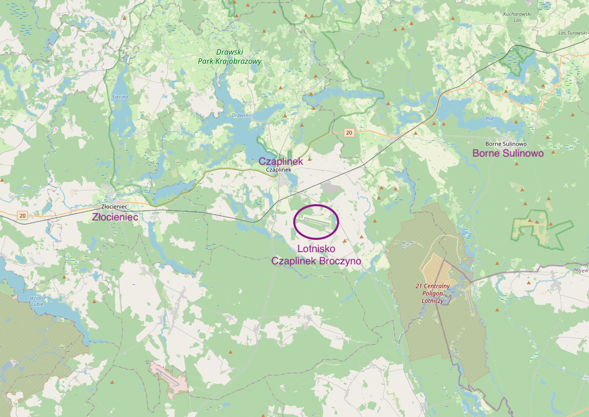
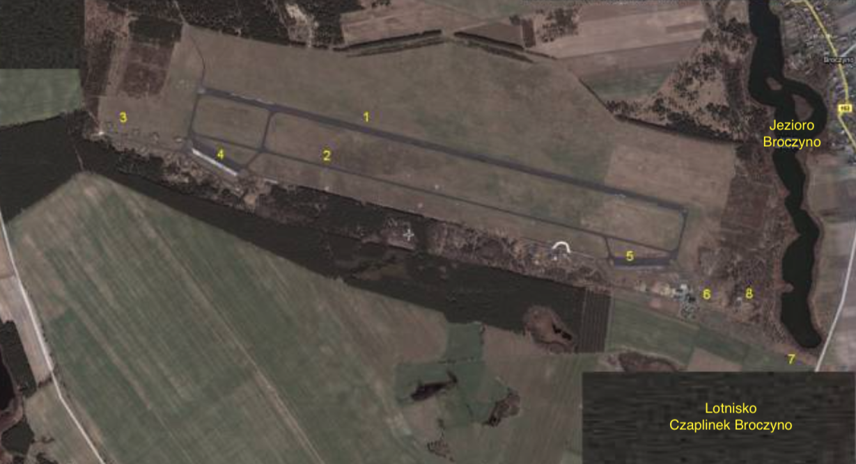
Photo description: 1 RWY. 2 Main taxiway. 3 Aircraft centering zone. 4 Western PPS. 5 Eastern PPS. 6 Airport facilities. 7 Access to the airport. 8 MPS.
Czaplinek Broczyno Airport.
The airport is known among people interested in aviation as Broczyno Airport, but since the town of Broczyno is small, and only 7 km away is the large and well-known town of Czaplinek, therefore for the purposes of this article we will use the name Czaplinek Airport.
The airport was built in the 1950s. It was operated as a spare by the Polish Military Aviation until 1991. Currently (2008), after almost 20 years of non-existence, thanks to the Association, efforts are being made to reactivate it as a civilian airport and a recreation and sports center.
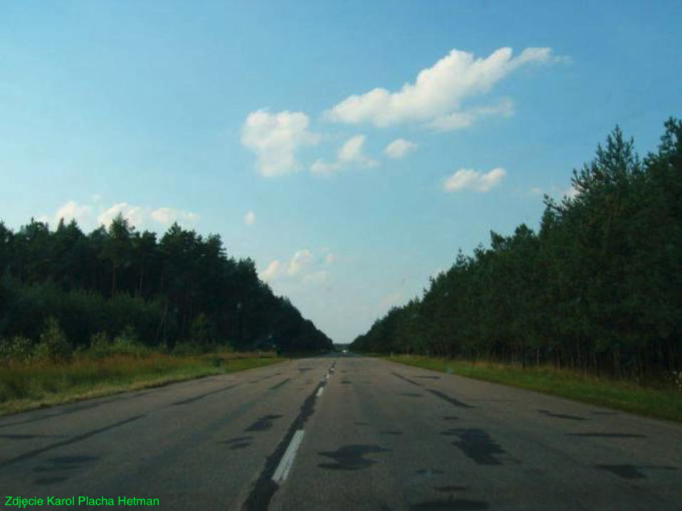
The airport is on the list of the Civil Aviation Office, in the category - other place for takeoffs and landings - which also means the maximum take-off weight of an aircraft is up to 5,700 kg. There is no radio frequency allocation. Airport coordinates; Latitude 53 degrees 31 minutes 11 seconds N, Longitude 16 degrees 17 minutes 00 seconds E, Elevation (height above sea level) 155 m (508 ft). DS (RWY) concrete with asphalt surface, dimensions 2,300 m x 30 m, orientation 10/28 (exactly 104 degrees / 284 degrees).
Czaplinek and the surrounding area – History.
The oldest traces of settlement, dating back 2,500 years. They were discovered on Bielawia Island on Lake Drawsko and in Stare Drawsko. At the beginning of our era, there were Pomeranian Slavs here, more often called Pomeranians. In the 10th century, Pomerania was annexed to the State of Polans, led by Prince Mieszko I. Pomeranians gravitated towards the Polish Crown for many centuries. This was related to constant invasions of warlike peoples inhabiting today's Denmark and northern Germany. Pomeranians preferred the authority of the Polish Crown, because it always gave them great sovereignty.
After the famous Congress of Gniezno in 1000, a bishopric was established in Kołobrzeg and the area came under its jurisdiction. This fact is often forgotten by some historians who do not recognize the possibility of uniting the lands not only under one ruler, but also under one religion. The Pomeranians, through the Noteć River, bordered the Polans, the cradle of Polish statehood.
But already in the 11th century, tribes from the West began to invade Pomerania again and at the end of the reign of Bolesław the Brave, Poland lost power over them. Pomeranians were fought and murdered, they sent petitions to the Rulers of Poland. Only Bolesław Wrymouth, after dealing with the invasion of Emperor Henry V, at the beginning of the 12th century, reincorporated Pomerania into Poland. At that time, Czaplinek was already a stronghold, probably fortified with an earth and wooden palisade. The period of District Poland and the great distance of Pomerania from Wawel caused the Republic of Poland to neglect the affairs of Pomerania.
The 13th century was a period when knightly orders that actively participated in crusades to the Holy Land were "looking for new work". Therefore, in the fall of 1286, Przemysław II, Duke of Greater Poland, pretender to the Polish Throne, brought knights of the powerful Order of the Temple of Jerusalem, called the Templars for short, to this area. They built the Temple Castle (tempelborg) next to the existing fishing settlement of Czaplinek. The Templars supported pilgrimages of the faithful to the Holy Land.
Przemysław II, as King of Poland and Ruler of Pomerania, was murdered in 1296, which adversely affected the development of Pomerania. The Brandenburg knights entered these areas.
The events of 1305 led to the liquidation of the Templar Order in France and then throughout Europe. In 1345, the Templar estates in Czaplin were taken over by the Knights of St. John. 10 years later, the Temple Castle burned down, burned down by the Prince of Szczecin because of the sympathy of the Order of St. John with the Margraves of Brandenburg. The monks rebuilt it, but on the isthmus located 6 km from the city between lakes Drawsko and Żerdno, known as Drahim.
You should also know that these areas were located on an important trade route, called the salt route. The trail connected the town of Kołobrzeg with Greater Poland and the rest of the Republic of Poland. Casimir the Great bought Czaplineki from the Knights of St. John and in 1368, he accepted the Order of St. John under the protection of the Crown. At the same time, the Drawsko Treaty was to end the Polish-Brandenburg war and make Drahim a fief of Poland again. However, there was no peace on the border, and the rich Order of Hospitallers was not a faithful tributary. After the death of King Casimir the Great in 1370, the Hospitaller-Pomeranian War broke out on the Drahim border. The Pomeranians devastated the area, but they did not conquer Drahim. The Knights of St. John began to make arrangements with the Teutonic Order to break Drahim away from Poland. They were prevented from doing so by Władysław Jagiełło, who in 1407, while touring western Poland, set out for Drahim. He called on the Knights to submit, and when they did not obey, he sent his knights who captured the castle. The king expelled the Order of Hospitallers and placed the seat of the Polish Starosty of Drahim in the castle. It came in handy when, in 1410, knights from the West went to Grunwald, because Drahim's crew did not let everyone through. The Teutonic Knights did not stop in their pursuit of Drahim. They quarreled among Pomeranian families. In 1422, at their instigation, the townspeople from nearby Drawsko attacked and briefly captured the Drahim Castle. This event is related to the legend of the fisherman Paweł Wasznik, who, according to the chronicles, had a chamber in Drahim. He threw a net from the window, and the Polish relief force entered the stronghold. Today, a fisherman's monument stands in the town square to commemorate this history.
This political situation, which lasted from the mid-15th century to the early 17th century, is often referred to as the 150-year frontier war. Throughout the entire period of the starosty's existence, Czaplinek remained in the shadow of Drahim, performing a subservient function in relation to the castle.
The next events that decided the fate of the Czaplinek Land began on July 21, 1655, with the Swedish invasion. The invading troops crossed the border of the starosty near Siemczyn, and after plundering the town and pogroming the inhabitants, they set off towards Wałcz. In 1657, after a series of failures, the main Swedish forces withdrew from Poland, burning Drahim behind them. John Casimir, under the Bydgoszcz Treaty, gave the starosty to the Brandenburg side as a pledge for recruitment during the ongoing war. Despite strenuous efforts, led by, among others, Polish Hetman Stanisław Rewera Potocki, the starosty could not be regained until the first partition of Poland in 1772, after which these lands came under Prussian rule.
The 17th century turned out to be beneficial for Czaplinek, among other things, due to its significant economic and urban development. At that time, the city had one of the largest cloth craft centers in Western Pomerania, mills, windmills, a sawmill, and a brickyard. Czaplinek, however, was not spared from great fires that destroyed the town almost entirely. In the second half of the 18th century, Drahim gradually lost its importance in favor of the city, and the castle fell into ruin.
At the end of the 19th century, a railway line was connected to the city. The construction of roads, cobbled streets, a gas network began, and a post office and telegraph were established. During World War II, a labor camp for Soviet prisoners of war was established in Czaplinek and its surroundings, and a large group of Poles were employed by the Germanic occupiers as forced laborers (slaves). The city was located on the line of Germanic fortifications called the Pomeranian Wall and was defended by selected military units. After breaking through the main positions of the Pomeranian Wall, units of the 7th Regiment of the 3rd Infantry Division attacked towards Czaplinek. By order of Major Stanisław Rusijan, three battalions supported by artillery units captured the city on March 3, 1945. After about three hundred years of partition, these were the first Polish soldiers. Pursuant to the great agreements of this world, these areas returned to Poland.
After World War II, the town of Czaplinek slowly lost its agricultural character, serving as an agricultural base, and the main industry was based on electronics and tourism.
Czaplinek commune.
The Czaplinek commune is located in the south-eastern part of the West Pomeranian Voivodeship, in the center of the Drawskie Lake District - a land of outstanding landscape and natural values, at the same time of strategic ecological importance (sources of the Przymorze rivers and the Odra basin). Administratively, it belongs to the West Pomeranian Voivodeship, with its seat in Szczecin, and the Drawsko County, with its seat in Drawsko Pomorskie. It covers an area of 36,472 hectares and was inhabited by 12,201 people in 2008. There are 48 towns in the commune, which are part of 29 village councils. The seat of the commune's self-government authorities is located in Czaplinek. The land is; 40% agricultural areas, 38% forests, 10% lakes.
The National Road No. 20, Stargard Szczeciński - Gdynia, the provincial road No. 163 of national importance Wałcz - Kołobrzeg, the provincial road No. 171 from Czaplinek to Bobolice and the provincial road No. 177 from Czaplinek to Wieleń run through the area of the commune and the city of Czaplinek.
The commune has a railway connection Szczecinek - Runowo Pomorskie - Szczecin, enabling access to most cities in Poland. It also has convenient bus connections with: Szczecin, Poznań, Turek, Koszalin, Kołobrzeg, Słupsk, Warsaw.
The town of Broczyno.
South of Czaplinek is the town of Broczyno. The airport is located on its territory. Broczyno is a village located in the West Pomeranian Voivodeship, in Drawsko County, in the Czaplinek Commune. In the period 1975-1998, the town belonged to the Koszalin Voivodeship. It is located on the lake of the same name, Broczyno. It is approximately 7 km from Broczyno to Czaplinek. Provincial Road No. 163 runs through the town, connecting Czaplinek with Wałcz, and is of national importance.
The population of Broczyno in 2007 was 471 people. Numbering zone 94. Postal code 78-550. ZDR license plates. SIMC number 0304728. SIMC (System of identifiers and names of places) - a system that is a component of the National Register of Official Territorial Division of the Country (TERYT).
The area is typically agricultural, with a flat terrain. Many palaces and manors were built in the immediate vicinity, and some of them have survived to this day. In the village itself, several dozen houses from the 19th century have been preserved, including half-timbered ones. There is a neo-Gothic palace here, with a park and a manor house. There is a primary school in Broczyn. There is a parish church here. Our Lady Help of Christians, also known as the church of the late. Jadwiga and Szczepan Adamczyk. A Roman Catholic church belonging to the Barwice deanery, Koszalin-Kołobrzeg diocese, Szczecin-Kamień metropolis. It is a 16-sided rotunda with a diameter of 15 m with an adjacent semi-circular apse, the whole thing is faced with field stones. The rotunda was built in the 1980s. Next to the rotunda there is a bell tower with a bell from 1595, the remains of the front temple.
Czaplinek Airport.
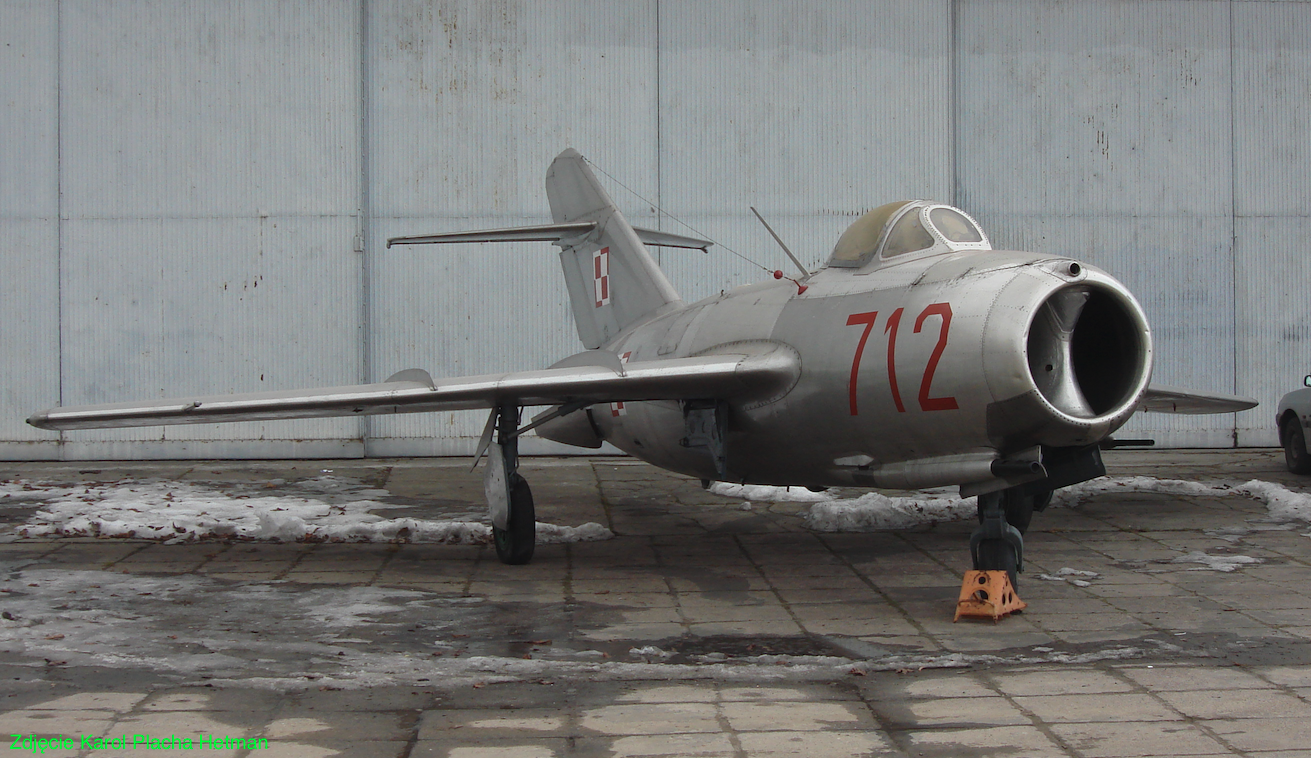
The airport was built in the second half of the 1950s as a backup airport for the 6th Fighter-Attack Aviation Regiment stationed in Piła. Czaplinek Airport is a typically Polish airport. From the very beginning, the airport was built to operate PZL Lim-1/2 turbojet aircraft. The airport was systematically renovated. It gained its final shape in the 1970s.
Czaplinek Airport as an alternate airport was a typical military airport. The difference was that the flight insurance infrastructure was developed as needed. That is, communication, radar, lighting, field workshops. The command and maintenance of such an airport, in readiness, rested with KLZ (Alternate Airport Command). A platoon of soldiers was subordinated to the commander and head of the KLZ, and they were assigned to serve from all specialties and subunits of the regiment. There was basic equipment at KLZ enabling the reception of the first batch of landing planes. Successive air and wheeled missiles followed the flying planes in front of and behind them, and gradually took over the role of the KLZ. Twice a year, during the so-called spring and autumn passages, all equipment in the KLZ was inspected and maintained. This also concerned fuels stored at the airport in MPS warehouses. (It was about the content of liquid "I"). The issue of weapons was a bit more complicated; ammunition, bombs and other means of air attack. Not all spare airports had permanent bomb depots.
There is an opinion that one alternate airport was better than the other. However, this is not related to the service performed there, but to the social and living conditions and the possibility of spending time free from service.
For over 30 years, apart from the 6th PLM-Sz (6th PLM-B), other Regiments were temporarily based at the airport. They had Lim-1/2, Lim-6, Su-7 from Bydgoszcz, Su-20 and Su-22 aircraft. Other aircraft landing at Czaplinek Airport include: Li-2, Il-14, PZL Wilga, PZL TS-8 and, above all, PZL An-2.
Due to socio-economic changes in Poland, in 1991, the Polish Army stopped using the Czaplinek Airport. KLZ forces gradually decreased. The airport became redundant and was handed over to the local government relatively quickly.
Machliny Airport Road Section.
Only 7 km from the airport, on the provincial road No. 163, towards Wałcz, there is an Airport Road Section (DOL). The exact coordinates are; 53 degrees 27 minutes 26 seconds long N, 16 degrees 22 minutes 20 seconds long E. Distances; 14 km to Czaplinek and 22 km to Wałcz. DOL is located in the forest in the Krajeńskie Forests.
This is one of many DOLs in this region of Poland. Please remember that practically until the end of operation; MiG-21 fighters (2003), MiG-29 (until 2020), Su-22 fighter-bombers (until 2022), takeoffs and landings of Polish combat aircraft from DOL was the norm and one of the most important elements of pilot training. Lockheed Martin F-16 multi-role combat aircraft completed their first training at DOL in 2023.
Road Section of the Nowe Laski Airport.
Also on the Provincial Road No. 177 Czaplinek - Mirosławiec there is DOL Nowe Laski. Currently (2009) also not used. In a straight line, Czaplinek Airport - DOL Nowe Laski is 16 km away.
Infrastructure of Czaplinek Airport. 2009 year.
The airport is on the list of the Civil Aviation Office, in the category - other place for takeoffs and landings - which also means the maximum take-off weight of an aircraft is up to 5,700 kg. In practice, the possibilities are much greater and landing a machine weighing 20-30 tons is realistic. The airport has no radio frequency allocation. Approach to the runway clear of obstructions as defined. In the area adjacent to the airport there is an 80 m high measuring mast. The red and white mast does not constitute an obstacle to operating from the airport in Broczyno. Note: no night mast lighting.
The airport has a typical alternate airport layout. The airport has an area of approximately 200 hectares. Airport coordinates; Latitude 53 degrees 31 minutes 11 seconds N, Longitude 16 degrees 17 minutes 00 seconds E, Elevation (height above sea level) 155 m (508 ft).
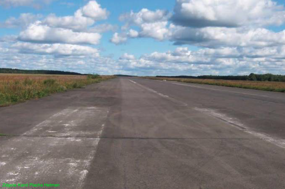
RWY concrete with asphalt surface, dimensions 2,300 m x 30 m, orientation 10/28 (exactly 104 degrees / 284 degrees). It has an area of 69,000 square meters. RWY is in very good condition.
DK (taxiways) with a length of approximately 2,700 m and an area of approximately 41,000 square meters. They have an asphalt surface and are in good condition. There are two CPPS at the airport; eastern and western, with dimensions of 220 m x 60 m and an area of 13,200 square meters each. They have a concrete and asphalt surface. Their condition is good. In the western part of the airport, there are 10-12 individual, centrally located stands (stators) for aircraft, protected on three sides by earth embankments. In one of the embankments there is a small shelter with dimensions of 1.5 m x 1.5 m x 5 m. Aircraft maintenance equipment was stored in this shelter.
In the eastern part there are several buildings for the basic airport facilities. Access to the airport is provided by an asphalt road from Broczyno. The airport borders Lake Broczyno from the east. There are small forests to the south, west and partly to the north. The Salesian Educational Center is located in the former social and living facilities of the airport.
Czaplinek Flying Aviation Association. 2007 year.
Aviation is not for brave people. Aviation is for stubborn people. - This sentence perfectly suits people who are interested in Czaplinek Airport. A group of enthusiasts have been making efforts for several years to reopen the airport, which has been closed for about 20 years. In 2007, they established the Czaplinek Flying Aviation Association in Czaplinek. The association has approximately 30 members. The president is Mr. Wojciech Marcewicz. Wojciech Marcewicz - President of the Czaplinek Flying Association. street Drahimska 47, 78-550 Czaplinek. tel. 602 461 267, 506 434 216. fax: 094 375 5232. e-mail: ager1@o2.pl.
The objectives of the Association are as follows; Registration of Czaplinek Airport by the Civil Aviation Office. Restoring the functions of the airport in Broczyno and adapting it to the requirements of tourist, sports, rescue and emergency aviation. Training in flying techniques and air traffic control. Organizing training and shows related to aviation, hang gliding, ballooning, parachuting and modeling. Organizing sports competitions, rallies and air picnics. Organizing a social movement around the Association's goals. Collecting financial, material and technological resources and creating special-purpose funds. Searching for investors from the aviation industry who want to invest in the airport and the Czaplinek commune.
The commune authorities, which own the facility, are supportive of the initiative. Of course, we are not talking about passenger traffic here. This is simply unrealistic. The facility, if built, will serve small aircraft enthusiasts for sports, tourist, business and training purposes. The Mayor of Czaplinek, Barbara Michalczik, is also a supporter of the Czaplinek Airport. He claims that opening the airport for tourist and business purposes is a step in the right direction. The Mayor said - We are 90 percent prepared. There is a runway in good technical condition and associated facilities. Above all, there were people who took up the effort to reactivate the airport. There is no airport in the commune's spatial development plan, but efforts have already been made to improve it. Recently, the Association became the tenant of this facility.
On July 17-19, 2009, the Association organized the Czaplinek Air Days aviation event at the Czaplinek Airport. It promoted both the Airport and the City. The picnic was certainly not the size of other events of a similar type, but a start was made and that is important. It was the first event of this type at this airport. The association managed to organize another picnic in July 2010. The former airport in Broczyn is a place of rest, recreation and sports.
Currently (2008 year), there are two registered airports in the West Pomeranian Voivodeship, focused on handling small business and sports-tourist class aircraft. One of them is in Dąbie, and the other in nearby Borne Sulinowo. But the grass DS in Borne Sulinowo is unable to accommodate larger planes. Virtually any machine can unload at Czaplinek Airport. Mr. Wiesław Filosek, a member of aviation associations in Borne Sulinów and Czaplinek, claims that many pilots from Western Europe would be happy to come to rest in these beautiful regions of the Republic of Poland. Foreigners often ask about the landing and take-off conditions at Czaplinek Airport. A small tourist plane flies from Berlin to Czaplinek in about 40 minutes. There are still many obstacles ahead of the Association, but looking at its achievements, we are convinced that they will achieve their goal. We personally support this initiative very much and keep our fingers crossed for it. For a simple reason. There is an airport and we should not lose this property. There is a facility that currently costs PLN 100-200 million. Of course, we have no illusions. It won't be a commercial airport accepting Boeing planes, but a Skytuck, why not.
And one more note; There are investors who would like to build a wind farm in this area. Only they are not Poles. Profits will flow abroad. Polish Energy Grids must buy energy from such an investor because it is so-called green energy. There is also more and more talk about the negative sides of wind farms. In one of the Polish municipalities, windmills that had previously been dismantled in Germany were built because they were noisy and reduced the bird population. There is no shortage of electricity in Poland, since the current government of Mr. Donald Tusk is trying to sell out the Polish Energy Industry.
Actions at the airport.
In May 2009, an action was carried out at Broczyno Airport to prevent the spread of rabies among wild animals. The actions were carried out with the help of an agrotechnical services company with An-2 aircraft. This action is carried out once or twice a year. It covers the entire area of the West Pomeranian Voivodeship. The vaccine is distributed through fish soaked in a special antiviral preparation. Veterinary services warn that the preparation is harmful to humans, and that wild animals will not eat fish touched by humans. The planes dropped automatically with simultaneous monitoring. Several An-2 aircraft, Antonov designs and two Cessna aircraft took part in the operation.
Written by Karol Placha Hetman