Sanok 2023-05-05
Sanok railway station.
Geographic coordinates: 49.552N 22.211E. Address: Dworcowa Street, DK No. 28.
City of Sanok.
Sanok is a city in Poland in the Podkarpackie Voivodeship. The area of the city is 39.09 square km. The city is one of the highest located cities in Poland and with a very large amplitude of altitude, from 278 to 668 m above sea level. The population of the city is 37,113 people (2019). Sanok also has the full name of the Royal Free City of Sanok. The city was founded in 1339 by Prince George, from the Piast family. The city is located in the Carpathian Mountains, in the valley of the San River. Sanok is the furthest city to the south-east of Poland. Sanok is a large industrial center with a developed chemical and automotive industry. Railway wagons, trams, buses were produced in Sanok, and now military trucks are produced. Near Sanok, in the village of Bóbrka, there is the world's oldest oil mine. The patron of the city is Archangel Michael, and since 2006, also Saint Zygmunt Gorazdowski.
As a result of the first partition of Poland in 1772, Sanok and the Land of Sanok were occupied by Austria and became part of the Kingdom of Galicia and Lodomeria. The Austrians destroyed the city, so the authorities of the region (circle) were moved to Lesko. In 1798, Sanok was partially rebuilt and the councilors returned to Sanok. The Austro-Hungarian occupation stopped the peaceful development of Sanok for many years. The development of the city was subordinated to military goals.
The construction of a railway line from Chyrów through Zagórz and Łupków to Hungary in 1872 and the construction of a section from Zagórz through Sanok to Jasło in 1884 were of great importance for the development of Sanok.
On November 1, 1918, the authorities in the city were taken over by Poles. The Republic of Poland was reborn. In 1939, Sanok had about 18,000 inhabitants. The 2nd Podhale Rifle Regiment, which was part of the 22nd Mountain Infantry Division, was stationed in the Sanok garrison.
As a result of the attack of the Germans and the Soviets on Poland, 40% of the city's inhabitants lost their lives. By June 1941, through Sanok, on the San River, the German-Soviet border was established. During the Second World War, Sanok was the seat of the Home Army District Headquarters. On August 3, 1944, Sanok was occupied by Soviet troops of the 1st Ukrainian Front. The Soviets deceitfully disarmed and arrested Home Army soldiers. The Soviet terror began and many Polish soldiers lost their lives.
After World War II, industry developed in the city; Sanok Bus Factory "Autosan" and Zakłady Przemysłu Gumowego "Stomil" and others, which employed thousands of workers. In 1970, Sanok had 22,000 inhabitants, and in 1985, the number exceeded 40,000 inhabitants.
Car communication.
Public and suburban transport is operated by MKS Sanok. In March 2019, the construction of a new bus station building, connected by a covered flyover with the railway station, was completed. In the area of Sanok there are: National Road No. 28 (Zator - Medyka) - Sanok Bypass. National road No. 84 (Sanok - Krościenko). Provincial road No. 886 (Domaradz - Zabłotce).
Air Transport.
In Sanok, there are two landing pads for SP ZOZ Polish Medical Air Rescue helicopters. The Sanok Airstrip - Base is located on Biała Góra on the right bank of the San River. Helicopters of the Sanok LPR service the entire Podkarpackie Voivodeship, mainly the Bieszczady Mountains, providing quick medical assistance to the inhabitants of the province and tourists visiting the region. LPR has a Eurocopter EC135 helicopter, which in mid-August 2010 replaced the worn-out PZL Mi-2 helicopter. The airstrip was rebuilt in 2012.
The second Sanok helipad - Helicopter Hospital, is located at the Specialist Hospital in the immediate vicinity of the Hospital Emergency Department, which can also receive helicopters both during the day and at night. The address is Stawiska Street, in the southern part of the city.
Galician Transversal Railway.
The so-called Galician Transversal Railway runs through Sanok, running latitudinally along the chain of the Carpathians. At the time of its creation, it was entirely within the Austro-Hungarian Empire. Its length was 768 km. A road was built along the railway line, which is now the National Road No. 28. The circular road was put into use in 1851.
The name Transversal comes from the Latin word trans versalis - transverse, because it crosses the most important rivers of the northern Carpathians. The idea was for the railway line to connect the already existing short railway sections and create an uninterrupted railway line. The main intention was to create an alternative railway route to the main Kraków-Lviv railway route, called the Galician Railway named after Karol Ludwik. One of the goals was a military goal, in case of a war between Austria-Hungary and Muscovy. The line was also supposed to stimulate the development of mountain areas.
Before the start of the Galician Transversal Railway project, there were already four railway routes. The first section was: Zagórz - Krościenko - Chyrów - Przemyśl. It was a part of the First Hungarian-Galician Railway Slate - Przemyśl, which was launched in 1872. The second section was the Dniester Railway: Chyrów - Sambor - Stryj, which was also launched in 1872. The third section was the Railway of Archduke Albrecht: Stryj - Dolina - Stanisławów, which was launched in 1873. The fourth section was the route: Nowy Sącz - Stróże, which was a fragment of the Tarnów - Pławiec line, and was launched in 1876.
As part of the Galician Transversal Railway in 1884, railway lines with a total length of 577 km were opened. There were three episodes. The first section: Czadca - Zwardoń - Żywiec - Sucha - Chabówka - Limanowa - Nowy Sącz, with branches such as Sucha - Skawina - Podgórze (now Kraków Płaszów) and Skawina - Oświęcim. The second section: Stróże - Jasło - Sanok - Zagórz, with a branch to Gorlice. The third section: Chryplin (near Stanisławów) – Buczacz – Czortków – Husiatyn.
The final stations were Czadca in Hungary (now in Slovakia) and Husiatyn (now in Ukraine). The entire trail was 768 km in total. After the Great World War, most of the route of the Galician Transversal Railway found itself on the territory of the reborn Republic of Poland.
After World War II.
After World War II, the Polish part of the railway route ended at the Olszanica station. In 1951, the borders between Poland and the Ukrainian Republic (CCCP) were corrected, then the Polish route reached Ustrzyki Dolne and Krościenko.
Currently, the Transversal Railway line is located in three countries: Poland, Ukraine and Slovakia and is not a homogenous organism. In Ukraine, most of the lines have been reforged into wide gauge, 1,520 mm. The section to Chyrów remained normal-gauge. The Stanisławów – Buczacz section was physically liquidated by the Germans in the summer of 1944 and has never been rebuilt. To Slovakia, Polish trains reach Medzilaborce, passing through the Lupkowski tunnel.
Railway line No. 102.
Railway line No. 102; Przemyśl – Malhowice, has a length of 12,380 km, is single-track, electrified. Further on, the line leads to the closed border crossing Hermanowice – Chyrów (in Ukraine). It was the route Krościenko - Chyrów - Przemyśl. The crossing was completely closed in 1994. The track still exists. The line is currently used to transport wagons and locomotives to the holding tracks located at the Przemyśl Bakończyce station. The line was built in 1872, as part of the First Hungarian-Galician Railway, connecting Przemyśl and via the Galician Karol Ludwik Railway, Lviv with Sátoraljaújhely in Hungary and Budapest. During the period of People's Poland, the normal gauge track preserved on the Soviet side allowed for passage from Krościenko through Starzawa, Chyrów and Niżankowice to Malhowice. Long-distance trains to Bieszczady ran along this route. These trains were unavailable to CCCP residents. Soviet soldiers stood on the steps of the carriages and watched over passengers and Polish railwaymen. In 1963, an intergovernmental agreement was concluded. It allowed to control passengers and railwaymen on trains in CCCP. There was no border check and no need to have passports, but an ID card was necessary. In 1994, the movement of passenger trains was stopped. No agreement was concluded with the government of Ukraine. In 2022, a renovation was carried out on the Polish side. On the section from Krościenko towards the border, tourist trolleys are operated. At the Chynów station, the tracks were probably made wide.
Railway line No. 108.
In Poland, line No. 108 Stróże - Krościenko has a length of 160,500 km. It is a single-track, non-electrified line. Only the 47 km section, Stróże - Jasło, is electrified. Electrifications were built in 1988. Also the route No. 96 Tarnów - Leluchów is electrified and belonged to the Galician Transversal Railway.
Route No. 108 is technically difficult and only short sections allow for a speed of 80 km/h. Many sections allow the train to run at a speed of only 40 km/h. Since 2017, necessary repairs have been started on route No. 108. New platforms at stops are being built. Over 26 km of tracks were replaced. These repairs are ongoing, and their goal is to increase the speed of passenger trains.
For the Bieszczady region, railway connections to Jasło and Rzeszów are important, because there is already electric traction and EMUs (electric traction sets) from Przemyśl, Tranów and Kraków arrive. The electrification program of line No. 108, up to Krościenko, has not yet been implemented. There was talk of electrification plans in the 1980s. There is a chance that route No. 108 will be electrified by 2027.
For the inhabitants, it would be important to build the Jedlicze - Szebnie or even Krosno - Przybówka link, which would significantly shorten the road to Rzeszów. The connection to Rzeszów is very important because Pendolino trains already reach Rzeszów, so you can get to Kraków, Warsaw, Iława, Tczew, Gdańsk, Gdynia and Kołobrzeg.
It is worth mentioning here that never in the history of the Galician Transversal Railway has there been such a passenger train that would cross the entire route.
In 2006, Sanok lost fast trains. Only a small local traffic remained, which was used more often by tourists than by residents. Railbuses usually ran only to Jasło, Zagórze and Rzeszów.
In 2010, it was planned to completely liquidate passenger rail traffic, putting forward the argument of unprofitability. In 2013, all passenger traffic on the Nowy Zagórz - Krościenko section was suspended. Since 2016, several trains have been renamed tourist, because they started running only on weekends, i.e. not for residents. However, there is always a chance for normal passenger traffic to return.
Passenger traffic is handled by Przewozy Regionalne (PolRegio), local trains, and fast trains by TLK and InterCity. In 2016, the station in Sanok served up to 50 passengers a day.
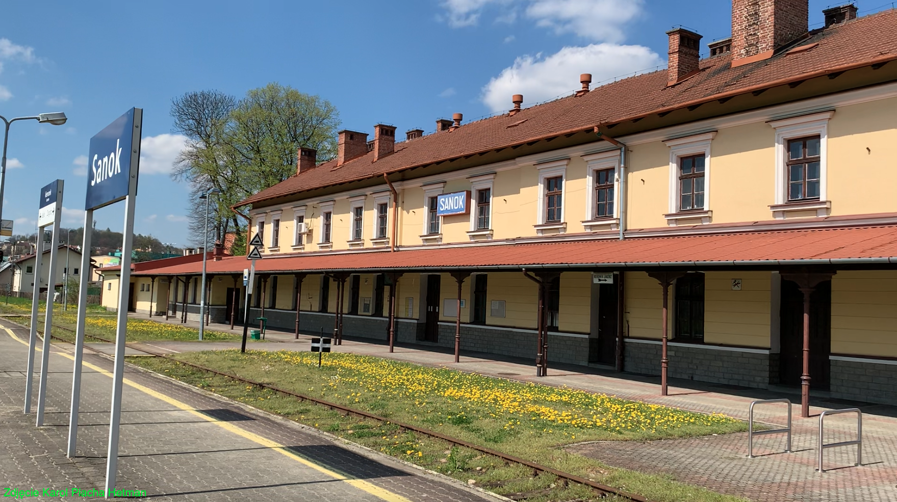
Sanok railway station.
The station is located on the railway line No. 108 Stróże - Krościenko. She was launched in 1884. At the beginning of the 20th century, the Sanok station served the following passenger trains: Stróże - Chyrów, Stróże - Zagórz, Krosno - Zagórz, Sanok - Nowy Łupków - Miedzilaborce. The station was used by the "Sanocka wagon factory". In 1967, the square in front of the station became the bus station of the PKS company.
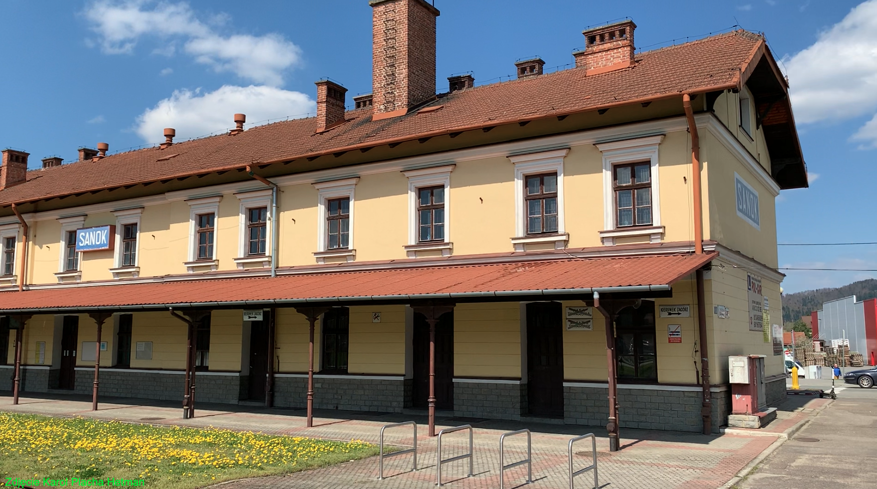
The station is a typical Galician building, two-story, without a basement, covered with a gable roof covered with red tiles. The attic is developed. From the side of the station level, next to the building there is a roof supported on cast-iron supports and covered with a tin roof. From the outside, the building is very well-maintained, with a bright yellow facade. The building is not accessible to travelers and there are no ticket offices inside. Travel toilets are traditional Toj-toj cabins. There is a car park at the station, as well as parking for bicycles.
The last renovation of the station was completed in 1994. Inside were; three cash registers, the "Semafor" bar, a waiting room and flats for railwaymen's families. In 2005, the station was closed to travelers due to a significant reduction in the number of trains running. In 2015, the station was entered into the municipal register of monuments.
At that time, the bus station was moved to the southern side of the railway station, where a new bus station building was built (ul. Kazimierza Lipiński, DK No. 84).
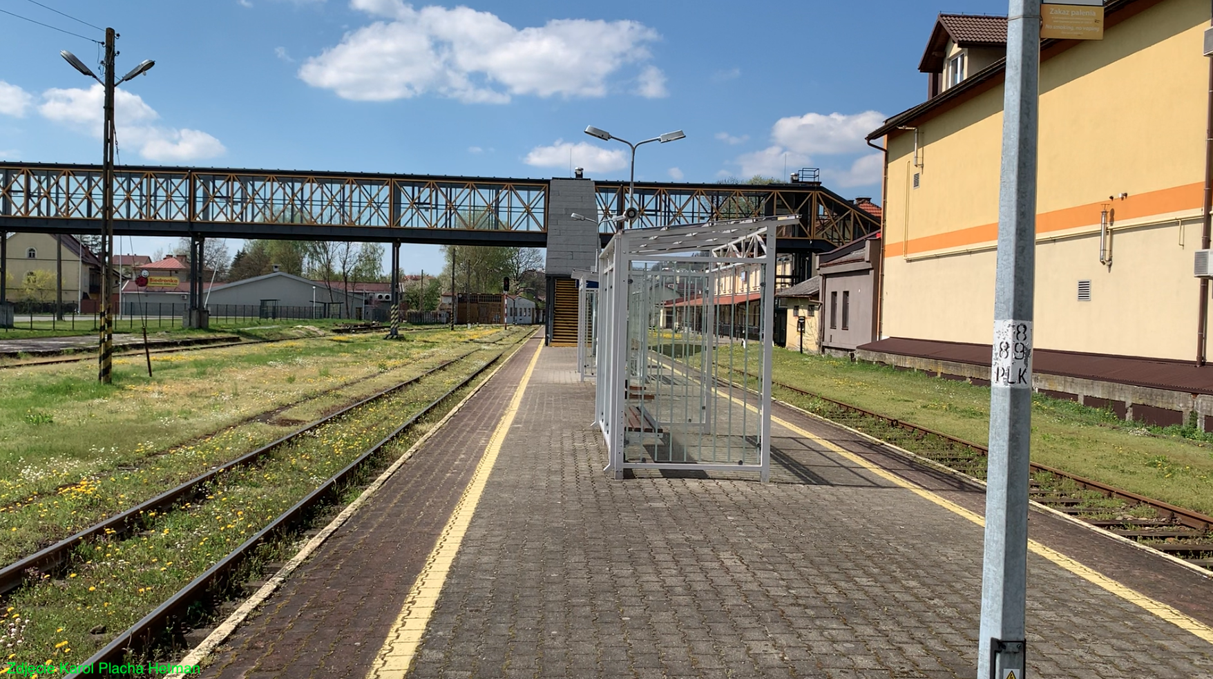
The station has one island platform with two platform edges. Platform 1 is 220 m long. The platform is of the low type and has a height of 0.3 m from the top of the rail. The surface of the platform is made of concrete cobblestones. On the platform there are benches, bus shelters, waste bins, sound system, street lighting.
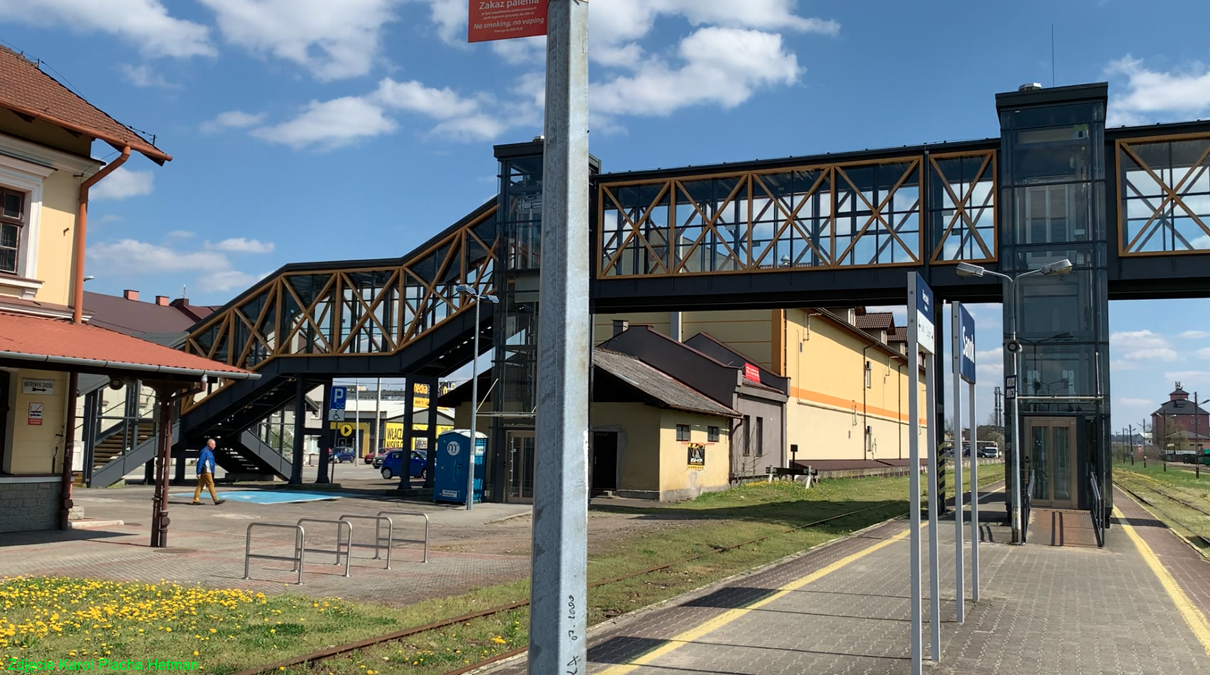
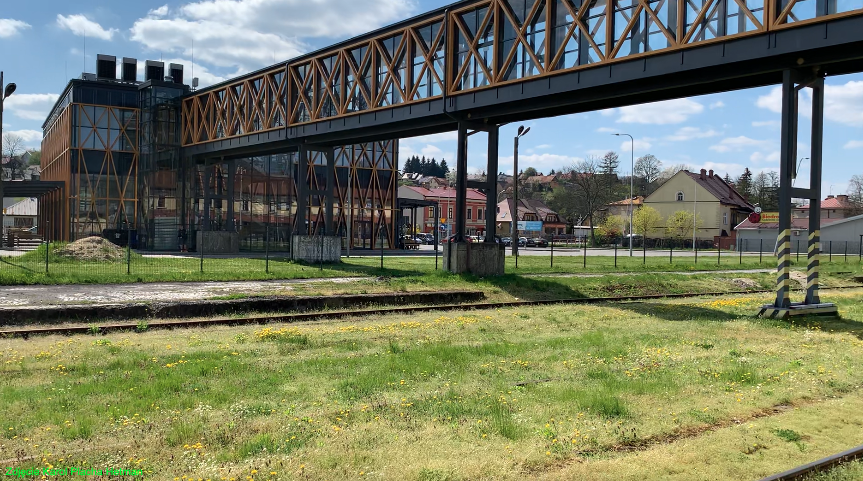
Access to the platform and the bus station is provided by a footbridge over the tracks, which was put into operation in 1982. Its contractor was the factory "Autosan". In 2019, the footbridge was completely renovated. Currently, it is a covered flyover with stairs and lifts for the disabled and travelers with larger luggage. The flyover is glazed.
Currently (2023) there are 6 tracks at the station. Tracks 1 and 2 are at Platform 1. Track 3 is at the freight ramp and is in use. There are also railway service buildings in the station area. Former railway warehouses are used by commercial establishments. The railway signaling at the station is with traffic lights. The station is very neat.
In 2015, the station served about 20 passengers per day. In 2020, the station served up to 50 passengers per day. In May 2023, several trains could depart from the Sanok station. Directions: Gliwice - 1 train. Jaslo - 6 trains. Katowice - 1 train. Kłodzko City - 1 train. Krakow Main - 5 trains. Lupkow - 2 trains. Opole - 1 train. Tarnow - 10 trains. Ustrzyki Dolne - 3 trains. Zagorz - 3 trains. The TLK "Wetlina" train runs on an extended route from Kłodzko Miasto to Zagórz. Thanks to this, we can get to the Bieszczady Mountains directly from Kłodzko, Nysa, Opole, Gliwice, Zabrze, Katowice and of course Krakow and Tarnów. The train leaves Kłodzko Miasto at 14:10, so it takes just over 9 hours to travel the entire route. The journey from Sanok to Kraków Główny takes about 5 hours. Relationships are handled by SZT belonging to SKPL.
Written by Karol Placha Hetman