Ostrów Wielkopolski 2022-12-28
Ostrow Wielkopolski Airport, Michalkow.
Geographic coordinates: 51.701N 18.847E. Elevation 143 m above sea level.
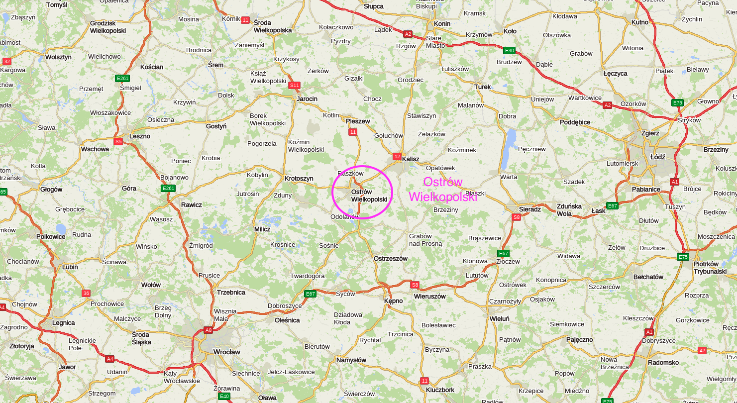
The city of Ostrow Wielkopolski.
Ostrów Wielkopolski is a city in Wielkopolska, in the Wielkopolskie Voivodship. The city has an area of 41.90 km2. In 2020, Ostrów Wielkopolski had 71,560 inhabitants and the city was ranked 53rd among the most populous cities in Poland. The city received city rights in 1404 and they were confirmed in 1713. The patron saint of the city is St. Stanisław from Szczepanów.
The town was called Ostrów, and then Ostrów Kaliski (1919-1920). The name Ostrów Wielkopolski was given in 1920, when Wielkopolska returned to Poland. Ostrów Wielkopolski is located close to Kalisz, just 25 km away. From Ostrów Wielkopolski to: Poznań is 120 km, Wrocław is 100 km, Warsaw is 275 km, Krakow is 310 km.
Geographically, Ostrów Wielkopolski is located in the South Greater Poland Lowland. Traces of the settlement of Ostrów Wielkopolski date back to the 11th century. In the fifteenth century, the stronghold had city rights, but as a result of numerous wars and fires, the stronghold fell into decline. Thanks to the efforts of Jan Jerzy Przebendowski, in 1713, Ostrów again received city rights under the Magdeburg law, combined with the issuance of numerous royal privileges. The vicinity of the city is one of the main natural gas extraction areas in Poland.
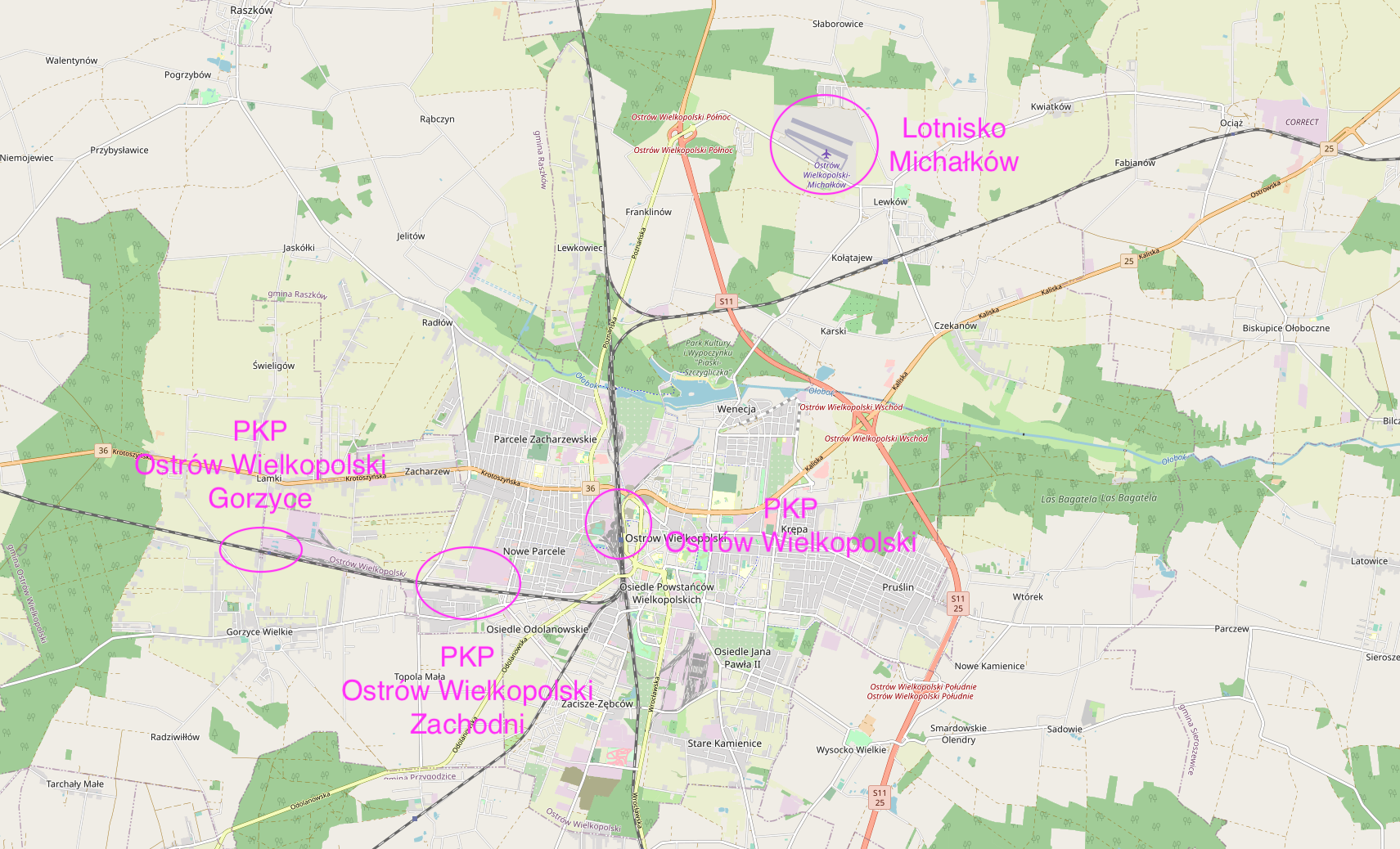
Ostrow Wielkopolski road transport.
Ostrów Wielkopolski is an important road junction in Poland. The S11 Expressway and the city ring road: Strugi – Ostrów Wielkopolski – Franklinów run next to the city. (National Road No. 11 Kołobrzeg - Koszalin - Piła - Poznań - Ostrów Wielkopolski - Kępno - Lubliniec - Bytom). National Road No. 25 Bobolice - Bydgoszcz - Konin - Kalisz- Ostrów Wielkopolski - Oleśnica. National Road No. 36 Ostrów Wielkopolski - Krotoszyn - Rawicz - Lubin - Prochowice. Provincial Road No. 445 Ostrów Wielkopolski - Odolanów.
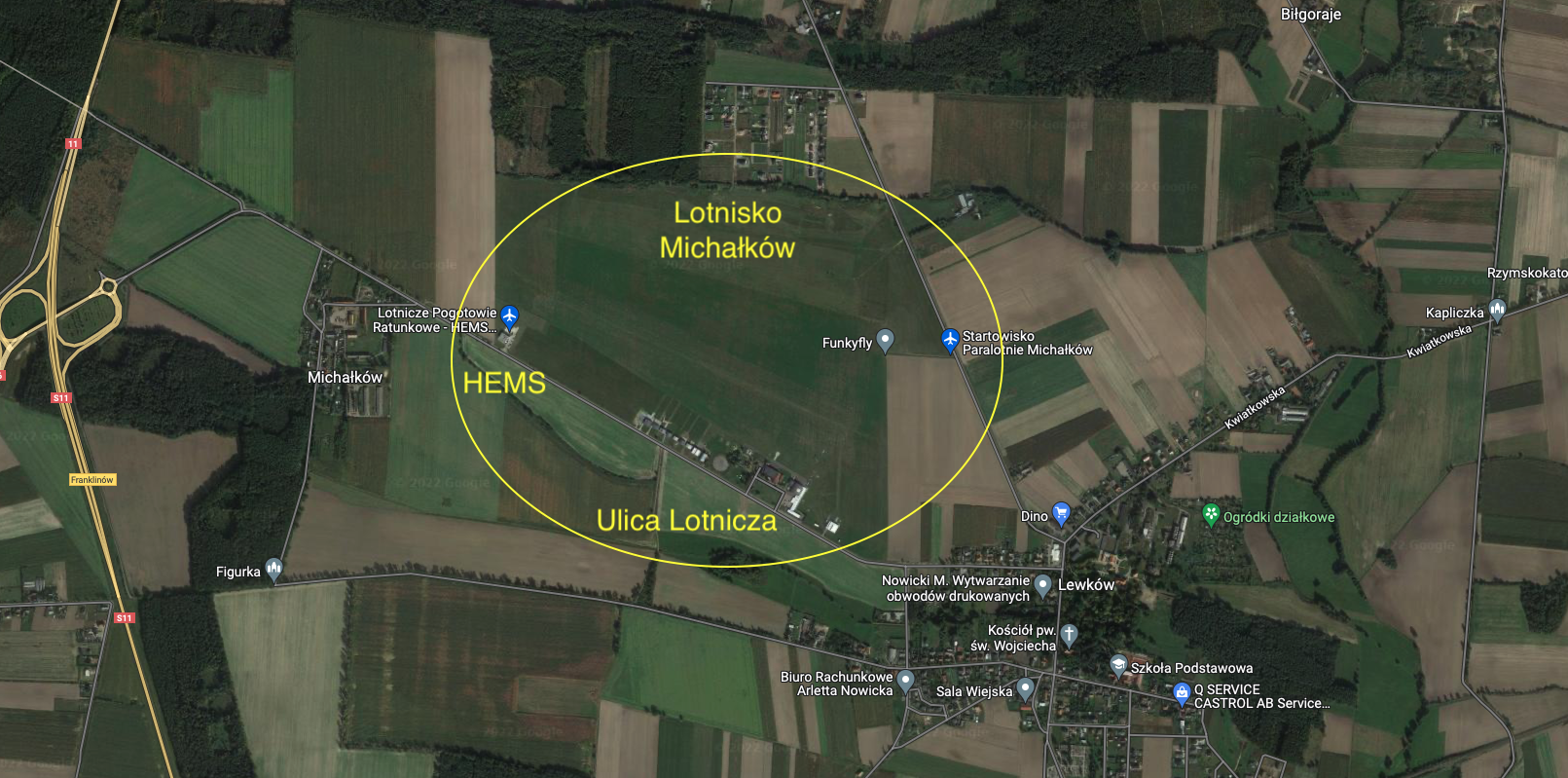
Ostrow Wielkopolski Airport - Michalkow.
Geographic coordinates: 51.701N 18.847E. Elevation 143 m above sea level.
Ostrów Wielkopolski - Michałków airport is a sports airport. It is located 8 km north of the city center. The airport is managed by Aeroklub Ostrowski. The HEMS air ambulance base is located at the airport. The airport was opened in 1954 as another airport of the Aeroclub of the People's Republic of Poland. The airport received the ICAO code EPOM. In 1969, the airport was entered into the register of airports of the Civil Aviation Office, under item No. 6. The airport has a ground take-off field with two or three RWYs. Air operations are carried out only with the consent of the airport manager. At the airport there are hangars, a complex of airport service buildings and a complex of Aeroclub buildings. The following sections operate in the Aeroclub: airplane, glider, parachute and motor hang glider. There is a club and a cafe. The airport is sometimes used by firefighting aircraft. Every year, in July, the Ostrów Mayor's Cup competition in gliding is organized. Since 2011, an air festival has been held at the airport every year.
The main RWY measures 961 m x 49 m and lies in the direction 114/294. RWY is rolled and systematically mowed and is marked with daily signs. Edge lights can be put on at night. Radio: Michałków - Radio 122.2 MHz.
Near the Michałków airport there is a railway line Ostrów Wielkopolski - Kalisz and the Czekanów railway station.
There are four other landing sites near Michałków Airport:
Stoneware to the north. Geographical coordinates: N51°49'40.6" E17°41'10.9". Ground RWY with dimensions of 470 m x 10 m. The airstrip is private. It is necessary to contact the owner by phone before arrival.
Szklarka Przygodzice towards the south. Geographical coordinates: N51°29'17.4" E17°47'42.2". Elevation: 438 ft = 134 m. Ground RWY with dimensions of 406 m x 15 m. Direction 122 / 302. The airstrip is private. It is necessary to contact the owner by phone before arrival .
Siedlików to the south. Geographic coordinates: N51°28'40.5" E17°56'38.9". Elevation: 575 ft = 175 m. Landing direction: 019 / 199. RWY dimensions: 685 m x 55 m. The airstrip is private. Prior to arrival it is necessary to contact the owner by phone .Watch out for the power line that crosses the RWY.
Majors to the south. Another name for Przytocznica. Geographical coordinates: N51°25'54.1" E18°03'30.4". Elevation: 550 ft = 168 m. Ground RWY with dimensions of 405 m x 40 m. The airstrip is private. It is necessary to contact the owner by phone before arrival.
Medical Air Rescue HEMS Ostrow Wielkopolski - Michałków.
On November 18, 2016, the official inauguration of the duty of the Helicopter Rescue Service crew in Ostrów Wielkopolski with the seat of the LPR branch at the Michałków airport took place. The creation of this base was possible thanks to the purchase of new EC-135 helicopters for the Polish Medical Air Rescue in 2015. The base operates during the day. Call sign - Rescuer 21. The base is a container type, but there are plans to build permanent facilities. The base is operated by a full medical and technical staff. The new base will be financed by the Marshal of the Wielkopolska Region.
Written by Karol Placha Hetman