Katowice 2010-11-04
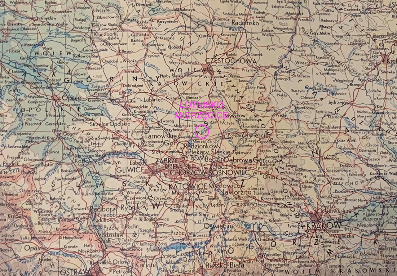
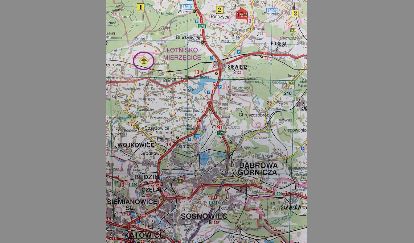
Mierzęcice Pyrzowice Airport.
Geographic coordinates: 50.471E 19.074E. Elevation 298 m.
A few words about the name of the airport.
The airport was built during the German occupation. In 1945, it was occupied by Muscovites. In 1948, the Soviet army placed the airport under the administration of the Polish Army. From that moment on, the name Mierzęcice Airport came into use, after the town located nearby, which currently has the status of a commune. This name operated until 2000, when the airport was taken over by a civil partnership. At that time, the name Pyrzowice Airport came into use. This name was taken from the small town located closest to the airport. The name change was intended to help promote the airport, to give potential passengers the impression that a completely new airport had just been established in the air connection system. Physically, the airport already existed. But since 2000, it began to function as a civilian airport providing commercial services.
A bit of history of the region.
From the beginning of Polish statehood, the lands where the Mierzęcice Pyrzowice Airport is located belonged to Poland. After the division of the districts and the subsequent unification of Poland by Władysław Łokietek, this area found itself on the border between Silesia and the Republic of Poland. Under Casimir the Great, they became part of the Kingdom of Poland. This was the case until the Swedish invasion of the Republic of Poland in 1655. Then the Vasa dynasty took possession of Opole, including Głogówek, and up to Częstochowa. After the second partition of Poland, this area came under the rule of the Prussians. After the third partition of Poland, this area finally came under the control of the Russian partition. During the times of the Duchy of Warsaw and the Kingdom of Poland, this area was located on the border of the Kingdom of Prussia.
After 1918, the area we are interested in became part of the Reborn Republic of Poland. The Polish authorities retained the administrative division in the areas of the former Russian partition. The administrative reform of the Republic of Poland was carried out in 1927. On January 1, 1927, a new Zawiercie County was created. At that time, the Mierzęcice Commune was excluded from the Będzin County and incorporated into the Zawiercie County. After the German army attacked Poland in 1939, the area was incorporated into the paradise. Only in 1945, the area returned to Poland. In the period 1945-1975 the town belonged to the Silesian Voivodeship, then in the period 1975-1998 to the Katowice Voivodeship, and from 1999 to the Silesian Voivodeship.
In the area we are interested in, since 1955, there have been two communities with 20 towns each: Przeczyce: Przeczyce, Boguchwałowice, Boguchwałowice II, Toporowice, Mrowiniec, Skotnica, Stara Wieś, Podmłynie, Zarzecze, Pasieka Zakamień, Komorne, Dąbrowska, Gostów, Pałęczek, Gaj, Sławniów, Przymiarka, Pustkowo Górnicze, Biała. Mierzęcice: Sadowie I and II, Najdziszów, Nowa Wieś, Targoszyce, Zawada, Zendek, Strąków, Przy Szosie, Przy Głosu, Łubne, Niwiska, Zadzień, Godowa, Pasternik, Dąbrówka, Ostrowy, Mierzęcice - railway station, Niedźwiadek wilderness. On January 1, 1973, the Mierzęcice Commune was created from these two communities. It included 9 towns, which were concentrated in 8 villages. In 1975, counties were abolished. On January 1, 1999, the commune became part of the reactivated Będzin County.
The town of Mierzęcice.
Mierzęcice is located in the Silesian Voivodeship, in Będzin County. It is the seat of the commune. The town has agricultural, residential and recreational functions due to the Przeczyce water reservoir. The airport itself is located on the border of the Mierzęcice and Ożarowice communes, and at the same time on the border of Będzin and Tarnowskie Góry counties.
The Mierzęcice commune is located in the central part of the Silesian Upland, 25 km north of Katowice. According to data from 2002, the Mierzęcice Commune has an area of 51.27 square kilometers. Agricultural land covers 67% and forests 15%. The commune constitutes 13.93% of the district's area. In 2004, the commune was inhabited by 7,305 people, 3,748 women, 3,557 men, the population density was 142 people per square km. According to data from 2002, the average income per inhabitant was PLN 1,225.88.
Geography of the area. The area belongs to the Upper Silesian Upland with the highest elevation 397 m above sea level. The Czarna Przemsza River flows through the eastern part of the commune. There is also the Przeczycki Reservoir, with an area of 6 square kilometers. The northern part of the commune is covered with forests constituting the Forest Protection Belt of the Upper Silesian Industrial District. There are 2 junior high schools and 5 primary schools, two kindergartens and an Extracurricular Work Center in the commune. About 900 children study in the institutions.
National Road No. 78 runs through the town in the east-west direction, connecting Chmielnik with Chałupki, at the southern border of the Republic of Poland. From the National Road No. 1, from the south-east to the Airport, there is the S 1 Expressway, approximately 12 km long.
The history of Mierzęcice airport.
After the attack of the Germanic army on the Republic of Poland, the area of Mierzęcice was incorporated directly into the paradise. In accordance with Germanic ideology, the military system began to be expanded in the former western areas of the Polish-Lithuanian Commonwealth. The area we are interested in was intended to establish a military training ground, the main facility of which was to be an airport.
In accordance with the decision of the German authorities, the construction of the airport began in 1940. A swampy area between the towns was chosen; Mierzęcice, Pyrzowice (Ożarowice) and Zendek. The occupiers did not have a big problem with the displacement of the population, because it was the extermination of the indigenous population, i.e. Silesians and Poles. The occupier used a significant percentage of this population for forced labor.
The military complex was called Zendek. The airport itself was originally named Tarnowitz. But since 1937, there was an airport with the same name in the area of Rajch. Therefore, to avoid any mistakes, the nave was changed.
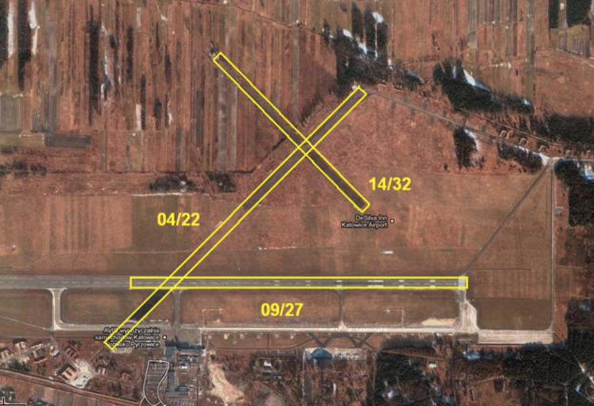
First, melioration works began. Kilometers of drainage ditches were dug and hundreds of meters of drainage were installed. The water was drained into ponds with planted wicker and calamus. The overgrowing ponds were to be used in the future to obtain peat as an energy material. Soil and rubble from demolished houses were brought to the planned RWY sites. The area has been leveled.
The flight field was designed in line with the trends of the time. Three RWYs were marked out on a triangular plan. In the direction 14/32 RWY, with a length of 1,000 m, RWY in the direction 04/22, with a length of 1,500 m, and RWY in the direction 09/27, with a length of 1,500 m. All RWYs were 50 meters wide and had a bitumen- concrete or asphalt-basalt. This configuration was to ensure safe landing, regardless of the direction of the wind.
From the beginning, the airport served as a staging ground for air units traveling to and from the Eastern Front and its supplies. Glider training for future pilots of the "invincible Aryan army" was also conducted here. In 1942, the airport was named Udetfeld in honor of the German flying ace of the Great World War, General Ernst Udet, who committed suicide in 1941 to protest against Hitler's policies.
At the end of World War II, thanks to a German aircraft designer, tests of Messerschmitt 163 Komet rocket-powered jet aircraft began at the airport. A pilot school was also established, which contributed to the creation of two air squadrons equipped with Me 163 Komet aircraft.
The failure of the war meant that the Germans left the airport without a fight in January 1945 (probably 1945-01-19), partially destroying it. Explosive charges were placed at regular intervals on the runways. The detonation of the charges created deep holes in the road surface. The Muscovites quickly filled the craters and exploited the airport. The predominance of westerly winds resulted in the Muscovites being completely renovated, only RWY in the direction 09/27, and the other two RWYs were not renovated or used. The Muscovites occupied the airport until 1948, when the subordination of airports in Poland was somewhat corrected. The crux of the matter was that the CCCP army was unable to maintain the airports it had taken over in Poland (and there were about 20 of them) and other "allied" countries. Some airports managed by the Polish Army fell into Soviet hands, and the Soviets gave others to the Polish Army. This is how the airport came into Polish hands and then received the (confidential) name of Mierzęcice.
Written by Karol Placha Hetman