Oleszyce 2023-02-03
Oleszyce airport near Lubaczów.
Geographic coordinates: 50.171N 23.057E.
History the Oleszyce.
The area of Oleszyc until the end of the 10th century was a Polish-Ruthenian borderland. Oleszyce, as a village, has been mentioned since the 15th century. The location acts with the preserved spatial arrangement have been preserved. In the 16th century, there was already a typical old town square with a town hall. Around the market square there were loose buildings, mostly wooden houses.
The town hall was built in the second half of the 17th century and owes its present appearance to the reconstruction carried out in the 18th century. The town hall is a four-sided building with an inner courtyard. The front side, on the south side, is two-storey. The other wings are single-storey. Each side is covered with a classic gable roof.
Until the 16th century, Oleszyce belonged to the Duchy of Przemyśl and was a noble town. From the 17th century, the town belonged to the Belz Voivodeship. Originally, Oleszyce was called Hieronimów, in honor of the founder, Hieronim Sieniawski. The city belonged to well-known noble and magnate families, including the Sieniawski family of the "Leciwa" coat of arms, the Ramsz family, the Czartoryski family, the Potocki family and the Sapieha family. From the mid-15th century, Oleszyce was owned by the Ramsz family. In 1498, Oleszyce suffered during the Tatar invasion. The village was destroyed, most of the houses and the wooden church burned down.
In 1576, a document elevating the village to the rank of a town was issued. The incorporation document sent by Hieronim Sieniawski was confirmed on February 26, 1578, in Warsaw by King Stefan Batory. The city was granted the right to hold two fairs a year; for Pentecost and St. Łucja, and weekly markets every Friday. In addition, residents were exempted from scrub and market taxes for 12 years. The city took on an urban character - a market square, a town hall, streets surrounded by earth embankments and wooden fortifications. Three nationalities lived here; Polish, Russian, Jewish. The inhabitants lived from agriculture, small crafts and partly from trade. Craftsmen were here: blacksmiths, carpenters, coopers, shoemakers, furriers. In the 17th century, a mill, a brewery, a distillery and an inn were opened.
In 1725, the Sieniawski family began building a new palace. In 1744, August Czartoryski received a privilege from King August III of Saxony that allowed him to introduce additional markets on Thursday and Sunday. In 1799, there were 340 houses in Oleszyce, including 28 brick houses. The population was 1,745, including 1,197 Christians and 547 Jews. In the first half of the 19th century, the town passed from the hands of the Czartoryski family to the Zamojski family. In the second half of the 19th century, Oleszyce had 2,286 inhabitants.
Oleszyce was not spared by fires, plagues and crop failures. Fires were mainly caused by lightning (thunder). As a result of the first partition of Poland, Oleszyce became part of the Austrian monarchy. In terms of administration, they belonged to the Żółkiew district, and from 1867 to the poviat starosty in Cieszanów. The youth of Oleszyce and the surrounding area took part in the January Uprising of 1863. A field hospital for wounded insurgents was set up in the city.
In 1901, the town was destroyed by a great fire, which contributed to its collapse and, as a result, to the loss of city rights in 1915. After the rebirth of the Republic of Poland in 1918, Oleszyce became part of the Lubaczów county.
On September 8, 1939, 18 German bombers made a bombing raid on Oleszyce. On September 12, 1939, the German army occupied Oleszyce without a fight. On September 15-17, 1939, there was a battle near Oleszyce between German troops and the 21st Mountain Infantry Division, commanded by General Józef Kustroń. On September 17, 1939, the general was killed in combat. Oleszyce was under German occupation. But as a result of agreements between the brothers; Muscovites and Germans, Oleszyce found itself under the rule of the Soviets. On June 21, 1941, German troops entered Oleszyce again. A new Germanic occupation began. On July 22, 1944, the Soviet army approached Oleszyce, and German planes bombed the town. 38 houses burned down, there were killed and wounded. Oleszyce was occupied by the Muscovites in the morning of July 24, 1944. The communist occupation of Poland began.
In June 1941, the palace of Prince Józef Sapieha was burnt down. The palace has not been rebuilt. Currently (2023) only the foundations remain of the palace.
The city of Oleszyce.
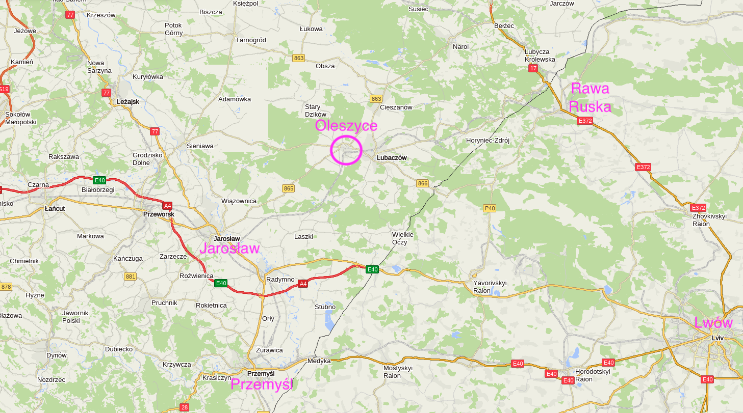
On January 1, 1989, Oleszyce was granted city rights again. The area of the city is 5.08 km2. In 2014, the population was 3,236 people, in 2017 it was 2,951 people, and in 2018, Oleszyce had 3,041 inhabitants. The city belongs to the Lubaczów poviat, which is only 8 km away. The distance from Oleszyce to Rawa Ruska is 54 km. Jaroslaw is 33 km. Think it 55 km. Rzeszów is 88 km. Zamosc is 81 km. Krakow is 246 km. Warsaw is 310 km.
The River Przerwa flows through the city. The football and volleyball team "Czarni Oleszyce" operates in Oleszyce. Oleszyce is located far from important communication routes. The following provincial roads lead to the city: No. 865, 867. Although the city is small, it has a road bypass.
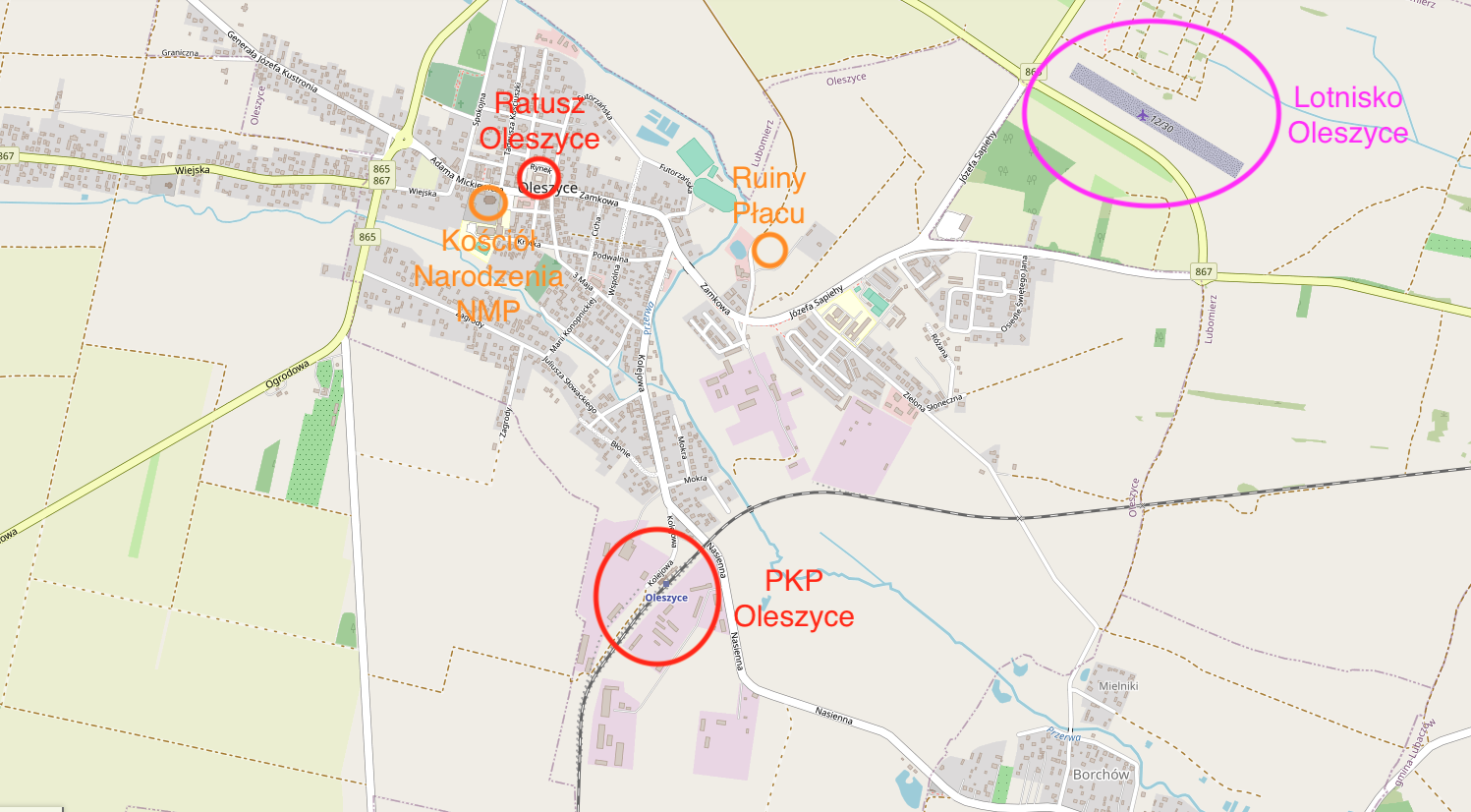
The monuments of Oleszyce include the remains of the foundations of the Sieniawski Palace with a park and embankments. The palace was completely destroyed in a fire on the first day of the German-Soviet War in 1941. A monument is the four-sided town hall, built in the second half of the 17th century. In Oleszyce there is also a parish church of the Nativity of the Blessed Virgin Mary from the 16th century. There is also a brick Greek Catholic church dedicated to St. Onofrego from 1809, which has not been used since 1947. There are thirteen shelters of the so-called "Molotov Line" in the vicinity of the city.
An important building in Oleszyce is the agricultural school. The school was established in 1972 and functioned until January 1, 1976 as the Agricultural Technical School. Then it was known as the Agricultural School Complex. Since 1989, the school has been under the Lubaczów District. From September 1, 2002, the school was called the School Complex. In 2009, a comprehensive high school was established. From 2021, the governing body of the school is the Minister of Agriculture and Rural Development. The school runs a boarding house, which makes learning easier for young people from further regions of the Podkarpackie Voivodeship. The school offers full-time, extramural and post-secondary education in agricultural fields. The school is constantly adapting to the needs of changing agriculture and related fields.
Oleszyce airport.
Geographic coordinates: 50.170N 23.057E. Elevation 768 ft.
It is not known exactly when the first plane landed at the later Oleszyce airstrip. It was probably related to attempts to protect crops in the fields. It could have been the PZL M-18 Dromader aircraft. For many years, nothing happened at this landing site. But the Oleszyce Forest District proposed creating a permanent airfield for firefighting planes. On August 18, 2016, the airport was entered into the records of the Civil Aviation Office as a landing site for the Oleszyce Forestry Inspectorate. Registration number ULC 360. The manager of the airport is the Oleszyce Forest Inspectorate. The helipad was reactivated with a view to fire protection of forest areas and intended for patrol and firefighting flights. The helipad is suitable for helicopter service. The hospital in Lubaczów is 5 minutes away from the landing site.
The airstrip is located about 1.5 km from the town hall in Oleszyce, in the north-east direction. This location is also favorable for Lubaczów. It is located at the intersection (roundabout) of provincial roads No. 865, 867.
The landing site received RWY with a ground surface - grass. Dimensions 620 m x 30 m. RWY is located in the direction of 122/302 and is marked out with white signs. The airport can accept aircraft with a maximum take-off weight of 5,700 kg. There is parking at the airport.
Oleszyce railway station.
Geographic coordinates: 50.157N 23.037E.
The construction of the railway line in 1884 contributed to the development of Oleszyc, although petitions had already been sent to the tsar to consent to the construction of the railway route. The trail was supposed to connect Jarosław - Rawa Ruska. If not for the influence of the owners of Oleszyce, the line would run from Nowa Grobla directly to Lubaczów, bypassing the town of Oleszyce at a distance of about 5 km. The station was built to the south of the city center (town hall), approximately 1,200 m away. The railway station is located within the city limits.
The first passenger and freight train arrived in Oleszyce on July 6, 1884. The line connected Jarosław - Oleszyce - Lubaczów - Rawa Ruska. From July 6, 1884, the station was named Oleszyce. During the defensive war of 1939, when the Muscovites occupied this area, the name of the station was written in Cyrillic. The Polish spelling returned on October 25, 1945.
At the station, a station, a residential building, a signal box and a loading yard were built. There was a ticket office and a waiting room in the station building. The station is very modestly furnished. The station had one main track, two side tracks and a siding. All switches were manual. Initially, there were no shape semaphores, and traffic was carried out on the basis of a timetable and reports sent by telegraph, and then by telephone. Light semaphores were installed after World War II, but they are no longer there. There was no coal depot at the station, but the locomotives could replenish water. There was no roof on the platform and no tunnel under the tracks. A paved road leads to the station, which was named Kolejowa Street. Several workplaces were built near the station. Among other things, there was a sawmill.
After the Second World War, the line lost its economic importance due to the change of the state border. At that time, Rawa Ruska found itself in the CCCP area. The route was mainly used by echelons and strategic goods. With the construction of the Werchrata - Hrebenne link, passenger traffic returned, and long-distance traffic at that. The trains Kraków - Rzeszów - Zamość - Hrubieszów used to run this way. After the construction of the Stalowa Wola - Zwierzyniec trail, the trail as a passenger route lost its importance. In 1998, the Oleszyce station was downgraded to a passenger stop. Until 2015, passenger traffic was intermittent.
Currently (2023) it is the railway line No. 101 Munina - Hrebenne, which is 82.789 km long. There are stations and stops on the trail: Dunina - Surochów - Bobrówka - Zagrody - Korzenica - Nowa Grobla - Oleszyce - Lubaczów - Basznia Dolna - Basznia - Basznia Polska Siarka - Horyniec Zdrój - Dziewięcierz - Werchrata - Siedliska Tomaszowskie - Hrebenne. The rope is single-track, non-electrified.
Currently (February 2023) 6 trains leave the Oleszyce station daily. There are trains to the following stations: Horyniec-Zdrój, Jarosław, Lubaczów, Rzeszów Główny. All connections are made by the PolRegio carrier.
Written by Karol Placha Hetman