Witnica 2022-02-22
Witnica landing field and the surrounding area.
This article describes the landing sites near the city of Kostrzyn nad Odrą.
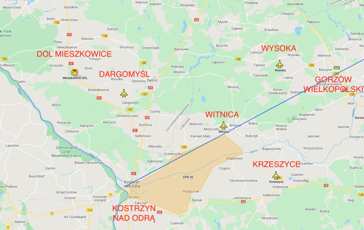
The area between the city of Gorzów Wielkopolski and the city of Kostrzyn nad Odrą is one of the most interesting in Greater Poland. The distance between the town of Gorzów Wielkopolski and the town of Kostrzyn nad Odrą is 45 km. The area administratively belongs to the Lubuskie Voivodeship. This is where the Warta Mouth National Park is located. There are hiking, biking and canoeing routes here. There are several lookout towers. In the city of Kostrzyn nad Odrą, the International Bicycle Trail "R-1" to Rusinowo begins, along the rivers: Warta and Noteć, 498 km long.
There are four airports (airstrips) in this area and additionally the Road section of Mieszkowice DOL. Many daredevils have been passionate about flying for a long time. In nearby Berlin, Otto Lilienthal flew a distance of 300 meters in the glider. Daredevil bought his experiences with a death in 1896.

In 1912, the inhabitants of Vietz (Witnica, now Tadeusza Kościuszki Street) could see the emergency landing of an aircraft belonging to the German-Russian flying club. The plane's engine broke down. The plane took off from Berlin's Johannistal airport with the intention of reaching St. Petersburg. In 1935, the airplane and glider sections were already operating in Witnica. The first glider was bought with contributions from members of the section and was named after the military pilot Herman Strunk, who came from Witnica, but who died during the Great World War.
B-17 Flying Fortress.
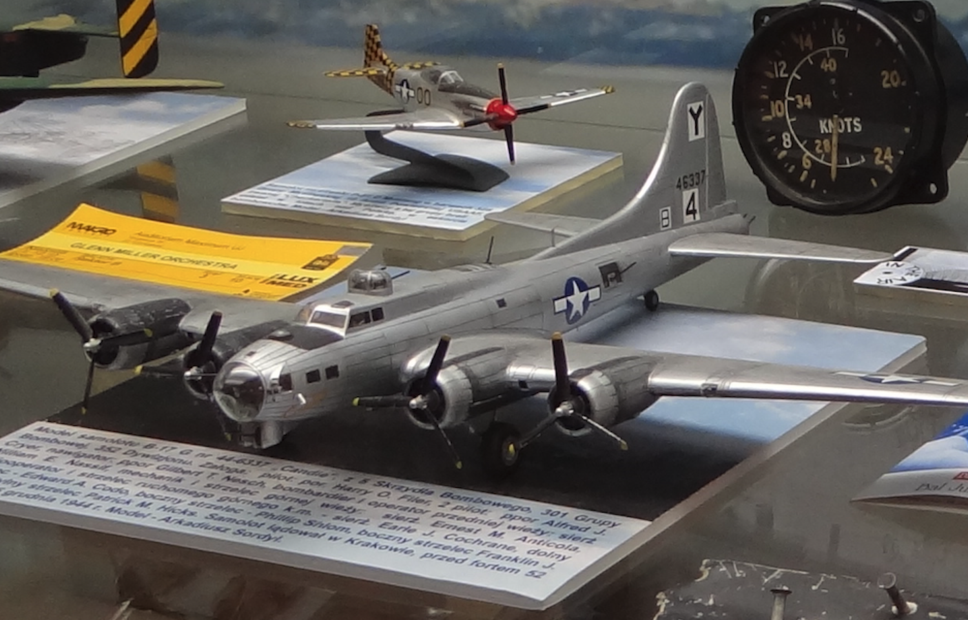
In February 1945, a B-17 USAF bomber, which had taken part in the bombing of Berlin, crashed in a forest near the village of Mosina. After the war, the pilots' graves and the remains of the plane were not found.
The town of Witnica.
The city of Witnica is located in the Lubuskie Province in the Gorzów County. The name Witnica comes from the words flagellum, witka, i.e. a kind of willow. The German name of the city is Vietz. The settlement was founded by the Knights Templar around 1100. The inhabitants were mainly engaged in fishing. These areas were for some time under the rule of the Piast dynasty. There were two Piast castellans in Lubusz and in Santok. The oldest written mention of the settlement Witnica comes from 1252. In 1261, Witnica passed from the hands of the Knights Templar to the rule of the Cistercian Order of Mironice and the Piasts lost their influence. In 1539, the area came under the rule of Brandenburg.
In the 16th century, the town became part of the Hohenzollern estate. From the 16th century, for 300 years, a paper mill operated on the Vytna River. In the 18th century, an ironworks, a brewery and a cloth factory were established. From the beginning of the 19th century, the route of the Royal Prussian Post, connecting two centers: Berlin and Królewiec, ran through Witnica.
In 1857, Witnica obtained a railway connection - the Prussian Eastern Railway "Ostbahn": Kostrzyn - Krzyż Wielkopolski. Since then, the "Ostbahn" (Eastern Railway) has been added to the name of the village: Vietz. Since then, the ironworks in Witnica produced components for steam engines and locomotives. At the end of the 19th century, Witnica had six brick factories, a tile factory, a brewery, and a furniture and starch factory. There were four sawmills, three water-electric mills and three windmills. Witnica received city rights in 1935.
In 1945, as a result of the Second World War, the city was granted to Poland. The indigenous people were displaced to Germany. In 1946, Witnica was inhabited by 2,600 people. In the post-war period, Witnica was a local industrial and service center.
In 2019, 6,731 people lived here. The town of Witnica is located 26 km from Gorzów Wielkopolski, by the provincial road No. 132 (the Gorzów Wielkopolski - Kostrzyn nad Odrą route). The railway line No. 203 Tczew - Kostrzyn runs through the city. The Witna River, which is a tributary of the Warta River, flows through the city. The city has mainly food, brewing, metal, leather and building materials industries. In Witnica there is the Park of Signposts and Milestones of Civilization and the Museum of the Glory of Polish Arms in Witnica.
Museum of the Glory of Polish Arms in Witnica.
The Museum of the Glory of the Polish Arms in Witnica is a private institution of Colonel Czesław Chmielewski (1924 - 2015). Mr. Czesław Chmielewski was born in Łuck. During World War II, he joined the 2nd Polish Army. In 1943, he was transferred to the officer school in Ryazan, where in 1944 he was promoted to a second lieutenant, and then he was transferred to the 17th Infantry Regiment, in which he commanded a platoon. He was wounded during the fights near Bautzen, and due to the lack of information about his fate, he was found missing and then dead. In fact, Czesław Chmielewski, while forcing the Nysa Łużycka River on April 29, 1945, was seriously injured while disarming a German tank. He was injured by 28 pieces of shrapnel. He was saved by Russian paramedics. He recovered for a long time in the hospital. He was transported by plane to Kiev. He stayed in the hospital in Kiev until June 20, 1945.
After rehabilitation in Otwock, he returned to the 5th Saxon Infantry Division and on July 20, 1945, took command of the watchtower in Cedynia. After handing over the border protection to WOP units, he still served in the 5th Infantry Division until demobilization in 1949. He left the army as a captain and went to Witnica, where he worked at the State Machine Center. From 1974, he was retired.
In the 70s, he read a book by Kazimierz Kaczmarek, from which he learned about his death and that he was posthumously awarded the Order of Virtuti Militari. Following the book's footsteps, he found his tombstone and those of his friends in the military cemetery in Zgorzelec. Then, as a tribute to his fallen colleagues, he decided to create a museum of military memorabilia. The first exhibit was the Order of Virtuti Militari awarded to him. The museum was established on October 17, 1972. Over the years, the facility has acquired many exhibits. The open-air exhibition consists of cannons, howitzers and anti-aircraft guns used by the Polish Army during the Second World War.
Museum address: Witnica, Sikorskiego 35.
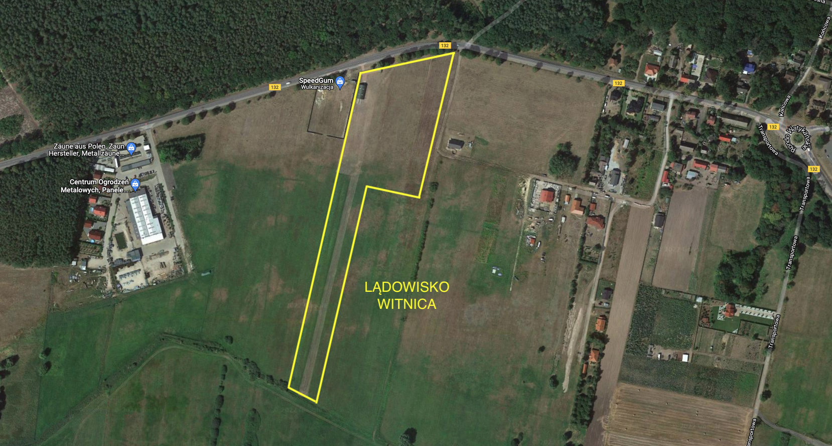
Witnica airport.
In February and March 1945, the Russians organized many field airfields in this area in preparation for an attack on Berlin. Several of these airports had take-off areas reinforced with metal meshes that the Russians had received from the Americans. Former airports in Krzeszyce and Pyrzany. At the Baranówko airport, on the Mosina - Dębno road, airmen from the 1st Polish Army were stationed.
At the end of the 70s, an airport for agricultural planes was organized in Witnica to spray forests against pests. Agricultural planes were withdrawn from Witnica in 1990. In the 90s, the airport was used by powered hangers. Since 1999, the company of Mr. Tadeusz Filip, a motor-hang glider lover, who produced engines and accessories for powered hang-gliders, operated at Myśliwska Street.
Witnica airport has the status of a landing site. Geographic coordinates N52 ° 40'23.6 "E14 ° 52'08.9" Elevation 63 ft. The landing field has one RWY in direction 013/193, dimensions 430 x 36 m. The runway is grassy. There is a small hangar at the threshold 19. Before threshold 01, at a distance of 360 m, there is an unmarked High Voltage electric line Contact: Mr. Tadeusz Filip, phone: +48 601 440 420.
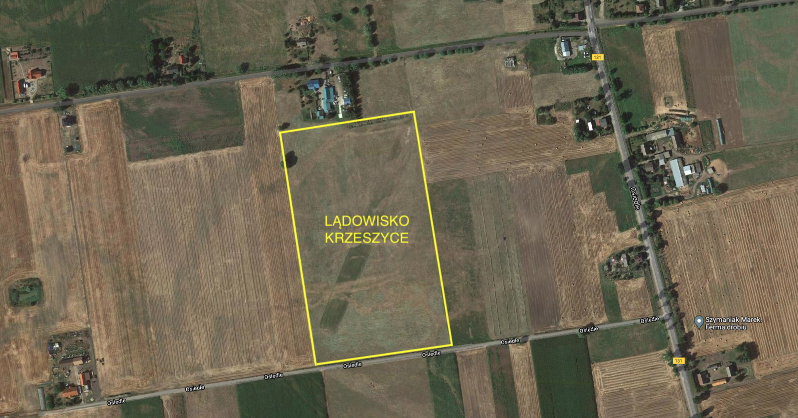
Krzeszyce airport.
The Krzeszyce airport was built by the Russians in March 1945, in preparation for the attack on Berlin. The airport is located on the plain of the left bank of the Warta River. Geographic coordinates N52 ° 35'59.1 "E14 ° 59'43.8" Elevation 30 ft. Currently, the airport has the status of a landing site. The landing field is rectangular, and the RWY is drawn diagonally. Direction 023/203. Dimensions RWY 320 x 25 m Radio 123.45 Contact: Roman tel. + 48 509444930. Unmarked grass strip, the owner's house west of the threshold 20, 400 m from the provincial road No. 131.
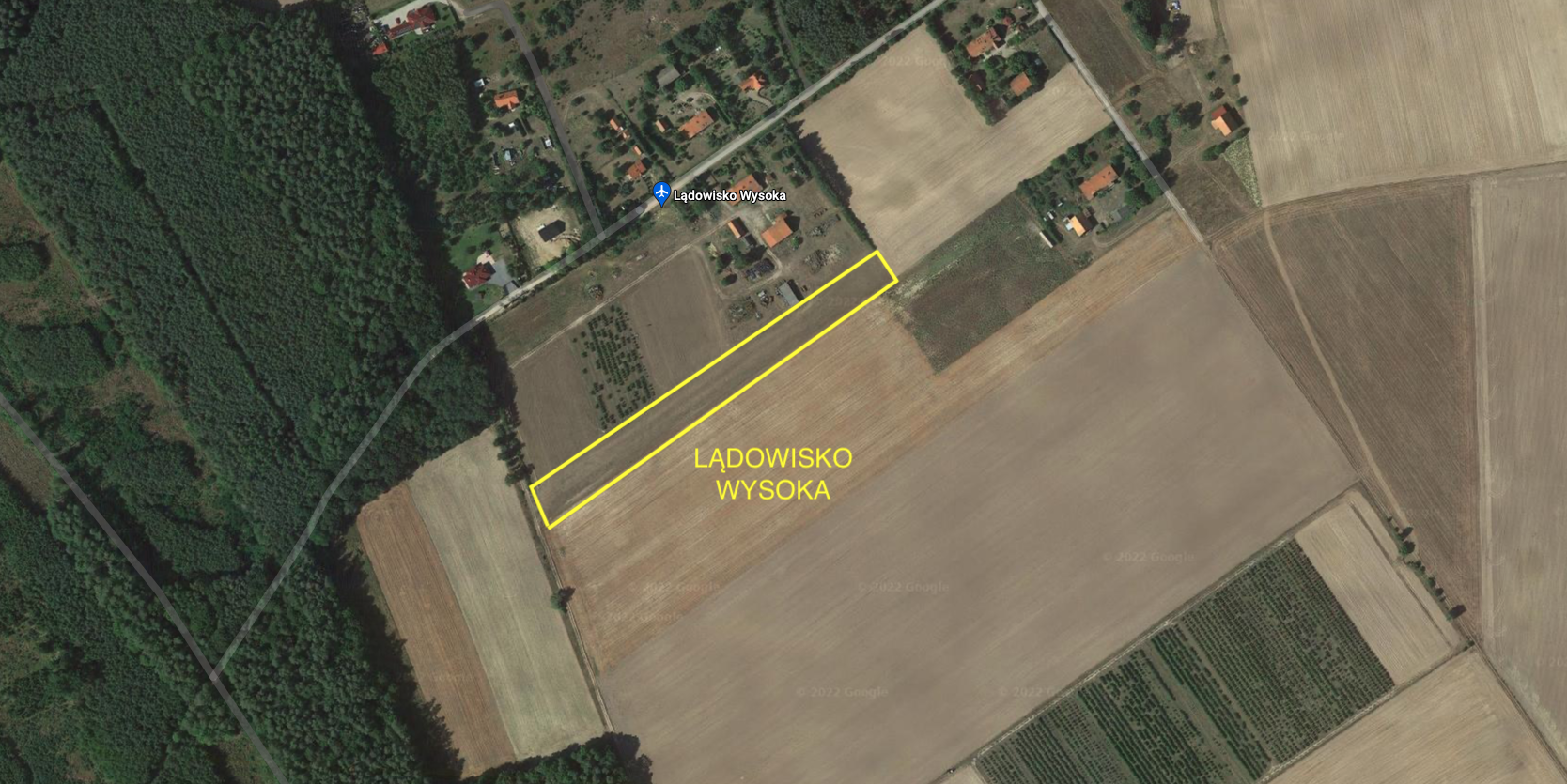
High airport.
High airport is located in the village of Wysoka Kolonia near the provincial road No. 130. More precisely, the hamlet of Czuchla. Geographical coordinates N52 ° 45'46.0 "E15 ° 00'15.8" Elevation 250 ft. RWY direction 055/235 Dimensions 320 x 20 m Radio 123.45 Contact: OSL Lotnik, Maciej Rudnicki tel: +48 696 581 932. Ground strip, grass Note: Three HV power lines, 520 m before threshold 23. Forest edge 160 m before threshold 05. Wind turbines at a distance of 1,500 m, east of the landing site. one hour before the scheduled arrival No fees Accessible from the provincial road No. 130.
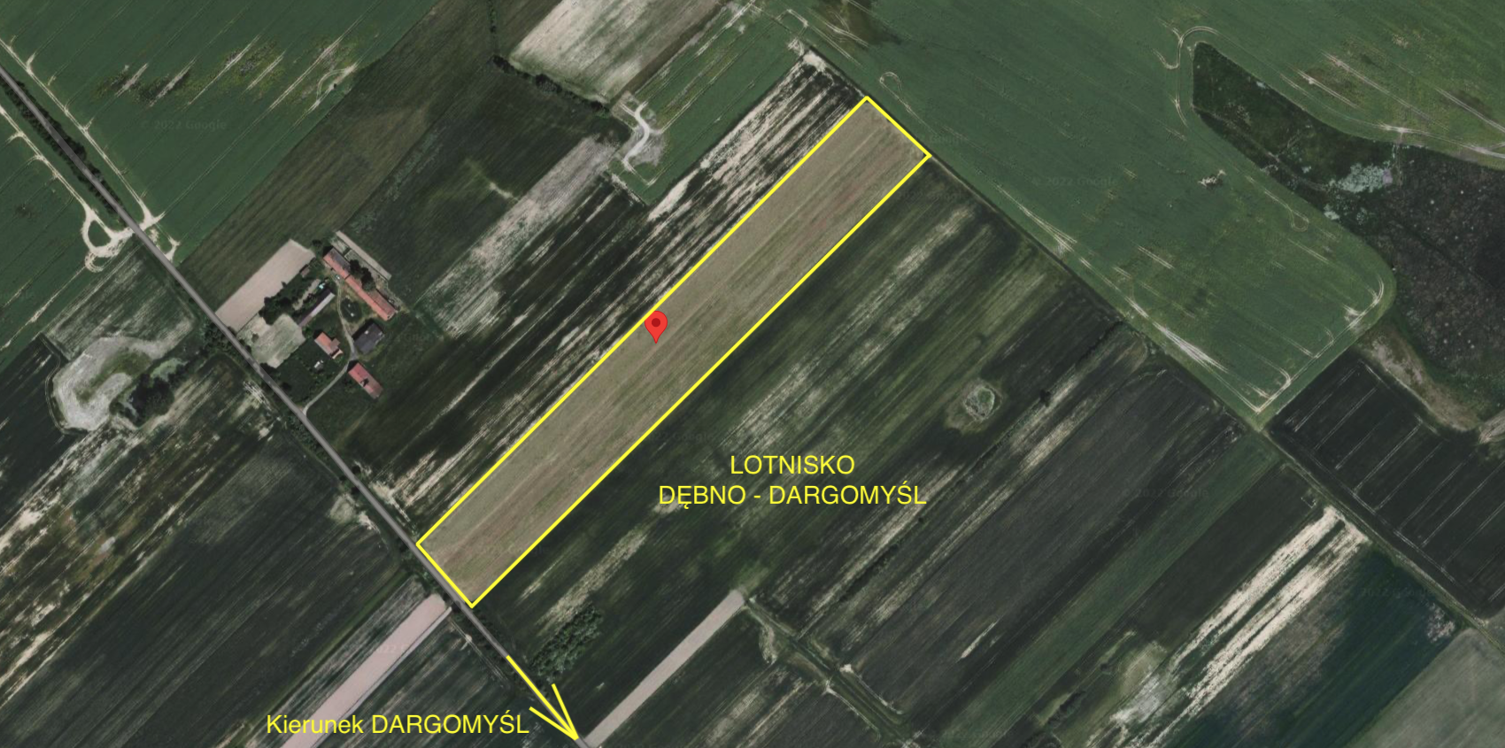
Dębno-Dargomyśl airport.
The Dębno-Dargomyśl airport has the status of an airstrip and is in private hands. It is located in the hamlet of Roztoki, north of Kostrzyn on the Oder. The village of Dargomyśl is located by the provincial road No. 127, and the landing site is located 2,000 m from the village of Dargomyśl in the north-west direction. It is 16 km from the airport to Kostrzyn nad Odrą, and 8 km to the town of Dębno. Coordinates of the airport N52 ° 43'12.3 "E14 ° 37'45.6". Elevation of 170 ft. RWY dirt, grass, direction 045/225. Dimensions 520 x 30 m. Contact with the owner - no details.
Road section of the airport Mieszkowice DOL.
The Road Section of the Airport Mieszkowice DOL is located on the provincial road No. 31, between the towns of Boleszkowice and Mieszkowice. Geographic coordinates N52 ° 45'02.7 "E14 ° 30'40.9". Direction 158/338. Dimensions 2,380 x 10 m. Asphalt surface. Elevation 150 ft.
DOL at DW No. 31 starts near the Boleszkowice railway station. The road is called Kościuszko Street. On the eastern side of the road there is the PPS (Aircraft Staging Plane). On the west side of the road there are former military and railway facilities. Currently (2022), only the double-track PGNiG siding is in operation for reloading fuel from railway cisterns to road cisterns. One building is occupied by the "Drift brothers areas" team. Most of the buildings are abandoned. Until 1953, a narrow-gauge railway from Troszyn was reaching Boleszkowice. The DOL section ends with PPS, which is also located on the eastern side of the road. DOL is on military records, but no exercises are being conducted here. Possible use of DOL requires cutting out a few self-seeding trees that grow close to the road. The width of the road is not sufficient for combat aircraft. There is one farm near the DOL.
Written by Karol Placha Hetman