Herby Nowe 2023-08-25
Coal train line, section Nowe Herby - Inowrocław. 1933.
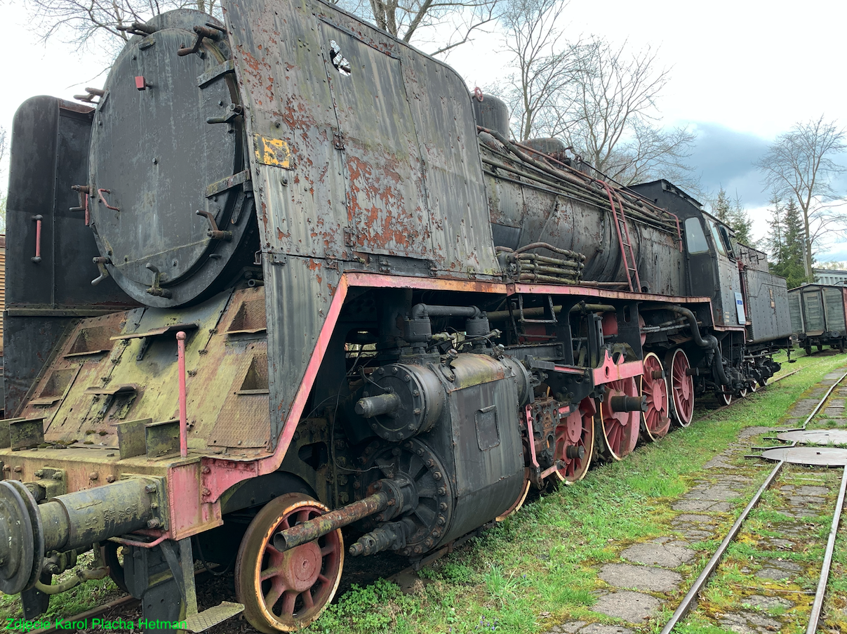
Photo description: Polish Ty37-17 steam locomotive was used to service heavy freight trains on Węglówka.
Silesia - Gdynia coal main.
The Śląsk - Gdynia Coal Railway is colloquially called Węglówka. The route is the shortest railway route from the mines of Zagłębie Dąbrowskie to the seaport of Gdynia. The route ensured the export of hard coal to other countries, mainly the Baltic Sea basin. It was the largest and most modern transport investment in the Second Polish Republic. The line was built thanks to the efforts of Poland and its then ally - France. It was built in the period 1926 - 1933.
Historical background.
In 1918, when Poland regained its independence, an important task was to combine the railway system into one efficient organism that would ensure the development of the country. At that time, an important transported commodity, apart from food, was hard coal, which Poland exported in large quantities. These exports provided significant revenue for the country's budget. The railway network inherited from the partitioning powers was inconsistent, unevenly developed and diversified in terms of technical equipment. There were different railway regulations on it. The routes taken over by the Germans and Austrians did not require large investments. It was worse with the rolling stock, which was handed over to us in a bad condition. The worst was with the routes taken over from Muscovites. They did not connect urban and industrial centers, only military facilities. In addition, a wide track was used. The exception was the Warsaw - Vienna line. There was little rolling stock, because the war was still going on in the Muscovite state.
Because the vital interests of Poland were different from those of the former partitioners, the existing railway lines changed their meaning. Many local lines gained economic importance for Poland. A new direction for the transport of goods has clearly formed; North South. The construction of Gdynia was forced by the attitude of the authorities of the Free City of Gdańsk, whose Germanic inhabitants took advantage of imprecise provisions in the Treaty of Versailles. This did not give hope for free use of the railway route in Gdańsk, although it was operated by PKP.
In 1925, a customs war broke out with the Germans, who closed their routes for the transport of hard coal. The coal industry and the Polish economy were threatened by a crisis. Until now, hard coal was transported by two railway routes that ran through Gdańsk.
The first road, 567 km long, "Korytarz Kluczborski": Katowice - Chorzów - Tarnowskie Góry - Kalety - Lubliniec - Kluczbork - Kępno - Ostrów Wielkopolski - Jarocin - Września - Gniezno - Inowrocław - Bydgoszcz - Tczew - Gdańsk. Transport along this route was still hindered by the Germans in their area and high transport fees. That is why a new Kalety - Kępno trail was built here, running entirely in Poland.
The second road, 666 km long: Katowice - Zawiercie - Częstochowa - Piotrków Trybunalski - Koluszki - Skierniewice - Łowicz - Kutno - Włocławek - Toruń - Bydgoszcz - Tczew - Gdańsk. Several new investments were made in the Łódź node, and above all, a new line Zgierz - Kutno was built, which increased the capacity of the route. There were 40 pairs of trains on the route during the day. Let us remember that river ports in Toruń, Bydgoszcz, Świecie and Tczew were also used for the export of hard coal.
However, these two railroads were not enough. Numerous hard coal trains blocked railway junctions, making it difficult to transport other goods, mainly food. Even before the construction of the Kalety - Podzamcze (Wieruszów) section, the development of the further part of the coal main was started. It was envisaged that Wieluń railway station would be a junction station for the further route towards Inowrocław. The first stage of the route was to run along the left bank of the Warta River. The first concession was issued in December 1924 to the Polish-French Association of Silesian-Warsaw-Baltic Railways. The route was 291 km long; Kalety – Wieluń – Opatówek – Inowrocław. However, due to lack of funds, the concession for the Association of Silesian-Warsaw-Baltic Railways was revoked.
New Project.
In this situation, a new project was developed. It consisted of two sections: the southern section Herby Nowe - Karsznice - Inowrocław and the northern section Bydgoszcz - Gdynia. The Inowrocław - Bydgoszcz section was already connected by a double-track line, 44 km long. This line was launched on May 26, 1872, and the second track was laid around 1899.
The problem was the Bydgoszcz node. There was a large railway junction in Bydgoszcz, but it was already overloaded. In order not to block the junction, a bypass on the eastern side of Bydgoszcz was proposed. The ring road was supposed to connect; Nowa Wieś Wielka - Kapuściska Małe - Maksymilianowo.
Another problem was the Kashubian section with difficult terrain and the proximity of the German border. This section is Kościerzyna - Gdynia with a length of 67 km. It was decided to use existing sections. The section Kościerzyna - Somonino, 25 km long, built in 1901, which was part of the Kościerzyna - Kartuzy line. The section Osowa - Gdynia, 16 km long, built in 1921 for the needs of the Polish Army, which belonged to the railway line Kokoszki - Osowa - Gdynia.
The southern section Herby Nowe - Karsznice - Inowrocław.
In 1925, the customs war began, which confirmed that Germans and Muscovites were enemies of Poland. In the event of a possible political conflict, they will not hesitate to attack the Republic by force. That is why a new coal route east of the Warta River was marked out. The first reason was strategic goals, i.e. moving the tracks away from the western border. The second reason was the economic aspect, i.e. the proximity of the railway tracks to Łódź; an important economic center.
On February 7, 1928, an ordinance of the President of the Republic of Poland was issued for the construction of the southern section of the trunk line; Herby Nowe - Inowrocław, 256 km long.
On November 8, 1930, the Minister of Communications, engineer Alfons Kühn, officially opened the Herby Nowe - Karsznice line, 99 km long. At the end of 1930, the northern part of the main line, 234 km long, was ready; Inowroclaw - Gdynia. The section Karsznice - Inowrocław, 156 km long, was not completed. The progress of the works was about 50%. Therefore, trains were dispatched by ring lines; The first one is Łódź - Kutno - Toruń - Bydgoszcz. The second is Kalisz - Ostrów Wielkopolski - Jarocin - Gniezno.
In 1928, the world economic crisis began and problems arose with the completion of the coal main line investment, financed by PKP. In this situation, talks began with France. The French capital of companies involved in the Polish market was used. Virtually from the moment of Poland's rebirth, France has been heavily involved in Poland's economic, military, social and political development. France did so with a view to having an ally from the eastern side of Germany. Negotiations between the Ministry of Communications and the Ministry of Treasury, and a group of French industrialists lasted as long as 9 months. The talks were difficult because there were economic problems in France as well.
The Franco-Polish Railway Society (Compagnie Franco-Polonaise de Chemins de Fer) was established. The agreement was signed on March 30, 1931. The seat of the comrade was in Paris. The shareholders were: Bank Gospodarstwa Krajowego on the Polish side, and Banque des Pays du Nord and the metallurgical and armaments concern Schneider et Cie. on the French side. The task of the company was to complete the construction of the Śląsk - Gdynia coal main and its branch Siemkowice - Częstochowa, 55 km long. The agreement covered the sections Herby Nowe - Inowrocław and Nowa Wieś Wielka - Gdynia. As a result, 458 km. In addition, 13 slip roads were to be built at junction stations, 34 km long. The company completed the Karsznice - Inowrocław section, 156 km long. From January 1933, the company was to derive financial profits from the coal main. The right to operate was granted to the company for a period of 40 years, with the possibility of purchase by the Polish government after 20 years.
The contract stipulated that Polish materials would be used for construction, and only Polish citizens would be employed. The operational management over the main was held by the Ministry of Transport and PKP. The company complied with the regulations on the carriage of the Polish Post, the operation of the telegraph and the priority of transport of the Polish Army transports.
The share capital of the company was small and amounted to 15 million French francs, including 7 million francs contributed by Poland. A loan was taken from a French bank. In May 1931, the company received the first loan installment of 400 million francs. The next two installments of the loan did not materialize within the stipulated period. Nevertheless, the investment was completed so that rail traffic could be operated. The company did not have funds for the purchase of rolling stock, so it transferred the operation to PKP.
On March 1, 1933, the Karsznice - Inowrocław section was launched, with a length of 156 km. Normal traffic on the entire route was launched in 1937.
In 1933, the company received the second tranche of the loan. This made it possible to complete the Siemkowice-Częstochowa branch, 55 km long. Until 1939, the company performed road works. Railway workshops were built in Karsznice and Kapuściska Małe near Bydgoszcz.
As expected, the trail brought significant financial profits. In 1937, 60% of the goods transported were hard coal, 20% other goods, including food and construction materials, and another 20% were imported goods. As a result of an annex to the agreement, the company was to use the line until 1975. But the German-Muscovite aggression against Poland and, as a result, the Second World War made the agreement invalid.
Carbon train T-T data:
The distance between Katowice and Gdynia is 552 km. Newly built sections with a length of 458 km. Lines that already exist; Katowice - New Herbs. Nowa Wieś Wielka - Inowroclaw. Kościerzyna - Somonino, 25 km long, built in 1901, which was part of the Kościerzyna - Kartuzy line. The section Osowa - Gdynia, 16 km long, built in 1921 for the needs of the Polish Army, which belonged to the railway line Kokoszki - Osowa - Gdynia.
The main line was planned as a double-track line. All engineering structures have been prepared for two tracks. But for the most part, the line is single-track, because the Second World War broke out, and after its end, the great of this world changed the borders. double-track sections; Siemkowice - Karsznice, Bydgoszcz East - Maksymilianowo and Osowa - Gdynia. It was 73 km in total. The Herby Nowe - Inowrocław line is double-tracked and electrified.
The main line was supposed to be technically uniform, with the exception of the Osowa-Gdynia section, where it was impossible to maintain proper slopes and curves. In order to prevent possible train derailments, mechanics were ordered to stop at Osowa and Wielki Kack stations in the direction of Gdynia. It was recommended to use a second locomotive.
All new railway stations were built with side tracks for 750 m long trains. Water towers were not built at many stations, but hydrophore pumps were commonly used. The fan-type locomotive shed was not built, only the stepped one, so as not to build expensive turntables. In addition, this type of shed did not limit the length of the used steam locomotive on the turntable. Technical facilities built; bridges and viaducts were an opportunity for young Polish engineers to prove themselves. Interval posts were used on the route, which allowed for greater rail traffic.
Rail-road crossings with main roads were made as standard. A lineman's house was being built at the crossing. The dams were made of steel pipes and equipped with wires called curtains. These wires prevented the passage of domestic animals (goats, sheep) under the dam (barrier). In addition, along the road, in front of the crossing, concrete barriers were installed, also to prevent the animals from stepping aside and onto the tracks. The barriers were lowered manually by the lineman, using a single crank and a system of steel cables. A bell rang mechanically as the barrier was lowered. Access roads were paved in order not to bring mud onto the tracks. The lineman had a telephone for communication and a timetable at his disposal. The passage was lit with oil lamps.
The main line bypassed many cities and industrial centers. It had its pluses and minuses. The upside was reviving some areas by building new industrial plants. The purchase of land for investment was cheaper and there was a labor force. An advantage was also not blocking communication in individual cities by building numerous rail and road crossings. The downside was limited access for travelers.
33 new stations were built along the entire route, according to the individual needs of a given region. Engineer Tatarczuch developed a new type of station, which was called "Bydgoszcz - Gdynia type". According to this design, 11 stations were built on the section mentioned. In 1928, engineer Kozak developed a different type of station, which was called "Type Herby - Inowrocław".
In the period 1965–1969, the entire coal main line from Tarnowskie Góry to Gdynia was electrified. The alternative section Maksymilianowo - Wierzchucin - Szlachta - Bąk - Kościerzyna - Osowa - Gdynia has not been electrified. Currently (2023), the pre-war route of the coal main line coincides with two railway lines: Line No. 131 Chorzów - Tczew (originally Chorzów - Nowa Wieś Wielka). Line No. 201 Nowa Wieś Wielka - Kościerzyna - Gdynia.
Line Herby Nowe - Inowroclaw.
The line starts at Herby Nowe station. To facilitate the exit and entry from the north, collision-free track lines were built. The exit is in an arc to the right (north-east), and the entrance is in an arc over the tracks to Wieluń, from the west. The two-track trail leads among the forests. The first was the Puszczew stop post, at 5 km of the trail. Currently (2023) it does not exist. The Wręczyca technical station is 10 km of the trail and is located among forests. From the west, the trail passes the village of Wręczyca Wielka, and at the same time crosses the Provincial Road No. 494 (Częstochowska Street) under the viaduct. The Grodzisko access checkpoint is 15 km of the trail. Currently (2023) the post does not exist.
The trail continues through the forests. At the height of Kłobuck, there is: a railroad crossing (Zakrzewska Street), then a bridge over the Biała Oksza River, then a railroad crossing (Slowackiego Street), then the trail passes the National Road No. 43 (Wieluńska Street) along the viaduct and there is the Kłobuck railway station. It is a 20 km trail. Behind the Kłobuck station there is a rail-road crossing (ul. Jana Długosza). Then there is a bridge over the Bród river. The trail enters the woods again.
Wet Częstochowa railway station, and currently a passenger stop, on the 26th km of the route. Currently (2023) the station does not exist, but there is an automatic block post. In the hamlet of Mrzygłód, the viaduct trail passes over a local road. Then, in the village of Miedźno, the route under the viaduct passes the Voivodship Road No. 491 (Częstochowska Street) and there is the Miedźno railway station. It is 32 km of trail. At the station there was a locomotive depot (demolished) and a water tower (closed). Behind the Miedźno station, the trail passes over a viaduct over a local road (Wypoczynkowa and Turystyczna Streets). Next is the bridge over the Liswarta River. The bridge is made of concrete, has four arches and a stone cladding. Metal barriers. The last renovation was carried out in 2022, together with the replacement of the track and traction network. Further, at the level of Popów village, there are two rail-road crossings (Pajęczyńska Street and Reymonta Street).
In the village of Dębie there is a viaduct over the tracks, used only by residents to access the forest. Here was the Dąbie station on the 36 km of the trail, and Annolesie on the 37 km of the trail. Both stations do not exist, but a passenger stop was created in Annolesie. There is a railroad crossing in Annolesie. The village of Więcki is a viaduct over the tracks with Długa Street and another rail-road crossing (Kolejowa Street). There is a standoff post, Więcki, at 40 km of the trail. The trail leaves the Śląskie Voivodeship and enters the Łódzkie Voivodeship.
At the height of Działoszyn there is a viaduct over a local street and a bridge over the Warta River. The bridge is called "The Railway Bridge at the Warta Cement Plant". The cementing is east of the tracks. The bridge is five-span, truss (the trusses are under the track surface), it is supported on four pillars and abutments. The pillars are concrete with stone cladding. The bridge is the largest investment on this section of Węglówka.
Next is the Działoszyn station with sidings to the cement plant. This is 54 km of the trail. Behind the station there is a railroad crossing of the National Road No. 42 (Wyzwolenie Street). Next was the Trębaczew access post (57 km), which no longer exists. Next is a new reinforced concrete railway bridge over the Struga River. Then there is a viaduct with tracks under the viaduct, along the forest road. Then a rail-road crossing and another along the Ożegowski Route. Then another viaduct over the tracks of the forest road. Then another railway viaduct over the forest road and another also over the forest road. The Sadowiec checkpoint is 60 km of the trail.
We reach the Chorzew-Siemkowice station, which was called Siemkowice during construction. This is 65 km of trail. Here comes the single-track line No. 146 Wyczep - Chorzew-Siemkowice, which connects the coal main with the Warsaw - Vienna route in Częstochowa. There is a railroad crossing in front of the Chorzew-Siemkowice station. Further on, the trail leads among agricultural areas and there are three rail-road crossings. There is a new viaduct over the tracks in the Gumnisko settlement. Previously, there was a railroad crossing. Then there are two more rail-road crossings for farmers. Then there is a viaduct over the tracks and another railroad crossing. In the village of Dąbrowa there is another rail-road crossing.
Then there is the Rusiec Łódzki railway station and a rail-road crossing along the National Road No. 74 ( Wieluńska Street and the next one along Dąbrowskiego Street. The Rusiec Łódzki station is 67 km of the route. Then there is a steel bridge over the Nieciecz River. Again, there is a forest section with three From the village of Dębina, the trail enters agricultural areas again, then there are five rail-road crossings and the Chociw Łaski station, the Chociw Łaski station is 77 km of the route, Behind the station there is a rail-road crossing along the Provincial Road No. 480 (Kolonia Zawady). There is a railway bridge over the Widawka River, made of steel, supported by two pillars and two abutments. The route, in a curve, bypasses the village of Rogóźno from the east. Then it runs through the former training ground. Then there are three rail and road crossings for farmers. In Wola Wężykowa there is viaduct over the tracks Siedlce Łaskie is currently a passenger stop, and it is 83 km of the route.
Then there is the Kozuby station and another two rail-road crossings. The Kozuby station is 88 km of the route. The Kustrzyce passenger stop is 93 km off the trail. Then there is the viaduct over Dolna Street in Sędziejowice. Provincial Road No. 481, the trail passes over the viaduct. After turning north-west, the trail passes the Grabia River. The bridge is a steel, two-span bridge supported by one pillar and abutments. Again, the trail heads north and passes a local road under the viaduct. At the height of the village of Marzenin, there is a railroad crossing along Wrzesińska Street. The trail bypasses the village on the west side. There is a footbridge over the tracks along Polna Street and the junction of Droga Krajowej S8 (DK12). The tracks run under three viaducts.
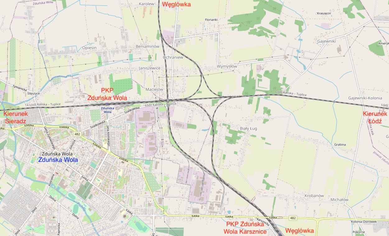
The trail is in Zduńska Wola - Karsznice. On the eastern side there is a locomotive depot - PKP Cargo Tabor Rolling Stock Repair Plant. A transshipment terminal is being built on the western side. Next is the Zduńska Wola Karsznice station and it is 99 km of the trail. The route under the viaduct passes Voivodeship Road No. 482 (Łaska Street). Then there is a large junction, because the Coal Main Line intersects with the Łódź Kaliska - Tuplice route. The city center of Zduńska Wola is to the west, as is the Zduńska Wola station. Węglówka passes over the tracks of the older trail. Movement in any direction is possible.
Further on, the trail crosses three railroad crossings and enters agricultural areas. There is a viaduct over the tracks in Suchoczasy. Then we have Lasy Szadkowice. There is a Szadek station near the village of Szadkowice. Next is the viaduct with the tracks underneath, along the Provincial Road No. 710. Then there is the viaduct over the local Kościelna Street. The trail crosses the Pichna Szadkowicka River and Grabowiny Street by a railroad crossing. At the height of Choszczewo there is a station level after the former passing loop. The trail passes four railroad crossings.
The trail reaches the Otok station, which is 122 km of the trail. Then, the trail crosses the Provincial Road No. 473 with a rail-road crossing. In the village of Pudłówek there is a viaduct with a local road over the tracks. There are agricultural areas here. Then there are six rail-road crossings. In the village of Bałdrzychów there is a viaduct over the tracks with a local road made of fieldstones. In Praga there is a railway viaduct over the National Road No. 72 and DW No. 703. It is near the village of Poddębice, which the trail passes on the western side. Next is a viaduct over the tracks with a local road. Again, the trail leads through the fields. There are six railroad crossings along the way. Then there is a viaduct over the tracks with a local road and another four rail-road crossings. There are stations between Zduńska Wola Karsznice and Kłudna: Dionizów 104 km (Posterunek), Szadek 110 km, Otok 122 km, Poddębice 126 km.
Then there is the Kłudna station (Kłódno; spelled differently) and 144 km of the trail. The station is very charming, but the square in front of the station and the access road are still unpaved. Behind the station, the trail crosses the Provincial Road No. 469 with a railroad crossing. The road is asphalted, the barriers are controlled automatically, the passage is monitored. The original concrete barriers along the road have been preserved. Further on, the trail runs through agricultural and forest areas. There is one railroad crossing. Then there is a viaduct over the tracks with a forest road, hardly used. Then there are four rail-road crossings of local roads. Then in the forest there is a concrete viaduct over the tracks. It seems that the viaduct has not been completed, because there are no abutments. The metal barriers have been cut off.
The trail passes the A2 motorway, which passes over the railway line via viaducts. Behind the motorway there is another rail-road crossing and the Kraski station, with a nice railway station. Kraski station is 152 km of the route. Then there is a concrete railway viaduct with a road under the tracks. The viaduct is low and vehicles with a height of 3.8 m are allowed. In the village of Polusin, the route crosses the historic Royal Route. There is a railroad crossing here. The trail enters swampy areas. Here is the Zbylczycki Canal and the "Dąbskie mud" ecological site. The Ner Canal is crossed by a bridge. We leave the Łódź Voivodeship and enter the Wielkopolskie Voivodeship.
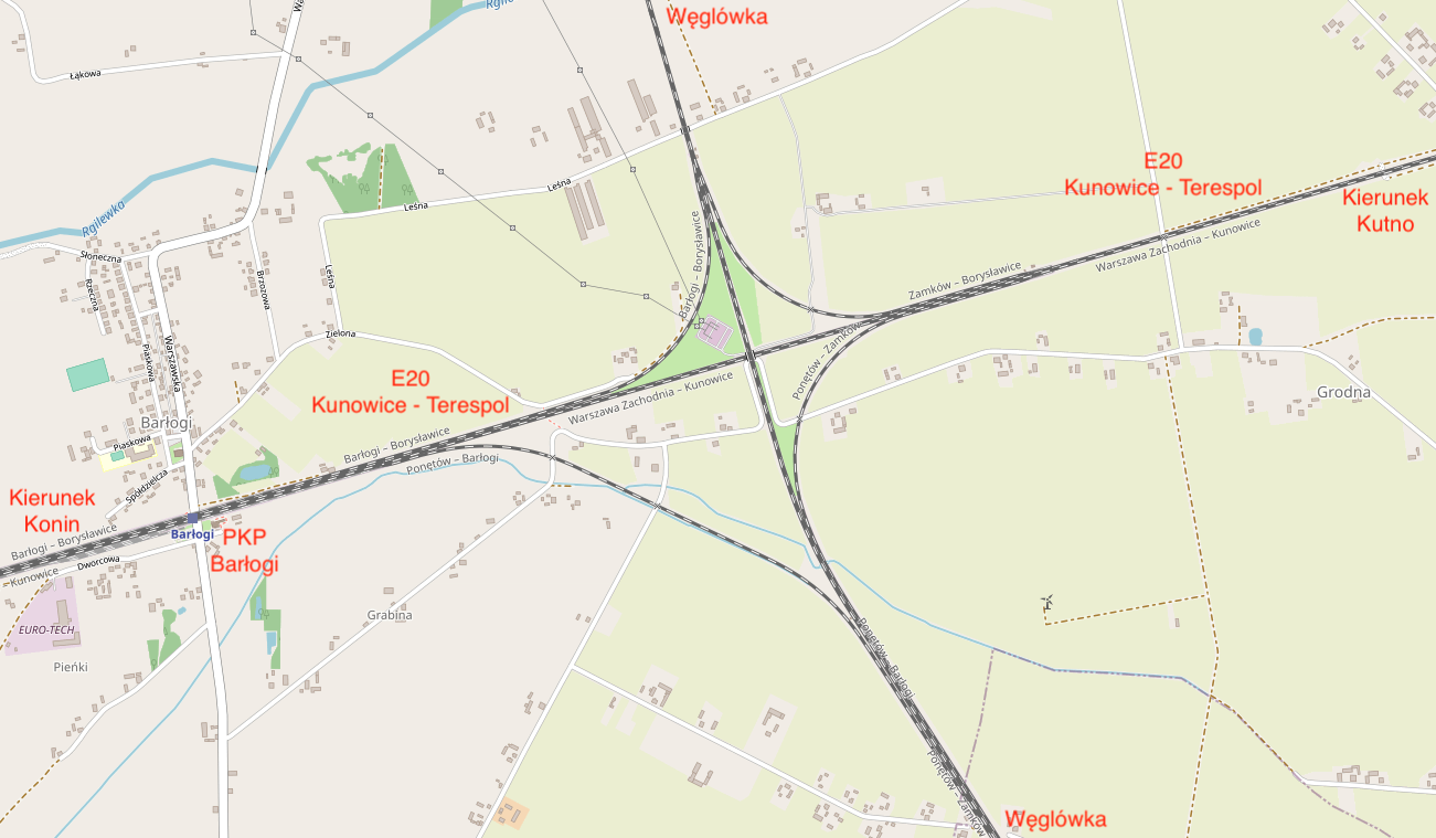
There is a Dąbie nad Ner station, which is 160 km of the trail. In front of the station there is a viaduct with a local road under the tracks. The train station is bigger than the previous two. The station is far from the village. At the rail-road crossing, the trail passes the Provincial Road No. 263. It passes the next rail-road crossing and in the forest there is an overpass over the tracks used as a path. The trail passes another railroad crossing. Then there is the bridge over the Orłówka River, the town of Wojciechów. The town of Adamin. There is a viaduct of the local road over the tracks that runs in the excavation. The trail passes another four railroad crossings. In front of the Ponętów station, there was an access post in Umień. The Ponętów Górny Pierwszy railway station is 171 km of the route. Behind the station there is an intersection of the Coal Main Line with the E20 Kunowice - Terespol line. At the intersection, traffic is possible in the direction of Warsaw, Poznań and further to Inowrocław. The Węglówka trail passes over the E20 line.
Further on, the trail passes the Regilewka River and then the National Road No. 92 (Emilewo Street). There are successively two rail-road crossings, a viaduct with a local road over the tracks and 5 more rail-road crossings. The Lipie Góry station is 182 km off the trail. The trail goes through the forests. The trail crosses the Provincial Road No. 270 and then the Provincial Road No. 263. The trail passes the town of Babiak on the eastern side. The Babiak station is 191 km off the trail.
Lake Lubotyń and the town of that name, the trail passes on the eastern side. Then there are four rail-road crossings. The route intersects with the Provincial Road No. 269 with a railroad crossing with automatic barriers. The trail passes the Noteć River. There was also a Lubotyń station on the 199 km of the trail, but it was liquidated. It was originally an access post.
The Zaryń station is 202 km of the trail. At the station there is a rail-road crossing with automatic dams and historic concrete road barriers. There is a Naftohurt company at the Zaryń station, which has its own railway siding. Then there are four more rail-road crossings. There is a viaduct over the tracks with a local road in the village of Zakret. Then there are another three rail-road crossings.
The Piotrków Kujawski station is 215 km of the route. Two railway sidings run from the station to nearby industrial plants. The city is on the west side of the tracks. The trail passes the Provincial Road No. 267 (Wrocławska Street), with a railroad crossing operated by a lineman. Then the trail goes over the Voivodship Road No. 266 (Mostowa Street). Then there is a bridge over the Goplop Śiecz Canal. The route passes the National Road No. 62 via a railroad crossing. From this point, the route turns more towards the west.
Chełmiec station, which is 225 km of the route. Then there are 10 rail-road crossings used by farmers. In the village of Bachorce there was a guard post. Karczyn station is 237 km of the trail. Then there are two viaducts over the tracks, and then there are five rail-road junctions. Then, the National Road No. 15, after its modernization into a dual carriageway, goes over the tracks. Here the trail turned even more to the north-west.
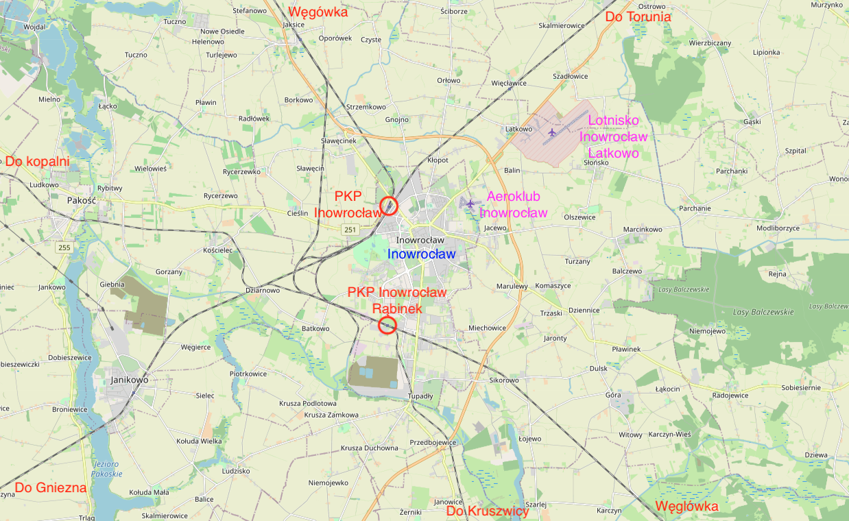
The Inowrocław Rąbinek station is 248 km of the route. Behind the station there is a large Inowrocław railway junction. The Inowrocław station was the end of this section of Węglówka and it was 256 km of the route from the Herby Nowe station.
Written by Karol Placha Hetman