Kraków 2018-08-10
How does the weather affect air travel?
Part 2.
Atmospheric temperature.
It is also worth paying attention to the temperatures in the altitude range from 0 m to 20,000 m, i.e. in the ranges of manned aircraft. In the troposphere, that is up to 10,000 m, the air temperature in general drops by an average of 0.6 degrees Celsius per 100 m with increasing altitude. However, this decrease depends on the air humidity. It is in humid air that it is 0.6 degrees Celsius per 100 m. However, in dry air this decrease is greater and may amount to 1 degree Celsius per 100 m. As a result, in the lower stratosphere the temperature may reach -60 degrees Celsius. But it is mostly at -54 to -55 degrees Celsius. Recall that in a typical home freezer, we have a temperature of -18 degrees Celsius. I remember how in the 1960s, pilots of IL-28 bombers, in summer, at an air temperature of +30 degrees Celsius, before boarding the plane, they put on very thick sheepskin coats because the planes did not have effective heating.
Oxygen.
One more thing we need to keep in mind is oxygen in the atmosphere. Although the percentage of air in the troposphere does not change significantly, its density (similarly to temperature and pressure) decreases with altitude. Thus, the oxygen component of air is less per unit volume the higher above the Earth's surface. And so, at an altitude of over 4,000 m, there is too little oxygen in the inhaled air for a human (without appropriate adaptive training) to survive there without a mask and an oxygen cylinder. Therefore, commercial aircraft have installations, air conditioning, ventilation and heating.
Flights in the clouds.
A few words about flying in the clouds. Gliders flew in the clouds almost from the beginning. As you know, cumulus clouds visible to the naked eye are part of a thermal chimney in which the air rises upwards. Therefore, flying in the clouds among sailplanes was treated as normal. There was even training in this area. However, it was eventually banned from flying in the clouds for three reasons. First, the humid air had a bad effect on the construction of wooden gliders. Second, there were gliders in collisions. Thirdly, the division of aviation has been introduced: into VFR ground visual flights and non-ground visual flights, into IFR instruments. It is also important to know that during the Battle of Britain, clouds often saved fighter pilots from oppression, although there were occasions that they came out of the cloud on their backs, even though they could be cut, that they were flying in the correct position. Cloud flight can be dangerous due to loss of orientation. The degree of confusion can be extremely high. So much so that the pilot no longer trusts the navigational instruments.
A few years ago, paragliders started to use the clouds because it gives them a "good carry". However, little is said about the fact that some of them lost their lives in this way. They probably got so carried that they were unable to break the heights. I have already mentioned what awaits a person above 4,000 m (lack of oxygen, negative temperatures, high humidity). Presumably, these people looked like ice mummies.
Wind.
Strong, gusty winds of up to 100 km / h usually prevent safe landing. The direction from which this world blows is also important. When specifying the wind speed, the average speed is always given. But a strong wind is never constant, neither in value nor in direction. Speed value varies by +/- 15%. If it is blowing 90 m / s behind it, it can actually be from 75 to 115 m / s. That is why the term gusty wind is used. While the horizontal wind is predictable, vertical movements are not so much. In a storm, they are wild movements.
Speaking of wind, remember that a typical commercial plane is flying at Ma = 0.80-0.85. If it encounters a strong headwind, this speed increases and on the wings and tail we can locally exceed the speed of sound, i.e. wave resistance, and this is associated with a possible loss of stability.
Saint Elmo's fires.
The harbinger of troubles in air transport may be the fires of Saint Elmo. St. Elmo's fires are also called St. Bartholomew, or the fires of Castor and Pollux. It is an acousto-optical phenomenon in the form of small electrostatic discharges on objects with sharp edges. These discharges are accompanied by hissing, whistling or whistling. This phenomenon always foreshadows a storm. It is easy to observe in the mountains and at sea, and in high-altitude flights. On ships, it is usually visible on masts. On airplanes, on the cockpit windscreen wipers. St. Elma can also cause volcanic ash, sharp particles of which rub against the edges of the aircraft's wings, creating a bright glow.
Storm.
The storm in the airport area is dangerous. Crews should always be sent back to an airport where there is no storm. In all such cases, the airplane is diverted to an alternate aerodrome that is scheduled in the flight plan for each flight. In cases where the conditions are transient (fog or storm), the weather is expected to improve in specially designated areas, and the fuel for this circumstance is also calculated in the flight plan.
The storm during the cruise is not dangerous, as the machine crews avoid them. For this purpose, they use weather radar, use hints from other crews of airplanes flying in these areas or air traffic controllers who also observe meteorological phenomena and are in constant contact with pilots. The problem begins when the crew wants to save fuel, for example, and instead of changing the route, they try to increase the ceiling and switch to a storm. They are counting on the plane to reach an altitude higher than the peak of the storm, which they basically do not know. Sometimes it works, but sometimes it doesn't. This was the case, for example, in the Moscow State. On August 22, 2006, the Tupolev Tu-154 (registration number: RA-85185), belonging to Pulkovo Aviation Enterprise, took off from the seaside resort of Anapa on the Black Sea for a flight to St. Petersburg. There were 160 passengers and 10 crew on board. The plane took an altitude of 10 700 m. After half an hour of travel, the pilots found a storm front. Due to the situation, the captain decided to change the course a bit and "jump over" the clouds. But in this case, the storm front turned out to be exceptionally high, with an altitude of 15,000 m. The plane fell like a brick. Nobody survived.
This brings us to the heart of the problem in high altitude flight safety, namely turbulence.
Turbulence.
The concept of turbulence occurs in the mechanics of continuous media, rheology and aerodynamics. In general, this term denotes the turbulent, complex, non-laminar, and even chaotic behavior of any physical system. We are most interested in the behavior of air masses in which the plane we are on board, i.e. aerodynamics and meteorology.
Even in the quietest center that our apartment may seem to us, there are such air movements that we can call turbulence. It is enough to observe the smoke from the cigarette. For about 5-10 cm, it rises laminar and calmly, but higher up it begins to make various turns and loses its consistency. On a laboratory scale, we are able to calculate all these movements and predict further consequences. However, in a center such as the Earth's atmosphere, the matter is much more difficult. To date, there is no precise knowledge of the formation of turbulence in the atmosphere. The essential features of this phenomenon are not known, although, of course, the evidence of facts draws the attention of researchers to certain issues. We do not know whether the atmosphere in a turbulent state is a chaotic system, or whether there is a definition of the law here.
The main causes of turbulence have been found to be meteorological phenomena. A typical wind, for a typical person it blows horizontally. But on large ceilings, the air warmed by the sun from the ground can rise. These are convection currents. But their rate of climb in the rarefied air can be very high. On a high altitude, it can come across cold masses of air, which in turn rush towards the ground. The air carried by convection currents cools down with the increase of altitude and thus clouds are formed. Crews see these clouds on the weather screens of radar stations in their aircraft. You can increase the ceiling for going above the clouds. The plane, however, cannot continue to ascend. In addition, the range of the minimum and maximum flight speed is narrowed. In addition, there are intense phenomena of the airframe overlying ice and a decrease in the effectiveness of the rudders, because the air is more thinned. If the plane is in turbulence, then the air into the pitot tube keeps coming from a different angle and the instruments go crazy. The crews of the first jetliners were, of course, instrument-trained. However, the effect of this training was such that the crew completely trusted the artificial horizon and took the speedometer, variometer etc. readings on faith.
What happened to the crew of the Tupolev Tu-154 (registration number: RA-85185) the same happened at the turn of the 1950s and 1960s to the crews of the first jetliners. Sometimes these crews managed to get out of trouble. Procedures were developed (1966) to deal with such a case. If the plane was at a sufficient height, then against the logic you had to push the shuttlecock away from you, not pull it on yourself. The effect was that the machine began to dive, but regained speed, descended to a lower ceiling, where the operating speed ranges were much greater, and the instruments began to indicate the correct condition of the aircraft. And of course recovery from diving.
Big clouds are always more dangerous than small ones because they reveal the phenomenon of the latent heat of vaporization much more. This phenomenon consists in the fact that in order for the water to evaporate, it must receive an appropriate amount of heat. It turns into an invisible gas (water vapor) and rises upwards. Then it turns into a cloud. Since he still has a lot of heat energy, he wants to give it back to other encountered air masses. Such temperature differences arise that they cause movement at a speed of up to 50 m / s. Water droplets freeze after crossing the zero isotherm, creating hail, frost and icing. The larger the cloud, the more likely the drops of water and hail will be.
The cloud is uneven. In cumulus, vertical movements rarely exceed 5 m / s. But in a thundercloud this is different. The beginning of the storm is the vertical expansion of clouds. The vertical expansion of the clouds manifests itself in the fact that instead of nice round cumulus we have these cumulus in the form of towers, which gave them the name cumulus castellanus. Castellanus can turn into a thundercloud in as little as half an hour and doesn't give you much time.
Although storm clouds at a ceiling of 12,000 m look fabulous, they can be a sentence for an airplane. The storm area can be as large as 50 km in diameter. Sometimes they look like a mushroom after a nuclear bomb exploded, except that there are electrical discharges inside the storm clouds and the entire cloud glows.
These weather conditions were experienced by the crew of the Air France 447 on June 1, 2009. Airbus A330, F-GZCP registration, was flying from Rio de Janeiro to Paris. (May 31, 2009 - June 1, 2009). There were 216 passengers and 12 crew members on board, none of whom survived. The plane took off as scheduled at 19:03 local time and was expected to arrive in Paris at 11:15 local time. The captain had 11,000 hours at the controls, including 1,100 hours in the A330. Just before the tragedy, the plane had a speed of 453 knots (approximately 840 km / h) and a ceiling of 35,000 ft (10,670 m). They hit the area of tropical storms, possibly extended up to 20,000 m. The wind gusts were 44.44 m / s (160 km / h). Before Airbus went missing, it had sent 24 information about errors on board. The signals were sent while successive system components were failing. The black boxes were located and recovered only in May 2011. On July 5, 2012, the final report was published. The problems began with the freezing of the measuring probes (pitot tubes), and thus the on-board instruments received contradictory information. The autopilot cut off. The crew did not follow the "unreliable IAS" procedure. One of the pilots pulled the joystick on himself and the other pushed it away. In this case, fly-by-wire interpreted it as zero. In addition, no one controlled the work and thrust of the engines. Soon the plane was stalled. There was still time to act properly. However, neither the audible signal of the stall nor the strong turbulence was properly interpreted.
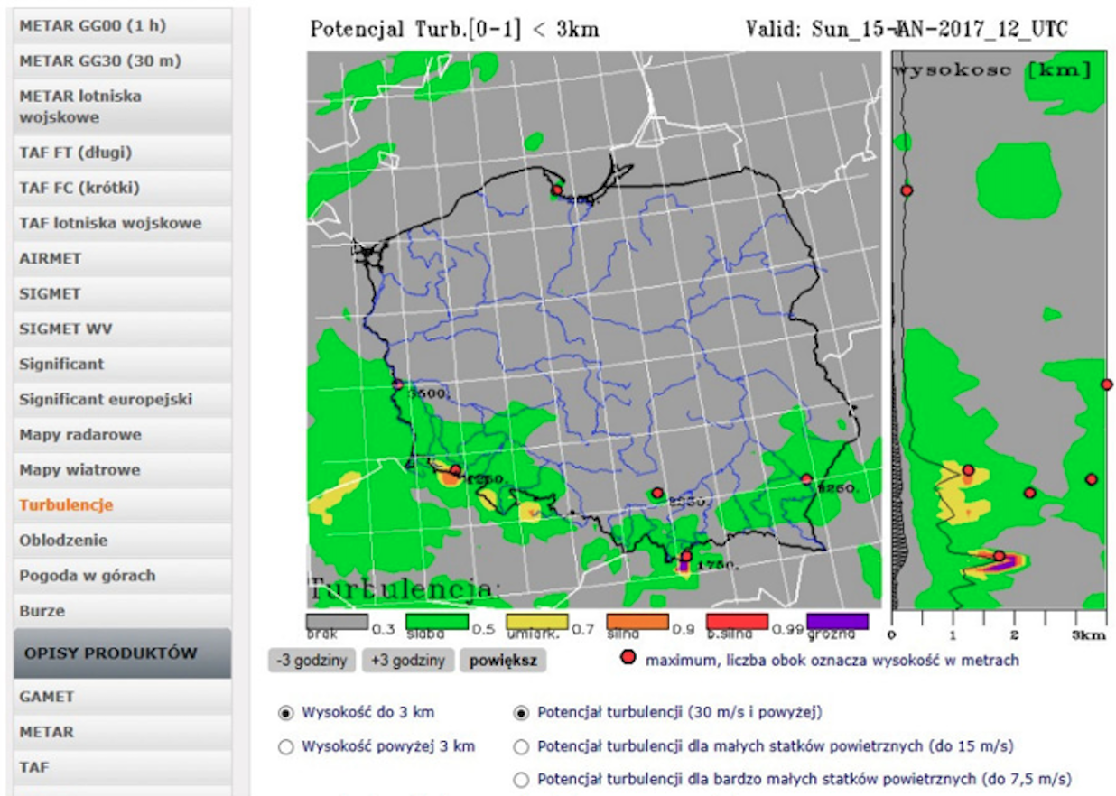
According to the intensity, turbulence is divided into light, medium and strong. At the second and third degrees, changes in flight altitude are felt, there are difficulties with maintaining control of the plane, and the overload reaches over 1G. Turbulence is difficult to observe from the ground, therefore, in most cases, the only available evidence of its occurrence is aircraft observations. Therefore, if during the flight there are meteorological conditions which, in the opinion of the captain, may affect the safety of flights of other aircraft, he is obliged to notify ATC of this fact as soon as possible.
Wind shear.
It also turned out that low-altitude turbulence is also dangerous. However, they are usually predictable. They arise due to topography or significant temperature differences in hot climates. Among the turbulence at low altitude, wind shear is the most dangerous. But it was only learned about it in the 80's.
Research carried out in 60 years by NASA, FAA and other organizations gave man the false belief that we have known the mechanisms occurring in the atmosphere so that we are able to safely pass turbulence phenomena. The problem arose in the 1960s, when modern F-111 planes were sent to Vietnam for the war, which could fly fast and low in accordance with the terrain. In the first months, six machines were lost. Initial information that the planes had been knocked down has not been confirmed. The Vietnamese did not know anything. The truth turned out to be brutal - turbulence. The alarm has not yet been announced. These were military planes. Difficult terrain and enormous speeds.
Lockheed set out to build a wide-body commercial aircraft, an engineering marvel that will outperform its competitors in every respect. Two things were most important. First of all, the lowest fuel consumption per passenger. Second, the possibility of landing in conditions in which competitors do not land. The Lockheed L-1011 TriStar flown on November 16, 1970. And he was like that, except that landing in all conditions is impossible.
On August 2, 1985, Delta Air Lines Flight 191 Lockheed L-1011 TriStar, N726DA, was on a domestic flight from Fort Lauderdale, Florida, to Los Angeles, via Dallas. The plane crashed in severe weather during the approach to landing in Dallas. 136 people on board and a passenger car driver on a nearby highway were killed. 27 people survived. The main cause of the crash was wind shear.
Before the flight, the crew received a weather forecast for the planned route. It said rain and thunderstorms possible. Already during the flight, the crew received another warning about single storms over Oklahoma and Texas. The start took place at 15:00. After passing New Orleans, the crew decided to re-route a bit and fly further north to avoid local storms. At 17:35 the crew received another automatic weather information about bad weather conditions. Moments later, an air traffic controller ordered them to descend to 25,000 ft (7,600 m). At 5:43 pm, the controller ordered the ceiling to be lowered to 10,000 ft (3,000 m) and heading to 250 degrees. But the captain said he would rather walk around the next storm, left or right, than enter it. After an exchange of views, the controller set a new course and ordered a descent to 9,000 ft (2,700 m). The captain was relieved. At 17:51 the aircraft was handed over from one Fort Worth ARTCC area control to the other DFW Airport Control approach. A ceiling is mandated to 7,000 feet (2,100 m). The crew started the landing preparation procedure. At 17:54 the controller ordered the speed to be lowered to 180 knots (210 mph) and corrected the course. The crew did everything. By 17:56 the aircraft had an altitude of 5,000 ft (1,500 m). The inspector informed that there was no rain north of the airport and that landing would be done according to the ILS system. A moment later the first officer said - "We will wash our plane." At that time, the controller announced - "RWY 17L". There were two planes in front of Lockheed L-1011 on the same approach. The first crew said they had to get out of this shower as soon as they could, and she didn't land. Second was the Learjet 25. The Learjet 25 encountered heavy rain and lost sight to the front, but was able to continue its ILS approach and landed safely. Thus, the ILS got vacant for the L-1011. At 6:00 PM, the crew of the Lockheed L-1011 received further guidance - altitude to 3,000 feet (910 m) and speed to 170 knots (200 mph). Subsequent commands are 2,300 feet (700 m) and up to 160 knots (180 mph). At 18:03 the controller announced that the wind direction had changed. Runway runway RWY 17L landing service controller saw lightning from a storm cell after the Learjet 25 landed. At 6:03 PM the controller again requested a speed reduction of 150 knots (170 mph), and informed the tower controller. This informed L-1011 Flight 191 of heavy rain and wind gusts up to 15 knots (17 mph). The crew extended the landing gear and gave full landing flaps. At 6:04 pm, the crew saw lightning in front of them and entered the storm. It was about 7,000 m to RWY. Service ceiling 1,000 ft (300 m). At 18:05:26 the crew gave full engine power with the intention of departing. The plane jerked its nose up, but instead of rising it began to fall. At moments 50 ft / s. He was definitely under the glide path now. The "whoop whoop pull up" alarm sounded. The captain threw "Toga" maximum thrust and walk away. At 6:06 pm the plane was still going missing at a rate of about 10 feet per second. The wheels touched the plowed field to the left of the glide path 6,336 feet (1,931 m) north of the runway and 360 feet (110 m) east of the runway center line. The plane crashed onto the highway and hit a passenger car, killing the driver. He mowed down street lamps. Systematic destruction of the plane took place. The plane caught fire. The plane's tail and nose fell off. Eventually it crashed into metal water tanks. The fuselage turned and stood in the fireball. After a lengthy investigation, the NTSB found the captain guilty of the crash. He was credited with deliberately entering the storm, although the main cause was a wind shear. The NTSB also found that the lack of specific training, rules and procedures for the avoidance and escape of low-height wind shear was a contributory factor to the disaster. The NTSB criticized the conduct of Dallas airport services. The municipal emergency services were notified only 10 minutes after the disasters, and this notification lasted as long as 45 minutes. This certainly took a toll on the health of those who survived, and perhaps killed those who were still alive. The NTSB investigation of the causes of the accident lasted over two years, and the court hearing took another two. The court found the crew and Delta airline guilty of not providing proper training. The higher court upheld the sentence. In later comments, one cannot avoid the impression that if it were not for the L-1011, the decision to leave would have been made earlier.
Wind shear is a sudden change in the direction and speed of the wind caused by the circulation of air currents under the Cumulonimbus cloud, causing a sudden loss or increase in lift and thus the aircraft throwing itself out of aerodynamic equilibrium. This phenomenon usually lasts from 3 to 5 minutes. The air speed reaches up to 50 m / s. For this reason, take-off and landing planes are the most vulnerable to them. Typically, aircraft approaching landing first get extra lift from underneath. The captain then reduces speed to stay on the path. But after a while, the plane hits the treading currents that crush it to the ground. Or to the currents in the rear of the plane resulting in a loss of lift. The effect is the same. At a higher altitude, the pilot has time to react and regain lift by increasing the speed, but during the landing phase, the plane is at an altitude of several dozen meters above the ground.
The last type of turbulence is that caused by the planes themselves. The phenomenon is extremely dangerous for small planes that come to land right behind large machines. Therefore, proper separation is important.
Finally, good advice. Always wear a seat belt when sitting in an airplane in your seat. Only undo them when you need to get up. There are also belts in the berths for the flight crew.
Written by Karol Placha Hetman