Chojnice 2021-01-07
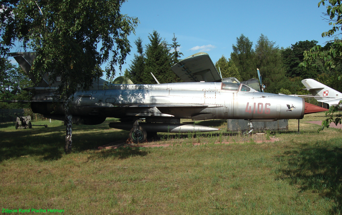
Konarzyny military reserve airport near Chojnice.
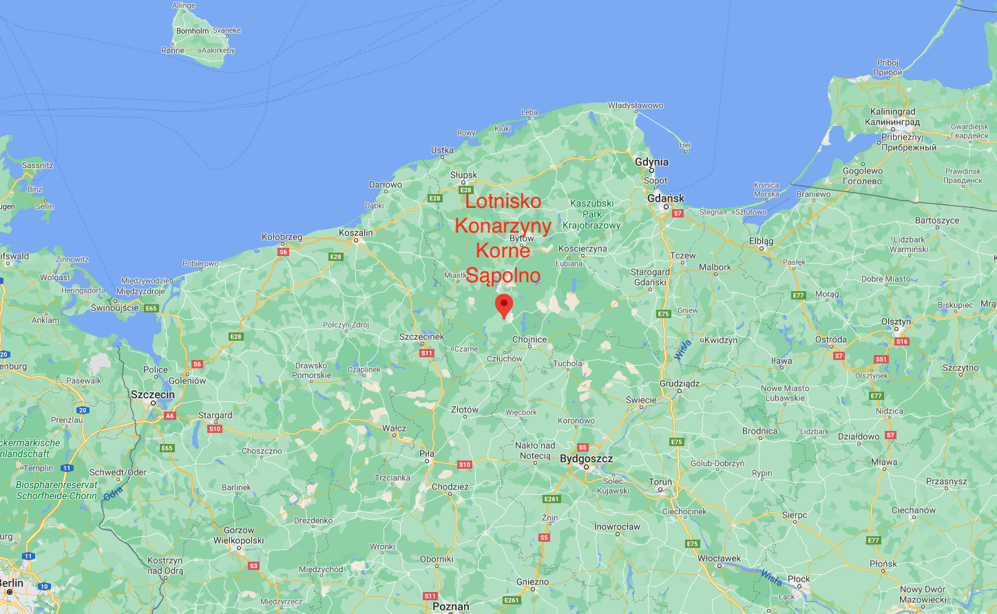
Geographical coordinates: 53.825N 17.352E (or 53°49'31.0"N 17°21'10.0"E).
The nomenclature of individual airports, and especially alternate airports, has caused and still causes some difficulties. It was usually the case that the airport received the name of the poviat town in which it was located. But it could also have received the name of a neighboring town, because there was a post office, or more precisely, a post office and a telephone exchange. Therefore, for a given airport there could be two, and sometimes three names. For example, Konarzyny's alternate airport was also listed as Sąpolno or Chojnice. Nevertheless, in the nomenclature of the Polish Army, there was always one name for a given airport, and so the Konarzyny airport is listed in the documents as Sąpolno. Nowadays, some municipalities admit to ties to former airports, which sometimes manifests itself in street names. Then in these places we can meet the name of Lotnicza or Spadochronowa Street.
The Konarzyny Airport (Korne, Sąpolno) is only 30 km east of the Pieniężnica Airport and, like that airport, it has never had a host in the form of an air regiment that would be based here permanently. Therefore, it was classified as an alternate airport.
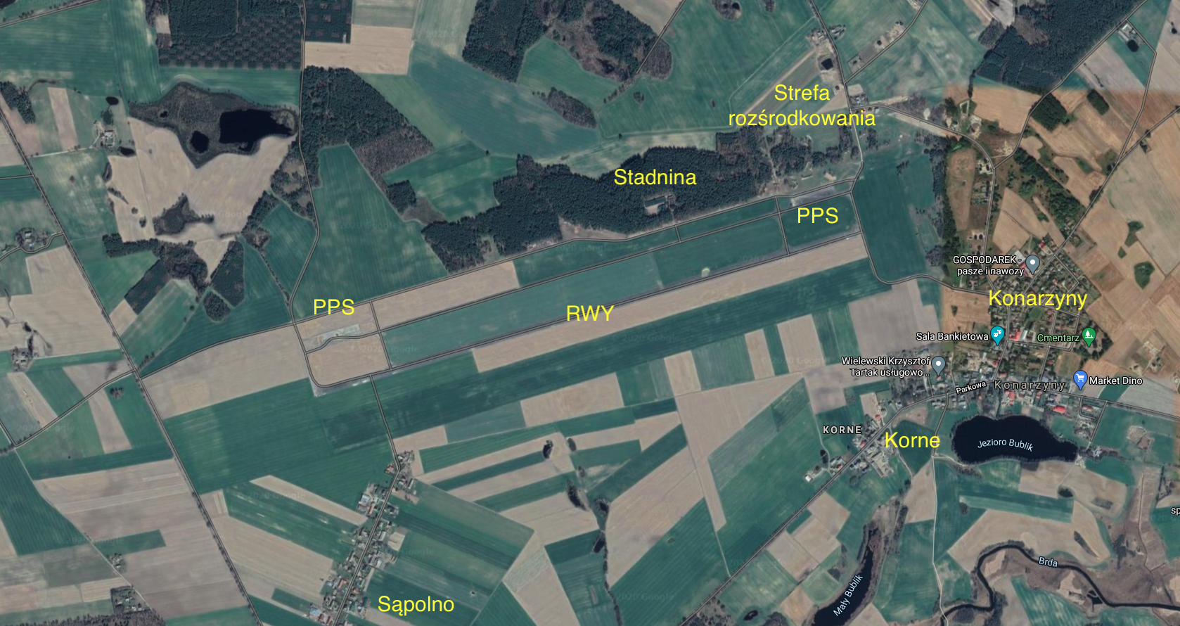
Konarzyny Airport is located in the Pomeranian Voivodeship, in the Chojnice District, in the Konarzyny Commune. The airport was built in the period 1951-1956, when nearly 40 military airports were built in Poland. Konarzyny airport does not have a good location. It was built near several villages, in a typically agricultural area. Only on the north side of the airport is a small forest. All the necessary elements of the airport infrastructure have been placed in the forest. The total area of the airport is 250 hectares. Elevation 490 ft (149 m). It is 18 km from the airport to Człuchów, 22 km to Chojnice, 50 km to Szczecinek, and 50 km to Bytów.
Konarzyny airport has one main RWY, with dimensions of 2,300 m x 30 m, which is located in the direction 074/254. Asphalt and concrete surface. From the south, an emergency runway (RWY) with a ground surface (grass) was marked out. Parallel to the RWY from the northern side, the main taxiway was placed. The taxiway is connected to the RWY by five connectors. Two PPSs were placed on the main taxiway; eastern and western. Each PPS is 50 m x 200 m (10,000 m2). All surfaces are concrete and asphalt.
In the north-eastern part of the airfield, there is a landing zone for aircraft. The pitches have a ground surface surrounded by embankments on three sides.
The main administrative and barracks facilities were located in the center of the forest. Currently (2021) there is a horse farm here. The airport has never been fenced off. There was no railway siding to the airport, but railway line No. 413 ran nearby.
History of Konarzyny Airport.
In 1963, the 32nd Tactical Reconnaissance Aviation Regiment was appointed the host of the spare Konarzyny Airport, which was permanently based in Sochaczew. Around 1980, the spare Konarzyny Airport was hosted by the 9th Fighter Aviation Regiment, which was permanently based in Debrzno. After the 9th Fighter Aviation Regiment was disbanded in 1989, the airport in Konarzyny remained without a host. The airport was transferred to the Military Property Agency. It was considered whether the facility was to retain its aviation character? Ultimately, the requirement to maintain the air character of the facility was abandoned.
Around 2000, Konarzyny Airport was bought by the German company "M and V Marketing i Dystrybucja". The value of the transaction was PLN 7 million. The plans were not rich, because it was intended to build a wind farm at the airport. In 2004, the company went bankrupt and did nothing at the airport. The facility was owned by the Przechlewo Commune (217 hectares) and the Konarzyny Commune (32 hectares), because the company was in arrears with taxes. The company temporarily leased land to farmers for pastures and meadows. The lease had already expired, and the farmers continued to use the land. Buildings that were owned by the army and then companies fell into disrepair. The property was taken over by the trustee for debts. The authorities of Chojnice showed interest in the facility, as they wanted to launch General Aviation air traffic here. In the records of the Civil Aviation Office, the airport is still treated as a landing site, but no codes have been assigned. The former RWY is a fragment of a public road, but with little traffic. If necessary, an emergency landing is possible, but on RWY you can find tires and sand heaps from illegal car rallies.
In 2005, a part of the former airport (administrative and barracks buildings) was bought by a private person, an entrepreneur from Chojnice, who opened a stable here. There are 60-100 horses in the stable. The owner's plans include a hotel and restaurant. Ultimately, the entrepreneur bought the entire area (250 hectares) for PLN 1,300,000. Part of the former landing field is to be divided into plots to be built and sold. The entrepreneur organizes annual harvest festivals and other mass events at the airport, such as exhibitions of horses and agricultural equipment.
Railway line No. 413.
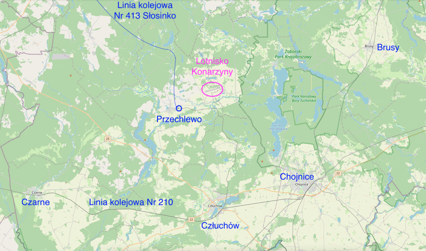
No railway siding reached Konarzyny Airport. However, there is currently (2021) an unused railway line No. 413 near the airport, with two railway stations close to the airport: Przechlewo and Sąpolno. It was from these railway stations that construction material and other goods were delivered to the airport.
The railway line No. 413 connected the Człuchów station (railway line No. 210) with the Słosinko stop and was 55 km long. It was established in 1902. The route was single-track, non-electrified. In 2006, part of the Słosinko-Przechlewo line was demolished, together with the railway siding to the Pieniężnica Airport. Part of the Przechlewo-Cłuchów line, 25 km long, still exists (2021), but is not used. In Przechlewo, the track ends with a retaining trestle in front of a local road. Passenger traffic on this section ended in 2004. From time to time, the Chojnice Association of Railway Enthusiasts organized a special train ride on this route for railway enthusiasts.
Written by Karol Placha Hetman