Szprotawa 2015-11-17
Lotnisko Szprotawa – historia
Kompleksy leśne ciągnące się od Lubina, Polkowic i Głogowa w kierunku zachodnim do dnia dzisiejszego skrywają ogromną ilość obiektów wojskowych. Są tutaj garnizony wojskowe, magazyny, bunkry, lotniska, poligony, byłe obozy jenieckie i inne. Większość z tych obiektów zbudowano w czasach kiedy tereny te należały do strony prusko-niemieckiej. Po drugiej wojnie światowej większość obiektów wojskowych zostało zajęte i rozbudowane przez armię rosyjską, która dostosowała je do wymogów ówczesnego pola walki. Rozbudowano lotniska, a na poligonach pojawiły się atrapy lotnisk, które służyły do ćwiczeń przy użyciu ostrej amunicji, bomb i pocisków kierowanych.
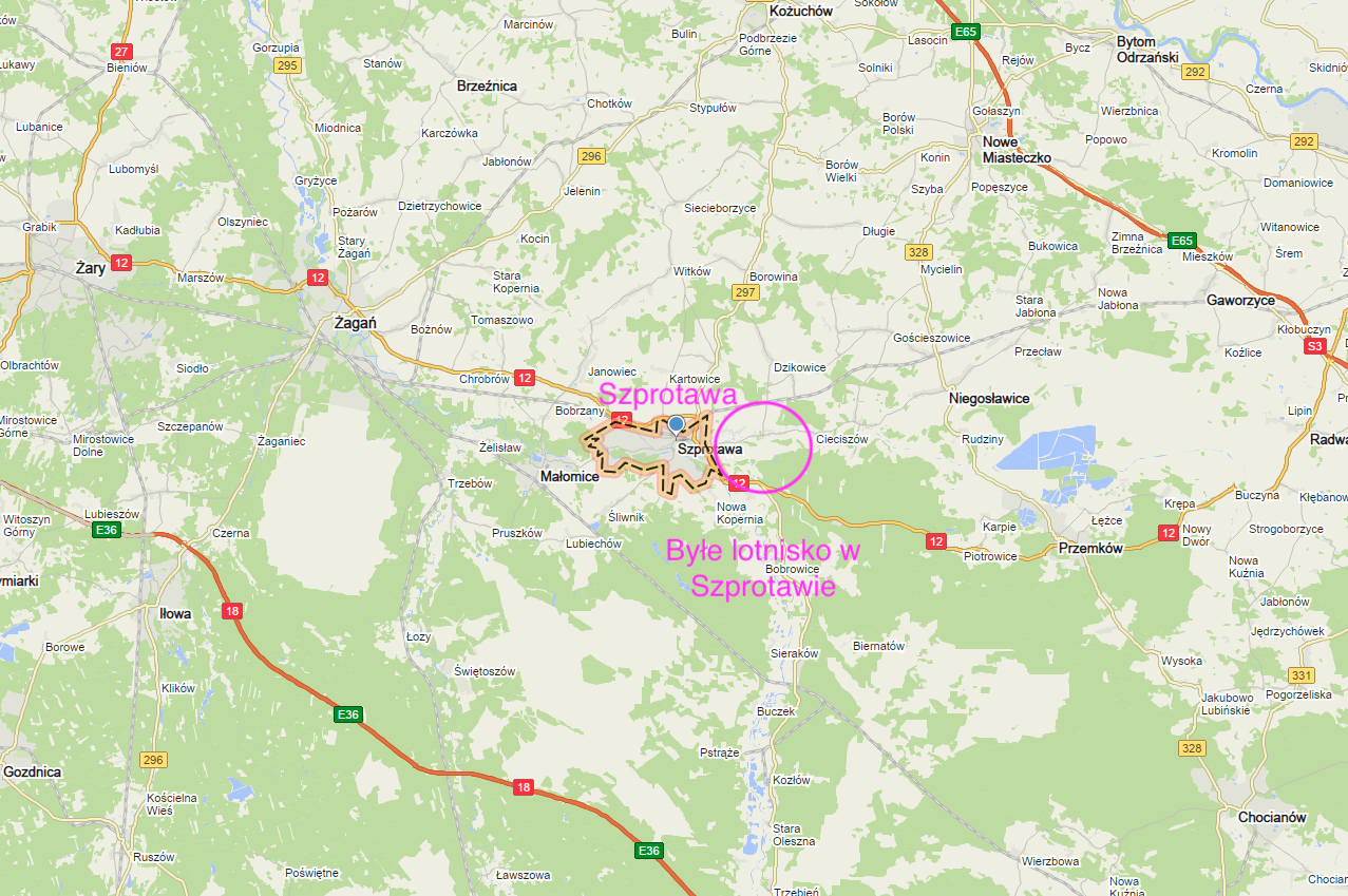
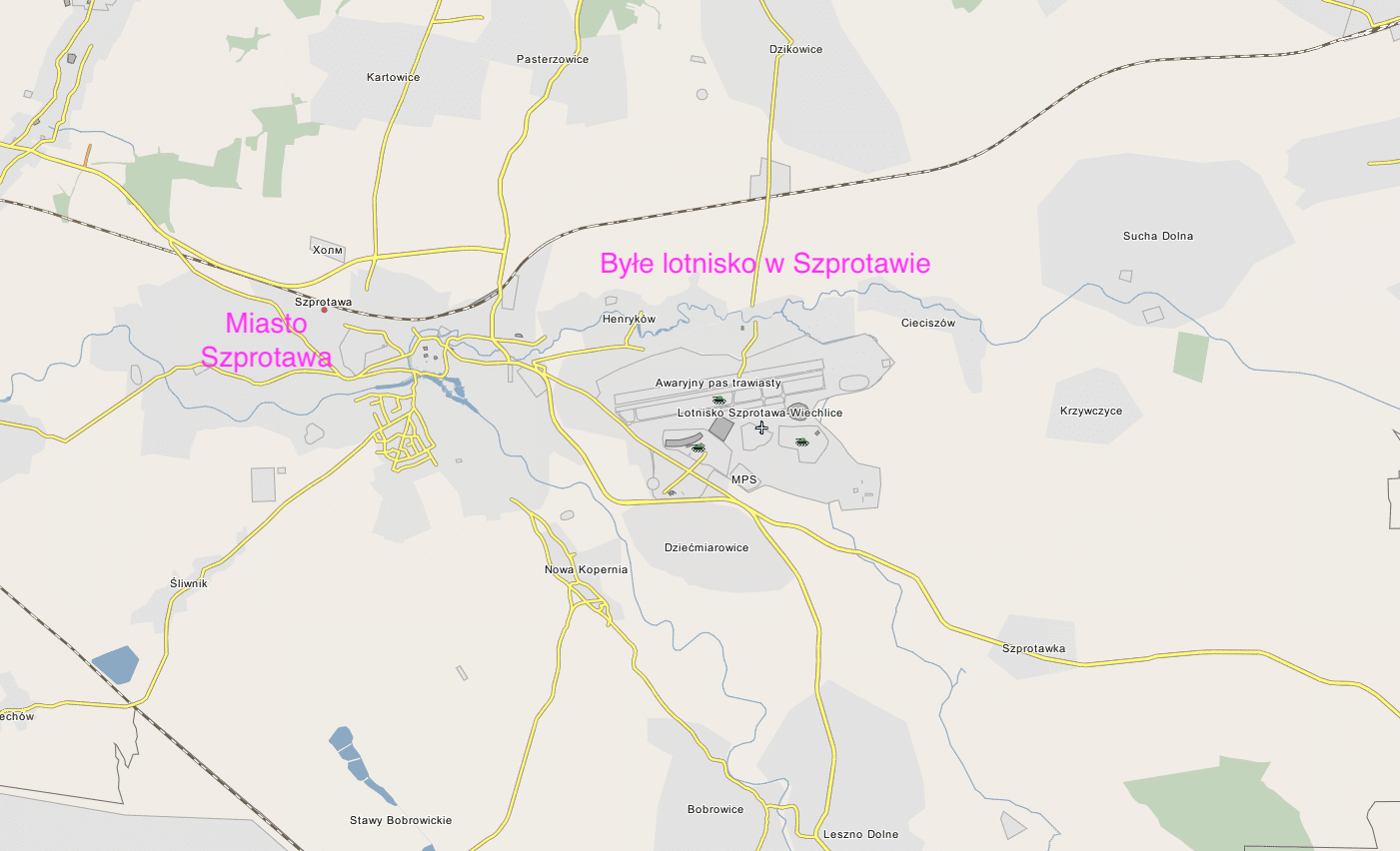
Ten artykuł poświęcony jest byłemu już Lotnisku Szprotawa, które znajduje się na wschód od Miasta na terenach Miejscowości Wiechlice.
Miasto Szprotawa.
Szprotawa (łac. Sprottavia, niem. Sprottau, ros. Шпротава) to niewielkie Miasto w Województwie Lubuskim, w Powiecie Żagańskim. Jest siedzibą Gminy miejsko-wiejskiej. W 2014 roku, zamieszkiwało tutaj ponad 12 000 mieszkańców. Miasto jest ośrodkiem przemysłu drzewnego i spożywczego, gdyż leży na granicy obszarów rolniczych i dużych kompleksów leśnych. Przez Miasto przebiega tylko jedna Droga Krajowa Nr 12, która jest tylko drogą jedno-jezdniową. Dlatego skomunikowanie Miasta zresztą kraju jest słabe. Generalnie z Miasta jest daleko do głównych ośrodków przemysłowych i administracyjnych. Do Zielonej Góry jest 50 km, do Wrocławia 140 km, do Poznania 160 km.
Miasto ma długą historię. Gród istniał tutaj już w X wieku. Do 1138 roku, ziemia szprotawska i głogowska była pod panowaniem książąt piastowskich. Przywilej lokacyjny na prawie średzkim miasto otrzymało w 1260 roku, od księcia Konrada Głogowskiego. W XV wieku Miasto otrzymało prawo bicia własnej monety. Przez długie lata ziemia szprotawska i głogowska była pod zwierzchnością Czech i Niemiec. Szprotawa była urokliwym Miastem, które wolno, ale systematycznie rozwijało się. Do dnia dzisiejszego możemy podziwiać piękne budowle. W dniu 14.02.1945 roku, do Miasta wkroczyła armia CCCP. W wyniku II wojny światowej Miasto trafiło w granice Polski, jako tak zwane „ziemie odzyskane”. Miasto stało się niby Polskie, ale nieograniczoną władzę mieli tutaj Rosjanie, którzy w 1945 roku, osiedlili się tu jako okupanci. Polska administracja ukonstytuowała się dopiero na przełomie 40/50-lat.
Miejscowość Wiechlice.
Wiechlice (po niemiecku Wichelsdorf) położone na wschód od Miasta Szprotawa przez wieki należały do jednego z pruskich rodów. Na przełomie XVIII/XIX wieku zbudowano tutaj zespół pałacowy, który w obecnych czasach został wyremontowany i jest cztero-gwiazdkowym hotelem pod nazwą Pałac Wiechlice. (Zespół pałacowy i miejscowość Wiechlice w stosunku do Lotniska znajdują się z jego północnej strony).
W dniu 1.08.1914 roku, wybuchła wielka wojna światowa. Nie dojść, że wojna ta była wielka i powszechna, to jeszcze Niemcy wprowadzili w życie pomysł ogromnych obozów jenieckie, które z czasem przeradzały się w obozy zagłady, a w czasie II wojny światowej w obozy koncentracyjne. W trakcie wielkiej wojny światowej, na terenie posiadłości Wiechlice Niemcy zbudowali obóz jeniecki. Znajdował się on w zachodniej części późniejszego pola wzlotów lotniska i na wschód od istniejącego do chwili obecnej cmentarza. Do Kriegsgefangenenlager (w wolnym tłumaczeniu obóz jeńców wojennych) przywożono głównie żołnierzy Zjednoczonego Królestwa.
Lotnisko Szprotawa-Wiechlice.
Chociaż obecnie Lotnisko Szprotawa i to co po nim pozostało znajduje się na terenie Rzeczypospolitej Polskiej, nigdy nie było eksploatowane przez Wojsko Polskie. W niewielkiej Miejscowości Wiechlice, na wschód od Szprotawy, po wielkiej wojnie światowej wojsko niemieckie zlikwidowało obóz jeniecki. Teren pozostał jako wojskowy i zorganizowano tutaj plac ćwiczeń, który z czasem przekształcono w poligon artyleryjski. Na części tego poligonu Niemcy założyli Lotnisko. Przypuszczalnie był to w 1934 roku. Nazwano je Fliegerhorst Sprottau. Założono je jako lotnisko cywilne, szybowcowe. Poobozowe baraki wykorzystano dla potrzeb lotniska. Część baraków mogło być wykorzystanych dla przymusowych robotników, którzy budowali Lotnisko. Po dojściu Hitlera do władzy budowa obiektów wojskowych przez przymusowych robotników, więźniów kryminalnych i politycznych była normą. Na przełomie 30/40-lat zbudowano przy lotnisku koszarowiec, magazyny, hangary, skład paliw. W tym czasie Lotnisko miało już powierzchnię ponad 100 hektarów. Część tych obiektów istnieje do dzisiaj i na przykład urządzono w nich hotel Chrobry.
W sierpniu 1939 roku, na Lotnisku stacjonowało około 40 samolotów myśliwskich i około 20 bombowych. W dniu 1.09.1939 roku, Lotnisko posłużyło do ataku na Polskę. Do granicy z Polską było tylko 60 km, a do Leszna niecałe 70 km. Podczas II wojny światowej Lotnisko było intensywnie wykorzystywane. Z chwilą zbliżania się wschodniego frontu na Lotnisku stacjonowały najnowsze niemieckie maszyny wyposażone w silniki turboodrzutowe, które jednak nie odegrały znaczącej roli w walkach.
W dniu 14.02.1945 roku, armia czerwona zajęła Lotnisko i inne obiekty militarne. Jednostki tu stacjonujące należały do pierwszorzutowych. Szprotawa stała się silnym miastem garnizonowym CCCP w okresie 1945 – 1993. Stacjonowały tutaj następujące jednostki rosyjskie:
Dywizja Lotnictwa Bombowego 4. Armii Lotniczej. Dywizja od 1988 roku, miała numer 149. Początkowo była to dywizja myśliwska, a następnie myśliwsko-bombowa. Dywizja oficjalnie stacjonowała w Szprotawie od 1955 roku.
89 Pułk Lotnictwa Bombowego, poprzednio 18. Pułk Lotnictwa Myśliwskiego.
3 Pułk Lotnictwa Bombowego, który poprzednio był 534. PLM.
582 Pułk Lotnictwa Myśliwskiego.
42 Pułk Lotnictwa Bombowego, który stacjonował na nieodległym lotnisku w Starej Koperni Tomaszowie, na wschód od Żagania.
314 Samodzielna Eskadra Śmigłowców.
Ruchoma Samochodowa Baza Remontowo-Techniczna.
Samodzielny Batalion Zabezpieczenia Lotniskowo-Technicznego 89. plb.
Samodzielny Batalion Łączności.
Samodzielny Batalion Łączności i Zabezpieczenia Radiotechnicznego 89. plb.
Samodzielny Rakietowy Dywizjon Przeciwlotniczy.
Samodzielna Kompania Zabezpieczenia Lotniskowo-Technicznego 314. eś.
Baza broni atomowej (jądrowej).
Nie jest to pełne wyliczenie, ale na tym nam nie zależy. Nie piszemy historii CCCP, tylko rosyjskiego lotniska na terenie Polski.
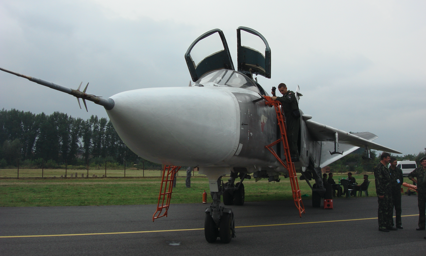
Samoloty bojowe używane przez Dywizję: MiG-15 (od 1950 roku), MiG-17, MiG-21, Su-17 (od 1975 roku), Su-7 U (od 1974 roku), Su-24 M (od 1982 roku). Oprócz samolotów bojowych w Szprotawie były śmigłowce: Mi-8 (w tym Mi-9 – stanowisko dowodzenia), Mi-24 W, Mi-24 K, Mi-24 RCh. Samoloty opuściły Szprotawę do dnia 7.07.1992 roku. Resztę sprzętu i personelu ewakuowano samolotami Tu-134, Ił-76 i An-12 oraz eszelonami.
Rosjanie rozbudowali Lotnisko. Jego obszar został znacznie powiększony. Cały teren lotniska, z polem wzlotów, zapleczem lotniska i zajętym kompleksem leśnym miało ponad 500 hektarów. Wybudowano betonową drogę startową RWY, która ostatecznie miała wymiary 2 500 m x 60 m. Zbudowano drogi kołowania, które także wykorzystywano do startu, kiedy na lotnisku były samoloty myśliwskie. Zbudowano kilka wielkich hangarów. Do chwili obecnej (2015 roku) pozostało ich pięć. W 70-latach powstały pierwsze schrono-hangary. Zbudowano także CPPS o wymiarach 550 m x 40 m.
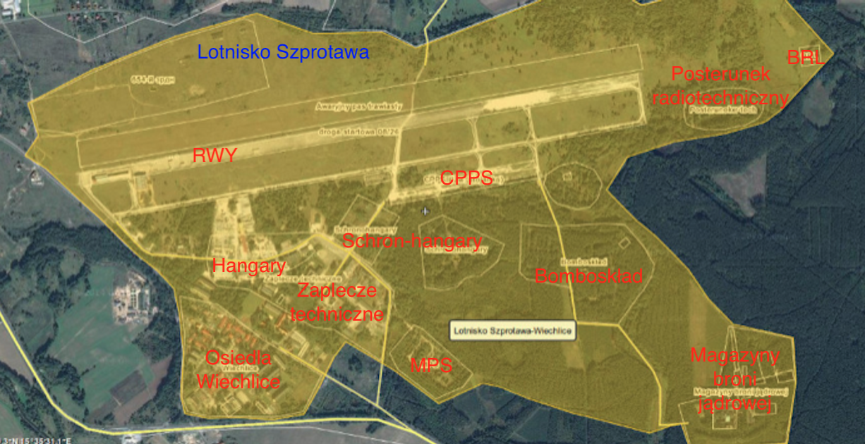
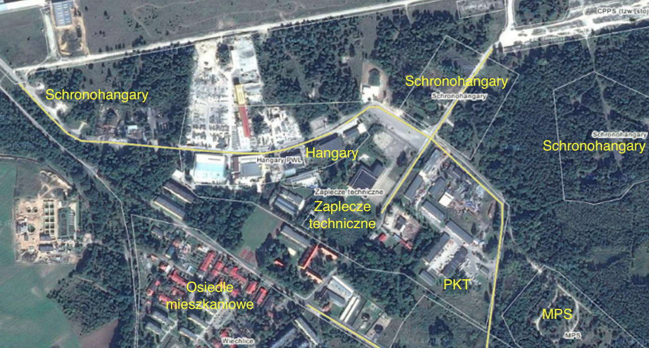
W pobliżu rozbudowano osiedle oficerskie na którym za czasów niemieckich zbudowano około 20 niewielkich bloków mieszkalnych. Najnowsze bloki mieszkalne, czteropiętrowe postawiono w 60-latach. Bloki budowały Polskie firmy budowlane, a finansowało państwo Polskie. Bloki zbudowano według typowych planów z 60-lat. Rosjanie otwarli tutaj 10-klasową szkołę średnią dla dzieci z oficerskich rodzin, która obecnie (2015 roku) jest Polską szkołą podstawową gminną.
Łącznie na terenie bazy postawiono ponad 200 różnych budynków i budowli. Są stare poniemieckie koszary (Hotel Chrobry), trzy koszarowce z 60-lat, wielki skład materiałów pędnych i smarów, itp.
W okolicy zbudowano jeszcze kilka innych obiektów militarnych. Jednym z nich był skład broni jądrowej (atomowej). Został on zlokalizowany w lesie na południe od lotniska. Przypuszczalnie powstał z początkiem 70-lat. Wynika to z faktu, że w 1974 roku, wprowadzono na uzbrojenie samoloty uderzeniowe Su-17, zdolne do jej przenoszenia. Poprzednie samoloty bazujące w Szprotawie, MiG-17 i MiG-21 nie były przystosowane to ataku jądrowego, a nawet bombami zwykłymi dużego wagomiaru. Jednak do chwili obecnej toczony jest spór, czy w obiekcie była broń jądrowa? Wszystko wskazuje na to, że tak. Licznik Geigera-Mullera nie wykrywa żadnego promieniowania, bo źródło promieniowania zostało usunięty.
Lotnisko Szprotawa w nowej rzeczywistości.
Kiedy w 1993 roku, Rosjanie opuścili Szprotawę, Wojsko Polskie nie przejęło tego terenu i obiektów tu zbudowanych. Wszystko przejęło Miasto Szprotawa. Od tego czasu Lotnisko stało się nieczynne i stopniowo znikał jego lotniczy charakter. Tereny leśne przeszły pod zarząd nadleśnictwa. Osiedle oficerskie stopniowo wyremontowano i mieszkania sprzedano. Otwarto tutaj hotel Chrobry (w pierwszych koszarach pilotów) i gminną szkołę podstawową (w budyniach po szkole średniej rosyjskiej). Budynki na terenie lotniska przejęły różne podmioty gospodarcze. Od około 2007 roku, pole wzlotów jest stopniowo zabudowywane. Stało się ono terenem pod inwestycje przemysłowe – Strefa Inwestycyjna Lotniska.
Współrzędne Lotniska: 51 stopni 33 minuty N, 15 stopni 35 minut E.
Opracował Karol Placha Hetman